| Sunday | Sunday Night | Monday | |
|---|---|---|---|
| Cloud Cover: | Mostly Cloudy | Partly Cloudy | Partly Cloudy |
| Temperatures: | 25 to 31 deg. F. | 16 to 21 deg. F. | 29 to 33 deg. F. |
| Wind Direction: | Southwest | South | South |
| Wind Speed: | 15G28 | 14G25 | 13G24 |
| Snowfall: | 0" in. | 0" in. | 0" in. |
| Snow Line: | 3000' | 3500' | 2500' |
Whitefish Range
Swan Range
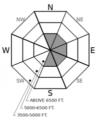
How to read the forecast
Today, expect wind slabs to be stubborn and isolated to upper elevations just below ridgelines. Avoid this terrain by sticking to the light, fluffy snow in wind sheltered locations. If we see warmer temperatures and stronger sunshine than expected, the danger will rise to MODERATE as the recent snow moistens and sluffs off of steep terrain.

1. Low
?
Above 6500 ft.
1. Low
?
5000-6500 ft.
1. Low
?
3500-5000 ft.
- 1. Low
- 2. Moderate
- 3. Considerable
- 4. High
- 5. Extreme
-
Type ?
-
Aspect/Elevation ?

-
Likelihood ?CertainVery LikelyLikelyPossible
 Unlikely
 -
Size ?HistoricVery LargeLargeSmall

Gusty southwest winds on January 17th drifted snow onto leeward aspects. Observers have found these predominately isolated to just below ridgelines. Although they are becoming increasingly more stubborn, they still exist and can be dangerous if they push you into a terrain trap. Avoid dense, pillowy slabs by sticking to terrain that was sheltered by the wind.
-
Type ?
-
Aspect/Elevation ?

-
Likelihood ?CertainVery LikelyLikelyPossible
 Unlikely
 -
Size ?HistoricVery LargeLargeSmall

Last week, observations of large to historic size avalanches failed on persistent weak layers buried in the middle and bottom of the snowpack. These avalanches occurred at upper elevations on leeward aspects, mostly in the Flathead Range. There have been few reports of persistent slabs in the Swan and Whitefish Ranges. Although triggering a slide is unlikely today, continue to be cautious of upper elevation start zones that have variable snow cover and rocky outcroppings, as shown here, where you are more likely to collapse a weak layer.
Our obvious hazard today is the lingering wind slabs that remain predominately at upper elevations on leeward ridgelines. The slabs are becoming increasingly harder to trigger each day. On Thursday, winds reached speeds capable of transporting snow, making wind slabs and cornices touchy. On Friday, Zach found wind slabs to be difficult or stubborn to trigger. The healing trend will continue today, but we are not in the clear yet. My decision making has been easy with this problem. Avoid dense drifts and seek out the cold, fluffy powder that is found further down the slope or on windward terrain; not only is it safer, but its also better riding.
Persistent slab avalanches several feet thick or more remain an isolated concern. Persistent weak layers of faceted crusts and surface hoar formed at mid and upper elevations in late December, and are getting deeply buried by bountiful snow in January. Large to very large persistent slab avalanches that occurred last week were mostly on upper elevations and on leeward aspects. Mapping out avalanche activity is an excellent tool for managing this problem. Be sure to look at the remarkable destruction of an avalanche that occurred last week in the Flathead Range (observation). Seeing mature trees being ripped out of the ground is a reminder of the sheer power of these kinds of avalanches.
A loose wet avalanche cycle is at our door as high pressure brings warming temperatures and increasing sunshine by Monday. There is uncertainty on how today's weather will play out and the timing of wet loose activity. Today we expect temperatures to hover just below freezing with a thick deck of stratus clouds and some upper elevation clouds to inhibit solar gain. If the sun does find its way onto the slope you are on, or the slope that is above you, watch for rollerballs or pinwheels. Those are early signs to avoid sun-exposed slopes. IF we see a decent amount of sunshine today, expect the avalanche danger to rise to MODERATE.
A ridge of high pressure sets into the area bringing warming temperatures and valley inversions. Today temperatures will hover at or just below freezing at low and mid elevations. Winds will be light out of the south to southwest.
This forecast applies only to backcountry areas outside established ski area boundaries. The forecast describes general avalanche conditions and local variations always occur. This forecast expires at midnight on the posted day unless otherwise noted. The information in this forecast is provided by the USDA Forest Service who is solely responsible for its content.


