| Saturday | Saturday Night | Sunday | |
|---|---|---|---|
| Cloud Cover: | Mostly Cloudy | Mostly Cloudy | Decreasing Clouds |
| Temperatures: | 18 to 23 deg. F. | 14 to 18 deg. F. | 25 to 31 deg. F. |
| Wind Direction: | Southwest | Southwest | Southwest |
| Wind Speed: | 5 to 10, G20 | 5 to 10, G20 | 5 to 15, G25 |
| Snowfall: | 1" to 2" in. | 1" to 2" in. | 0" in. |
| Snow Line: | 500' | 2000' | 2000' |
Whitefish Range
Swan Range
How to read the forecast
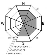
Today's quiet weather will make natural avalanches unlikely. Human triggered slabs breaking in recently drifted snow, or on deeply buried weak layers, remain a concern. Staying away from steep wind loaded terrain, where these problems overlap, will offer the safest riding.

2. Moderate
?
Above 6500 ft.
2. Moderate
?
5000-6500 ft.
1. Low
?
3500-5000 ft.
- 1. Low
- 2. Moderate
- 3. Considerable
- 4. High
- 5. Extreme
-
Type ?
-
Aspect/Elevation ?

-
Likelihood ?CertainVery LikelyLikelyPossible
 Unlikely
 -
Size ?HistoricVery LargeLargeSmall

Yesterday's winds formed slabs of drifted snow near exposed ridgelines, below cornices, and in cross-loaded terrain. Observers yesterday reported blowing snow, thick drifts, and triggered wind slabs. (Example A, Example B). Although these recently formed slabs won't be as tender as yesterday, they may remain sensitive to human triggers today. Drifts will be larger and more dangerous in high elevation terrain that received abundant snow transport. Seek out wind-sheltered slopes for softer snow and less hazard. You know you've found a wind slab if the snow feels thicker and denser, if the surface looks rounded and pillowy with textures of wind transport nearby, or if you see cracks shooting from beneath you.
-
Type ?
-
Aspect/Elevation ?

-
Likelihood ?CertainVery LikelyLikelyPossible
 Unlikely
 -
Size ?HistoricVery LargeLargeSmall

Several very destructive hard slab avalanches ran earlier this week in the neighboring Flathead Range (Example A, Example B). Avalanches breaking on buried persistent weak layers have been rare in the Whitefish and Swan Ranges. Here's an example of one from the Northern Whitefish Range. Although they are becoming increasingly difficult to trigger, there are still a few areas where concerning persistent slab structures exist at mid and upper elevations. The biggest concern is for a large cornice fall or a shallow slide in the upper snowpack to overload one of these stubborn slabs. Be wary of rocky terrain with variable snow depths where winds recently added more stress.
Day-old wind slabs will be the most obvious avalanche concern today. The strongest winds of the week showed up yesterday, with gusts reaching 35 to 45 mph at mountain stations. Wind stations reported southwest winds, although observers yesterday noted westerly or even northwesterly winds. Winds had plenty of low-density snow to work with: slabs could be several feet thick in terrain with large fetches, most commonly as you climb above treeline. Slabs will be more difficult to trigger than yesterday now that wind loading has fizzled, but it is easy enough to avoid them for higher quality powder and less hazard.
Persistent weak layers buried in the middle and bottom of the snowpack produced quite the clatter earlier this week, particularly in the Flathead Range. Several D3 to D4 avalanches failed off Cameawait and Nyack, and a hard slab was spotted in the Northern Whitefish Range. These slides failed while the snowpack was stressed by a prolonged loading period. Yesterday's increased wind transport continued to add weight to leeward slopes. Now we enter into calmer weather for the weekend, allowing the snowpack to start to settle and adjust. Predicting and managing for deep instabilities is challenging: It carries a high amount of uncertainty paired with high consequences. Although persistent and deep persistent slabs are becoming more difficult to trigger, a resulting avalanche will be difficult to escape from. Be cautious of the type of terrain that these slides have failed in. Our photo galleries and observations are helpful starting points. The slides have shared common characteristics: leeward or cross-loaded terrain, steep, often with variable snow depths or near rock bands. Well anchored, concave, wind-protected slopes with uniform snow depths appear to be a lower risk option for handling the uncertainty right now.
Quiet weather is in store for the next few days as a high-pressure ridge moves onto the Pacific Coast towards Montana. Wind gusts have mercifully eased overnight, gusting into the teens at ridgetop early this morning. They should continue to be light to moderate throughout the weekend. Light snow showers are expected today ahead of a drying, sunnier trend into Monday as the ridge moves overhead.
This forecast applies only to backcountry areas outside established ski area boundaries. The forecast describes general avalanche conditions and local variations always occur. This forecast expires at midnight on the posted day unless otherwise noted. The information in this forecast is provided by the USDA Forest Service who is solely responsible for its content.


