| Friday | Friday Night | Saturday | |
|---|---|---|---|
| Cloud Cover: | Decreasing clouds | Mostly Cloudy | Overcast |
| Temperatures: | 20 to 25 deg. F. | 10 to 15 deg. F. | 20 to 25 deg. F. |
| Wind Direction: | Southwest | Southwest | South |
| Wind Speed: | 20 to 25 G40 | 5 to 15 G25 | 5 to 15 G25 |
| Snowfall: | 1 to 2" in. | 2 to 4" in. | 1 to 3" in. |
| Snow Line: | 500' | 0' | 500' |
Swan Range
How to read the forecast

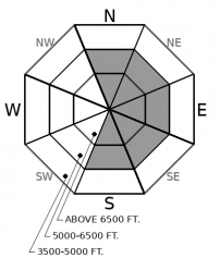
2. Moderate
?
Above 6500 ft.
2. Moderate
?
5000-6500 ft.
1. Low
?
3500-5000 ft.
- 1. Low
- 2. Moderate
- 3. Considerable
- 4. High
- 5. Extreme
-
Type ?
-
Aspect/Elevation ?

-
Likelihood ?CertainVery LikelyLikelyPossible
 Unlikely
 -
Size ?HistoricVery LargeLargeSmall

Slabs of wind drifted snow will thicken through the day as westerly winds increase. Stay away from slopes with active wind loading to avoid the problem. Look and feel for blowing snow, cracking underfoot, and thicker or denser snow to identify the problem. Slabs will be forming on the leeward sides of ridges, below cornices, in gullies, and below rocky outcrops or rollovers.
-
Type ?
-
Aspect/Elevation ?

-
Likelihood ?CertainVery LikelyLikelyPossible
 Unlikely
 -
Size ?HistoricVery LargeLargeSmall

In the past week, numerous very large hard slabs have failed in neighboring mountain ranges to the Swan. Persistent slab structures exist on a few slopes at mid and upper elevations on all aspects, but have become increasingly difficult to trigger. The biggest concern is for a shallow slide in the upper snowpack to overload one of these stubborn slabs. Be wary of rocky terrain with variable snow depths where winds are actively loading today.
Today's go-to terrain is wind protected powder riding. Early this morning, a band of snow showers will leave us with 2" to 4" inches. If you are out of the wind, the new snow should be well behaved. It might produce shallow sluffs in steeper terrain so keep an eye on what type of terrain is below you. Winds are forecasted to increase into the 20's and 30's out of the west after this band of snow showers passes. The Swan, Flathead, and Glacier Park are favored. Increasing winds will redistribute the new snow into thicker and more cohesive slabs in typical loading areas. Slabs will grow larger through the day, especially in high, alpine terrain of the Flathead Range and Park. There is plenty of great powder riding right now away from the winds; steer towards that and it should be a fun day.
The joker in the deck is the lingering persistent slab problem. Numerous persistent slab avalanches released during the loading event earlier this week. The Flathead Range saw the brunt of the activity: numerous D3 to D4 hard slabs failed in upper elevation start zones but ran to valley bottoms, smashing trees on their way down. If you are putting a skin track into the Park or Flathead Range today, remember that winds will be actively loading slopes high above you. Pick a route up that puts you out of the line of fire in case another big one runs. A couple of avalanches involving older crusts were also spotted in the Whitefish Range from the last storm. All of these layers are getting buried deeply and are difficult to trigger. The biggest concern for triggering one today is either from a step-down avalanche that starts in the upper snowpack, or if you are riding in terrain where the snowpack is rocky and has variable snow coverage from winds. So back to Square 1. Stay out of the winds for safer riding today.
Seasonable mountain temperatures exist across the forecast area, ranging from upper teens to high 20's. Marias Pass is the exception, where very cold air is spilling towards Essex this morning. A band of snow showers is moving eastward across the forecast area this morning, which should leave a 2" to 5" across the forecast area, favoring the Swan Range. Drier air and increasing winds follow behind the snow band.
This forecast applies only to backcountry areas outside established ski area boundaries. The forecast describes general avalanche conditions and local variations always occur. This forecast expires at midnight on the posted day unless otherwise noted. The information in this forecast is provided by the USDA Forest Service who is solely responsible for its content.


