| Friday | Friday Night | Saturday | |
|---|---|---|---|
| Cloud Cover: | Increasing Clouds | Overcast | Mostly Cloudy |
| Temperatures: | 15 to 20 deg. F. | 13 to 18 deg. F. | 21 to 26 deg. F. |
| Wind Direction: | Southwest | Southwest | Southwest |
| Wind Speed: | 10 to 20, G30 | 10 to 20, G30 | 5 to 15, G30 |
| Snowfall: | 2" in. | 6" to 10" in. | 4" to 5" in. |
| Snow Line: | 0' | 1500' | 1500' |
Whitefish Range
Flathead Range and Glacier National Park
How to read the forecast
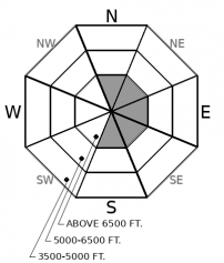
Avalanche activity has quieted down since Wednesday, but there is potential for skiers or riders to trigger a slab avalanche several feet thick that fails on a buried crust or surface hoar layer. Careful snowpack assessments and terrain selection are key. Steep terrain with abrupt rollovers or previous wind-loading is where you are most likely to find lingering trouble. A series of wintry storms are approaching the region starting this afternoon. The avalanche danger will rise overnight towards CONSIDERABLE.

2. Moderate
?
Above 6500 ft.
2. Moderate
?
5000-6500 ft.
1. Low
?
3500-5000 ft.
- 1. Low
- 2. Moderate
- 3. Considerable
- 4. High
- 5. Extreme
-
Type ?
-
Aspect/Elevation ?

This snow profile from yesterday highlights the poor snowpack structure that has produced a number of large avalanches earlier this week. There are several tricky weak layers: surface hoar and faceted crusts, that are buried by slabs several feet thick. Without X-Ray vision, you can't tell which slopes are the potential trouble makers. Careful snowpack assessments and conservative terrain selection are the best tools to increase your margin for safety if you are traveling in avalanche terrain. Stubborn persistent slabs occasionally bark at us with obvious warning signs: collapses or shooting cracks. However, the absence of such is not a free ticket to ride anywhere. Start with smaller, less consequential terrain if you are seeking steeper slope angles.
-
Type ?
-
Aspect/Elevation ?

-
Likelihood ?CertainVery LikelyLikelyPossible
 Unlikely
 -
Size ?HistoricVery LargeLargeSmall

There is just enough wind and transportable snow to continue wind drifting in the highest peaks, as noted in this observation. Recently formed slabs of drifted snow are small and should be isolated to just below ridgelines or in high elevation gullies. Steer around them if you don't want to get knocked off your feet in serious terrain. With a few inches of new snow expected by this afternoon, winds will have a bit of extra fuel to work with. Pay attention to fresh wind loading and changing conditions as the storm arrives. Tonight, wind slabs will become larger and more widespread.
Avalanche activity on buried persistent weak layers peaked on Tuesday and Wednesday and has quieted since. On Tuesday, Clancy remotely triggered a slide that stepped down to a faceted crust, and similar activity occurred in the Whitefish Range. Numerous large naturals (D2 to D2.5) ran in the Flathead Range, the Swan Range, and John F Stevens Canyon on Tuesday or Wednesday morning. Our avalanche database is a good resource for viewing activity. This crown photo from one of the avalanches in John F Stevens Canyon illustrates the layering of the snowpack: it looks like wind slabs that formed during the storm stepped down to the late December weak layers across much of the slope, and potentially down to the November 19th crust in the most heavily windloaded feature.
We did not receive any reports of obvious signs of instability yesterday. The snowpack is recovering, but the rate of slope specific healing depends on a lot of variables. How bad was the weak layer? How severe was the snow loading and wind loading? Large grained weak layers, like surface hoar, tend to heal slower than small grained facets. Crusts often amplify weak layer instabilities because they provide a distinct hardness change and promote faceting at their boundaries. We have a recent blog post that describes the distribution, complexity, and uncertainties surrounding the weak layers that formed during the holidays. If you are seeking steep terrain, monitoring the snowpack structure can help reduce surprises. Give yourself a wide margin for error in your assessments given the potential for spatial variability across slopes or as you change aspects or elevation. Terrain selection is the silver bullet when you are in doubt. Opting towards smaller, simpler, or less consequential slopes can make all the difference if your assessments are wrong.
A series of wintry storms are approaching the region starting this afternoon. We are only expecting a few inches of snow and moderate winds by sunset, and have highlighted the potential for small, fresh wind slabs to develop in the highest peaks of the Flathead Range, Glacier Park, and Northern Whitefish Range. If the storm arrives sooner, or stronger, than expected, watch for conditions to change quickly. The avalanche danger will rise overnight towards CONSIDERABLE.
Brrrrrrrrr! Our first taste of wintry temperatures in a long time. Cold, arctic air has spilled into the region with mountain temperatures in the single digits and a few valley locations dropping below zero. Winds are light to moderate at upper elevations. A low-pressure system off of the Pacific will bring a healthy shot of snowfall to the region starting this afternoon. Storm totals should exceed a foot by tomorrow afternoon in favored areas.
This forecast applies only to backcountry areas outside established ski area boundaries. The forecast describes general avalanche conditions and local variations always occur. This forecast expires at midnight on the posted day unless otherwise noted. The information in this forecast is provided by the USDA Forest Service who is solely responsible for its content.


