| Tuesday | Tuesday Night | Wednesday | |
|---|---|---|---|
| Cloud Cover: | Overcast | Mostly Cloudy | Overcast |
| Temperatures: | 26 to 32 deg. F. | 20 to 25 deg. F. | 24 to 30 deg. F. |
| Wind Direction: | Southwest | South | Southwest |
| Wind Speed: | 10 to 15 gusting to 25 | 15 to 20 gusting to 35 | 15 to 20 gusting to 40 |
| Snowfall: | 8" to 9" in. | 5" to 7" in. | 3" to 6" in. |
| Snow Line: | 4000' | 4000' | 2500' |
Whitefish Range
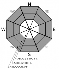
How to read the forecast
New and drifted snow will cause the danger to rise rapidly by this afternoon. Exercise more caution the higher up you go. Today, large avalanches can fail in the new snow and on buried weak layers. Rain and rising freezing levels may cause loose wet avalanches at lower elevations. Choosing low-angle slopes and simple terrain will help keep you safe.

3. Considerable
?
Above 6500 ft.
3. Considerable
?
5000-6500 ft.
2. Moderate
?
3500-5000 ft.
- 1. Low
- 2. Moderate
- 3. Considerable
- 4. High
- 5. Extreme
-
Type ?
-
Aspect/Elevation ?

-
Likelihood ?CertainVery LikelyLikelyPossible
 Unlikely
 -
Size ?HistoricVery LargeLargeSmall

Dense new slabs over softer, weaker snow will become larger and more sensitive as you gain elevation. Expect slabs to be larger and stiffer in exposed, leeward terrain. Dangerous avalanche conditions will develop as more heavy snow falls and winds drift snow onto leeward slopes. Conservative choices: simple terrain and low slope angles are required to travel safely today. Avoid undercutting avalanche terrain. Shooting cracks, blowing snow, and natural avalanches are red flags directing you to stick to simple terrain at lower elevations. Avoid tracks and runouts of avalanche paths that extend below treeline.
-
Type ?
-
Aspect/Elevation ?

-
Likelihood ?CertainVery LikelyLikelyPossible
 Unlikely
 -
Size ?HistoricVery LargeLargeSmall

Very weak layers of surface hoar and sugary facets have been buried under soft snow since New Years. Feedback on these layers has been spotty because in many places there hasn’t been much of a slab over above them. That’s changing as dense storm snow and wind drifts overload these fragile layers. Crusts below will act as sliding surfaces. Whumpfing noises and shooting cracks are like alarm bells telling you to stick to lower angled, simple terrain. Smaller storm slab avalanches may suddenly overload buried weak layers resulting in larger, dangerous slides.
-
Type ?
-
Aspect/Elevation ?

-
Likelihood ?CertainVery LikelyLikelyPossible
 Unlikely
 -
Size ?HistoricVery LargeLargeSmall

Rising freezing levels and rain at lower elevations will saturate the surface snow and may cause loose wet avalanches in steep terrain. Watch for rollerballs and wet snow as signs of instability. Wet sluffs will be most dangerous where there was already snow cover and where 10 inches or more of new snow gets wet. Terrain traps like gullies, cliffs, and trees will amplify the consequences of even small wet sluffs.
Another strong, warm, windy storm is impacting our area. As of early this morning, weather stations are reporting between 0.7” of new water at Flattop Mountain and 1.7” SWE at Noisy Basin. By this afternoon, those amounts could almost double. If the wind forecast verifies in higher terrain, new storm slabs could be very large. Temperatures and freezing levels are expected to rise, causing up-side-down, top-heavy snow, above 5,000 feet, with rain below that elevation.
The dense storm snow is falling on lighter, softer old snow, polished wind board, or bare, wind-scoured ground. Since Jan. 1st, observations from across the forecast area have described buried weak layers of surface hoar and sugary faceted snow sandwiched between crusts (example 1, example 2). Natural and triggered avalanches failed on these layers after the New Year’s storm, and this storm is rapidly loading them again.
Below the snow line, triggered and natural wet snow avalanches are possible on steep slopes that had continuous snow cover before this storm.
We have had no reports of avalanche activity on early season weak layers at the base of the snowpack since December 20th. But there have been few opportunities to view or access the terrain where those layers are most prominent. That creates uncertainty over how well they have adjusted to new loading. Treat very big alpine terrain with uneven snow cover with a healthy dose of skepticism.
Subtropical moisture streams across the region today with gusty ridgetop winds and rising freezing levels. Several inches to a foot plus of new snow is expected by this evening with freezing rain down low. A weak cold front will drop snow levels and create even stronger winds late tonight.
This forecast applies only to backcountry areas outside established ski area boundaries. The forecast describes general avalanche conditions and local variations always occur. This forecast expires at midnight on the posted day unless otherwise noted. The information in this forecast is provided by the USDA Forest Service who is solely responsible for its content.


