| Tuesday | Tuesday Night | Wednesday | |
|---|---|---|---|
| Cloud Cover: | Mostly Cloudy | Overcast | Overcast |
| Temperatures: | 25 to 28 deg. F. | 22 to 25 deg. F. | 27 to 33 deg. F. |
| Wind Direction: | Southwest | Southwest | Southwest |
| Wind Speed: | 15 to 25, G45 | 20 to 30, G50 | 15 to 25, G45 |
| Snowfall: | 4" to 5" in. | 7" to 9" in. | 3" to 4" in. |
| Snow Line: | 1500' | 3000' | 3500' |
Whitefish Range
How to read the forecast
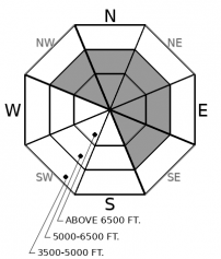
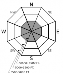
As the snow falls and the wind blows, the danger will rise. Be vigilant in the face of changing conditions. The later you are in the mountains today, the more conservative you should be. Watch for blowing snow in exposed areas near ridgelines and on cross-loaded slopes. Monitor storm totals as precipitation increases throughout the day. Shooting cracks are a red flag signaling you to dial back your terrain choices. Large, persistent slab avalanches may become possible with more loading.

2. Moderate
?
Above 6500 ft.
2. Moderate
?
5000-6500 ft.
1. Low
?
3500-5000 ft.
- 1. Low
- 2. Moderate
- 3. Considerable
- 4. High
- 5. Extreme
-
Type ?
-
Aspect/Elevation ?

-
Likelihood ?CertainVery LikelyLikelyPossible
 Unlikely
 -
Size ?HistoricVery LargeLargeSmall

Sustained winds will redistribute snow onto leeward slopes in exposed areas. Watch for cornice growth and blowing snow, these clues point to where new wind slabs are growing. The wind will have more ammo to fire as more snow accumulates this afternoon. Dense slabs over softer, weaker snow will become larger and more sensitive as you gain elevation, and later in the day. Drifts will initially be small, but by tomorrow new wind slabs may contribute to dangerous avalanche conditions.
-
Type ?
-
Aspect/Elevation ?

-
Likelihood ?CertainVery LikelyLikelyPossible
 Unlikely
 -
Size ?HistoricVery LargeLargeSmall

Early season crusts and facets have been gaining strength and have become more difficult to trigger in the past week. We expect this to change by tomorrow. Avalanches like these can be hard to predict, but 2 things are for sure: new loading will make them more reactive, and they can break 2 to 4 feet deep resulting in large slides. Choose planar slopes less than about 35 degrees. Avoid areas with variable snow cover and new wind loading. Shallow, rocky areas and convex break-overs are trigger point to watch out for. Smaller avalanches may suddenly overload the deeper weak layers.
New Year’s resolutions: 1. Go to the gym. 2. Eat healthy. 3. Make better decisions. Promises, promises. I may not be pumping iron any time soon. And I may break my second resolution by the end of the party tonight. But making better decisions is something we’re all going to have to stick to. As a powerful storm heads our way and the excitement over new snow builds, the avalanche danger will rise. Conservative decision making will become essential as we ring in the new year.
Precipitation is expected to increase throughout the day. The most intense snowfall will occur overnight. The storm track looks to favor Swan Range and Lake McDonald areas. Warm air in the upper atmosphere will cause freezing levels to rise resulting in upside-down, top-heavy storm snow. Moderate to strong winds will have ample snow to work with and will create fresh drifts on leeward terrain. New wind and storm slabs will build on top of weak surface snow. Observers from around the forecast area have found facets and surface hoar growing above a variety of hard crusts (example 1, example 2, example 3). Dense slabs on top of weak layers on top of hard sliding surfaces: an Oreo cookie of new avalanche danger. For today, instabilities should be be mostly localized to windrifted slopes, or start as sluffs that entrain the weak snow below. By later today or tonight, slabs will become more widespread.
At the bottom of the snowpack, the old, stale wafer cookie of early season crusts and facets has been gaining strength. Stability tests from the same areas have been showing improving results. Avalanches breaking on these layers last rang during the Solstice storm near the Continental Divide and the northern Whitefish Range. But they’re still down there, and new loading may wake them up where the facets are still dry and sugary.
As conditions change into this evening, so should your terrain choices. Dial it back as new loading from snow and wind increases. New avalanche problems will in the making. Old problems make crop up again under the new strain. Conservative decision making will become essential by tomorrow morning at the latest.
A WINTER WEATHER ADVISORY IS IN EFFECT UNTIL 2PM TOMORROW. An atmospheric river is expected to bring increasing precipitation beginning this afternoon. Freezing levels are expected to rise into the evening. The most intense snowfall will occur overnight. Winds will be sustained from the southwest. Temperatures fall again as a cold front passes tomorrow night.
This forecast applies only to backcountry areas outside established ski area boundaries. The forecast describes general avalanche conditions and local variations always occur. This forecast expires at midnight on the posted day unless otherwise noted. The information in this forecast is provided by the USDA Forest Service who is solely responsible for its content.


