| Saturday | Saturday Night | Sunday | |
|---|---|---|---|
| Cloud Cover: | Partly Cloudy | Mostly Cloudy | Mostly Cloudy |
| Temperatures: | 16 to 21 deg. F. | 7 to 12 deg. F. | 18 to 24 deg. F. |
| Wind Direction: | West | West | Northwest |
| Wind Speed: | 5 to 10 gusting to 20 | 10 gusting to 20 | 5 to 10 gusting to 15 |
| Snowfall: | 0" in. | 0" in. | 0" in. |
| Snow Line: | 500' | 1000' | 500' |
Flathead Range and Glacier National Park
How to read the forecast
Steep slopes where it looks most like winter are the slopes where it remains possible to trigger large avalanches that break on old snow buried deep in the snowpack. These slopes exist mostly at upper elevations, near and below ridgelines and summits, though isolated examples exist at mid elevations. Planar slopes that are sheltered from the wind and not above terrain traps can be safer alternatives. Stick to safe travel protocols that can reduce the consequences of triggering a slide.

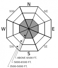
2. Moderate
?
Above 6500 ft.
1. Low
?
5000-6500 ft.
1. Low
?
3500-5000 ft.
- 1. Low
- 2. Moderate
- 3. Considerable
- 4. High
- 5. Extreme
-
Type ?
-
Aspect/Elevation ?

-
Likelihood ?CertainVery LikelyLikelyPossible
 Unlikely
 -
Size ?HistoricVery LargeLargeSmall

You can still trigger avalanches that break 2 to 4 feet deep on some steep slopes above 6000 feet. Look for - and avoid - slopes steeper than about 35 degress where convex rollovers and shallow patches of snow make it easier for a rider to collapse facets and crusts buried near the ground. These slopes tend to be rocky and prone to cross-slope winds that drift and scour snow. They're more common as you climb higher in elevation. Strict travel protocols - one at a time, partners always in sight, full set of rescue gear - can be insurance for surprises.
It's been over a week since our last significant loading event, the Solstice storm that brought new snow, rain, powerful winds, and unseasonably warm temperatures. Those conditions produced a cycle of small to large natural avalanches across the region, with large slides failing on old snow in the northern Whitefish Range, Flathead Range, and John F. Stevens Canyon. The instability didn't seem to linger long; we've had some propagation in test results but limited reports of collapses and no reports of triggered slides. There are fewer and fewer slopes where a person can trigger a large avalanche.
With that general trend, stepping out into more consequential terrain may be reasonable. Not all more-consequential-terrain is created equal, however. Beware of large, leeward slopes with variable snow depths and convexities where slope angles steepen. Wind-scouring and drifting in this terrain can create thin spots where early-season facets and crusts are buried close enough to the surface to collapse under the weight of a rider or snowmachine. It's hard to spot these thin spots without x-ray glasses, so avoiding slopes like these is a straightforward way to avoid this danger. The Flathead Range and the Lake McDonald area have more slopes like these, the peaks are higher and more exposed to wind, and most of our storms have produced avalanche cycles in these areas. Thus the higher danger rating for that zone today.
Most of the region saw a trace to 5" of fluffy snow Friday, and two minor avalanche problems may have developed in areas favored by 4" or more of fresh snow. Friday's snow fell on weak or slick surfaces like surface hoar, near-surface facets, or melt freeze crusts. It sluffed easily on steep slopes Friday and will remain sensitive to a rider's weight today. These sluffs will be harmless except on very steep slopes where they entrain cohesionless old snow and run on underlying crusts. That's a very small set of slopes - mostly chutes and couloirs in the Whitefish Range, perhaps the Swan Range. Keep this potential hazard in mind if you venture into this terrain; don't let one of these lap dogs bite you by carrying you over or into a terrain trap.
Moderate westerly winds followed Friday's snowfall. The winds were enough to blow around the low-density snow, forming thin slabs in start zones prone to collecting drifted snow. Those slabs should be sensitive to a person's weight today, since they formed on weak or slick surfaces. Slabs like these will be isolated, however. The Whitefish Range likely received enough snow to feed the winds and form slabs, and perhaps the Swan Range as well. Other areas got some wind but not enough snow.
Both of these problems may become more widespread if more snow falls Sunday.
A short-lived ridge building in from the west may bring partly cloudy skies but cold temperatures. Winds should be light with moderate gusts; they'll be westerly, though northerly winds aloft may mix down to high elevation ridges and peaks. Northwest flow Sunday may bring snow showers.
This forecast applies only to backcountry areas outside established ski area boundaries. The forecast describes general avalanche conditions and local variations always occur. This forecast expires at midnight on the posted day unless otherwise noted. The information in this forecast is provided by the USDA Forest Service who is solely responsible for its content.


