| Friday | Friday Night | Saturday | |
|---|---|---|---|
| Cloud Cover: | Mostly Cloudy | Mostly Cloudy | Mostly Clear |
| Temperatures: | 17 to 23 deg. F. | 10 to 13 deg. F. | 16 to 22 deg. F. |
| Wind Direction: | Southwest | West | West |
| Wind Speed: | 15G30 | 4G28 | 9G23 |
| Snowfall: | 1" to 2" in. | 0" in. | 0" in. |
| Snow Line: | 500' | 500' | 0' |
Whitefish Range
Swan Range
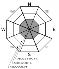
How to read the forecast
In the Whitefish and Swan Ranges, the likelihood of triggering a large avalanche is low but not impossible. Continue to approach steep slopes above 6000 feet with with caution - look for cracking, collapsing, or recent avalanche activity - if you are uncertain, select lower-angle, less-consequential terrain.

1. Low
?
Above 6500 ft.
1. Low
?
5000-6500 ft.
1. Low
?
3500-5000 ft.
- 1. Low
- 2. Moderate
- 3. Considerable
- 4. High
- 5. Extreme
-
Type ?
-
Aspect/Elevation ?

-
Likelihood ?CertainVery LikelyLikelyPossible
 Unlikely
 -
Size ?HistoricVery LargeLargeSmall

For nearly two weeks we have received consistent evidence of a stable snowpack. Thursday we received one report that demonstrates the process is not complete. This tells us there is a lurking concern for triggering an avalanche in isolated terrain features. If triggered, these weak layers could produce avalanches 2 to 4 feet deep and propagate surprisingly wide. If your decisions lead you into steep terrain above roughly 6000 ft, travel one at a time, and if your buddy gets stuck on his snowmobile in an avalanche path, let him dig himself out while you spot from a safe point.
As we reach roughly seven days since the last avalanche cycle, the chances of triggering a slide breaking on deeply buried weak layers continue to diminish. Though human-triggered avalanches are unlikely in the Whitefish and Swan Ranges and possible in the Flathead and Glacier National Park, the consequences are the same throughout the region. Triggered slides will be large enough to bury or injure you.
Throughout the region, above roughly 6000 feet, we can all agree that there is a poor snowpack structure with some areas weaker than others. Our last storm deposited a slab on top of a series of crusts and facets left from October and November. These weak layers are more widely distributed in the Flathead Range and Glacier National Park, and less widespread in the Whitefish and Swan Ranges. The distribution is the key factor in today’s danger ratings, making large avalanches more of a concern in Glacier National Park and the Flathead Range. A snowpit from Thursday shows continued concern for the potential for large avalanches.
Thursday, in the northern Whitefish Range, Zach was not surprised to find recent avalanche activity that likely occurred on December 20th. He was surprised to find was propagating results in extended column tests. With this information, he and his partner dialed back their terrain choices, as noted in the video below. Other riders reported no signs of instability in the southern Whitefish Range. Near Marias Pass, I found a weak but stable snowpack. This variability demonstrates the importance of carefully assessing conditions where you’re riding before committing yourself to it. Even in low danger, unstable snow on isolated terrain features can still be found.
Interestingly, both reports from the Whitefish range described 3 to 5 inches of recent snow topped with large surface hoar and sitting on top of yet another crust (Christmas Eve crust). The recent snow has already faceted. The surface, facets and Christmas Eve crust could soon become the next potential failure plane when buried.
Today expect lingering showers with the potential to pick up T-3 inches of snow in favored areas. Winds will be moderate out of the SW gusting to 35 mph. Temperatures will be in the low 20s.
This forecast applies only to backcountry areas outside established ski area boundaries. The forecast describes general avalanche conditions and local variations always occur. This forecast expires at midnight on the posted day unless otherwise noted. The information in this forecast is provided by the USDA Forest Service who is solely responsible for its content.


