| Thursday | Thursday Night | Friday | |
|---|---|---|---|
| Cloud Cover: | Partly Cloudy | Mostly Cloudy | Mostly Cloudy |
| Temperatures: | 17 to 23 deg. F. | 9 to 15 deg. F. | 17 to 23 deg. F. |
| Wind Direction: | Southwest | Southwest | Southwest |
| Wind Speed: | 10G25 | 15G35 | 20G35 |
| Snowfall: | 0" in. | 0" in. | 0" to 2" in. |
| Snow Line: | 500' | 500' | 500' |
Flathead Range and Glacier National Park
How to read the forecast
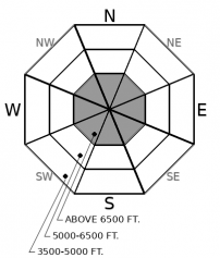
In Glacier National Park and the Flathead Range, it remains possible to trigger a large avalanche breaking deep within the snowpack. Avalanche activity from this weekend that left debris piles up to 20 feet deep should be a reminder to approach each slope with a high level of suspicion. Travel one at a time, and if your uncertainty grows, choose simpler terrain away from alpine start zones.

2. Moderate
?
Above 6500 ft.
1. Low
?
5000-6500 ft.
1. Low
?
3500-5000 ft.
- 1. Low
- 2. Moderate
- 3. Considerable
- 4. High
- 5. Extreme
-
Type ?
-
Aspect/Elevation ?

-
Likelihood ?CertainVery LikelyLikelyPossible
 Unlikely
 -
Size ?HistoricVery LargeLargeSmall

Avalanches breaking 2 to 4 feet deep and surprisingly wide, remain possible to trigger in the Flathead and Glacier National Park region. Persistent slab avalanches are notorious for being remotely triggered and breaking further upslope than other, more predictable avalanches. Though it has been three days since the last report of any instability, take cation while approaching any avalanche terrain above roughly 6000 feet. Avoid likely trigger points, such as shallow rocky outcroppings or breakovers, where you are more likely to add stress to deeply buried weak layers. Select planar slopes and travel one at a time through avalanche terrain above 6000 feet.
As Santa Claus made his rounds throughout our region, he left us with no new reports of avalanches or instabilities. No news could be for one of two reasons: one, our snowpack is gaining strength, or two, everyone stayed home and proceeded to overeat and enjoy time with friends and family. I see it as a combination of the two.
As we near six days since the last storm cycle, persistent weak layers from October and November are more stubborn, unpredictable, and may require large loads, or perhaps just the wrong thin spot, to be triggered. Though the snowpack is gaining strength, weak layers have still shown their colors as recently as Monday’s propagating snowpit tests, and reports of very large (D3) avalanches coming out of the Flathead/GNP region that likely ran during Friday’s storm. Signs of instabilities have been reaching down to about 6000 feet, as shown in these visual aids, which blurs the mid and upper elevation bands. These, to me, are signs to approach any avalanche terrain in Flathead and Glacier National Park with a great deal of respect.
Since the Whitefish and Swan ranges are warmer, lower in elevation, less wind-exposed, and held a less continuous snowpack early season, persistent avalanche problems involving old snow near the ground (like we have now) haven’t been as active. It has been almost two weeks since any report of instability involving persistent weak layers in the Whitefish or Swan Ranges. Paired with quiet weather this week which has given the snowpack more time to adjust, this is why we are rating the danger Low in these ranges. Remember, Low danger does not mean no danger. Carefully assess each slope before committing and watch for isolated instabilities.
Today expect mild weather and partly cloudy skies. Winds will be light and become gustier into the afternoon and evening hours. Temperatures will be in the high teens and low 20s.
This forecast applies only to backcountry areas outside established ski area boundaries. The forecast describes general avalanche conditions and local variations always occur. This forecast expires at midnight on the posted day unless otherwise noted. The information in this forecast is provided by the USDA Forest Service who is solely responsible for its content.


