| Wednesday | Wednesday Night | Thursday | |
|---|---|---|---|
| Cloud Cover: | Partly Cloudy | Partly Cloudy | Mostly Cloudy |
| Temperatures: | 25 to 30 deg. F. | 13 to 18 deg. F. | 20 to 27 deg. F. |
| Wind Direction: | Southwest | Southwest | Southwest |
| Wind Speed: | 15G35 | 12G25 | 20G35 |
| Snowfall: | 0" in. | 0" in. | 1" to 4" in. |
| Snow Line: | 2000' | 2000' | 1500' |
Flathead Range and Glacier National Park
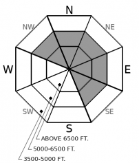
How to read the forecast
As the snowpack continues to gain strength from the last load of snow, mixed messages of instability persist. Though only a handful of avalanche reports have come in since the recent storm, whumpfing collapses continue to show signs that weak layers that have yet to adjust. Recent collapses highlight the lingering threat of triggering a slab up to several feet thick in steep terrain as you transition near and into upper elevations.

2. Moderate
?
Above 6500 ft.
2. Moderate
?
5000-6500 ft.
1. Low
?
3500-5000 ft.
- 1. Low
- 2. Moderate
- 3. Considerable
- 4. High
- 5. Extreme
-
Type ?
-
Aspect/Elevation ?

-
Likelihood ?CertainVery LikelyLikelyPossible
 Unlikely
 -
Size ?HistoricVery LargeLargeSmall

We are not in the clear yet. Triggering slabs 3 feet thick or more is still a concern on several week layers that formed in November. These layers have shown their colors the most near and above roughly 6500 feet. Whumpfing collapses have led the charge in signs of instability with shooting cracks and recent avalanches coming in second and third. If triggered, you may be surprised by how wide the avalanche propagates and how difficult it will be to escape from. The safest place to enjoy skiing and riding is at middle elevation terrain. If your snowpack assessments give you the green light to play in upper elevations, choose planar slopes away from rocky outcroppings to reduce your risk.
-
Type ?
-
Aspect/Elevation ?

-
Likelihood ?CertainVery LikelyLikelyPossible
 Unlikely
 -
Size ?HistoricVery LargeLargeSmall

Sustained moderate winds over the past 48 hours have formed pockets of wind loaded snow near ridgelines and in cross-loaded features below. Riders yesterday were able to trigger small wind slabs that were harmless in size, but could have proved more consequential if pushed into a terrain trap. These stubborn slabs are likely to be 6 to 12 inches deep. Seek wind-sheltered terrain if you see blowing snow, fresh cornice formation, or pillowy or drifted looking surface conditions.
If your travels take you to the upper elevations today, there are a few things to be wary of. Yesterday riders found small but reactive wind slabs on rollovers and below a leeward ridgeline. Although wind slabs today are likely to be stubborn and small, they could be consequential if you get caught above a cliff, or a band of trees.
Looking back, we have an onslaught of befuddling details regarding the strength of the snowpack. Our forecaster conversations in the past few days have revolved around the surprising lack of avalanche activity from the last storm and how it appears that the snow is gaining strength and stabilizing. Then WHUMPF! A massive collapse with a shooting crack occurs in our snowpit yesterday. Conflicting data! What do we do with this information?
Persistent slab avalanches are notorious for being difficult to assess, predict, and manage. Handling this type of problem ultimately boils down to conservative, intentional decisions on where to put yourself on the slope. During a low likelihood, deep and stubborn situation like right now, one strategy is to choose planar slopes and avoid rock features where the snowpack is thinner and more likely to collapse a weak layer, as we did in our snowpit yesterday. Another way is to choose terrain at mid-elevations where the slabs and weak layers are less developed and more anchored by vegetation. Underbrush disrupts the weak layer being able to propagate to a critical size and cause an avalanche. Also, as basic as it may seem, travel one at a time. It is easier for two rescuers to dig one person out of the snow than it is for one rescuer to dig two people out of the snow.
High pressure sets in over the region, leaving us with clear and dry conditions. Temperatures will be in the mid to upper 20s. Winds will be light with gusts into the moderate category out of the southwest. Looking ahead, we have a healthy storm on tap that could bring two feet of mountain snow starting Thursday.
This forecast applies only to backcountry areas outside established ski area boundaries. The forecast describes general avalanche conditions and local variations always occur. This forecast expires at midnight on the posted day unless otherwise noted. The information in this forecast is provided by the USDA Forest Service who is solely responsible for its content.


