| Wednesday | Wednesday Night | Thursday | |
|---|---|---|---|
| Cloud Cover: | Mostly Cloudy | Mostly Cloudy | Overcast |
| Temperatures: | 23 to 28 deg. F. | 19 to 23 deg. F. | 27 to 33 deg. F. |
| Wind Direction: | Southwest | Southwest | Southwest |
| Wind Speed: | 17G31 | 18G37 | 25G48 |
| Snowfall: | 3" to 5" in. | 3" to 5" in. | 4" to 6" in. |
| Snow Line: | 2500' | 2500' | 3000' |
Whitefish Range
Swan Range
How to read the forecast
Increasing southwest winds may produce sensitive wind slabs on leeward slopes. If you see cornices developing or snow blowing off ridgelines, seek sheltered, low angle terrain. Riders continue to report large, whumpfing collapses from mid and upper elevation slopes. Those collapses are clear evidence that it remains possible to trigger large avalanches that break on buried persistent weak layers.

2. Moderate
?
Above 6500 ft.
2. Moderate
?
5000-6500 ft.
1. Low
?
3500-5000 ft.
- 1. Low
- 2. Moderate
- 3. Considerable
- 4. High
- 5. Extreme
-
Type ?
-
Aspect/Elevation ?

-
Likelihood ?CertainVery LikelyLikelyPossible
 Unlikely
 -
Size ?HistoricVery LargeLargeSmall

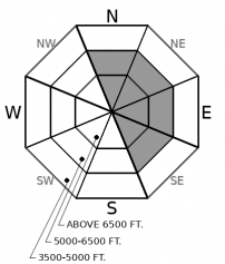
Today, southwesterly winds are forecast to average 15-20 MPH, which makes for ideal conditions to drift snow into hard slabs on north- to east-facing slopes near ridgelines. Drifted snow may also cross-load gullies below ridges. Slabs that form today may be one to two feet thick, so triggering one can produce dangerous avalanches large enough to bury or injure a person. Managing this problem can be straightforward; seek out sheltered terrain when you see freshly formed wind slabs, which may be pillow-shaped and sound hollow. Avoid slopes below ridges where you see overhanging cornices and blowing snow.
-
Type ?
-
Aspect/Elevation ?

-
Likelihood ?CertainVery LikelyLikelyPossible
 Unlikely
 -
Size ?HistoricVery LargeLargeSmall

Riders continue to report whumpfing collapses at mid and upper elevations. These collapses are clear signs that you can still trigger avalanches that break 1 to 3 feet deep on buried surface hoar or facets around crusts in steep, mid- and upper-elevation slopes. These weak layers may be most sensitive to the weight of a rider on steep, northerly and easterly slopes, where today’s winds are drifting snow and adding load. Triggered slides can propagate long distances and break further up-slope than you expect. Collapsing or whumpfing, shooting cracks, and recent avalanches are all signs to avoid being on or below steep slopes.
The avalanche hazard may increase as winds average in the upper teens with gusts as strong as 40 mph. Although we expect little snow to fall today, we do have snow available to transport. This settled, denser snow sitting on the surface is likely to leave hard wind slabs on lee facing terrain. Because some areas of the forecast region received up to 12 inches of snow in the last storm, these winds could produce avalanches up to two feet thick. While most triggered wind slabs will fail at the interface with older snow, some may step down and break on one of our buried persistent week layers, producing larger, more dangerous avalanches.
There is no question about our poor snowpack structure. Buried weak layers, such as surface hoar or the late November crust, may activate with the additional weight and produce large avalanches. Observations came in yesterday of two different parties experiencing collapses in terrain that they had previously ridden (one report here). Both parties were managing their slope angle, so these collapses did not produce avalanches. These collpases demonstrate the tricky, unpredictable nature of persistent slab avalanches. Remember, previous tracks do not mean stable snow!
As we move forward, managing the terrain will be essential if we see the wind speeds that are forecast. As the avalanche hazard becomes more complex, the decisions become more simple. Stick to slopes less than 30 degrees if you feel collapses, hear whumpfs, or see shooting cracks. Watch for blowing snow and keep an eye on new snow accumulations. If you are in an area that has received 3-6 inches, seek out the low angle, sheltered terrain. These are tell-all signs that you have the recipe for an avalanche.
We recently installed a new wind and temperature station on Mt. Aeneas in the Swan Range. The link to the data is here, and we will be incorporating it into our weather station maps and tables soon. This is another great resource for trip planning and assessing avalanche conditions.
Today's wind speeds will reach 15 to 20 mph, with gusts as strong as 40 mph. Expect lingering snow showers throughout the region. The Swan Range will be favored with 3-6 inches of new snow. Temperatures will be in the upper 20s to low 30s.
This forecast applies only to backcountry areas outside established ski area boundaries. The forecast describes general avalanche conditions and local variations always occur. This forecast expires at midnight on the posted day unless otherwise noted. The information in this forecast is provided by the USDA Forest Service who is solely responsible for its content.


