Whitefish Range
Swan Range
Flathead Range and Glacier National Park
How to read the forecast

No Rating
?
Above 6500 ft.
No Rating
?
5000-6500 ft.
No Rating
?
3500-5000 ft.
-
Type ?
-
Aspect/Elevation ?

-
Size ?HistoricVery LargeLargeSmall

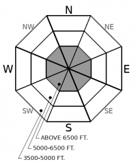
Watch for pockets of drifted snow this week from several generations of changing wind directions. These wind slabs may be hard and up to a foot thick in upper elevations. Although relatively small, they can produce serious consequence if pushed into rocks, trees, or gullies. Winds have been southwesterly early in the week, and will shift to the east Tuesday evening. Wednesday brings a peak in winds and snowfall; expect slabs to be most reactive during this time. Drifted slabs will be found on leeward and cross loaded terrain. Avoid these wind slabs by riding in wind sheltered locations.
-
Type ?
-
Aspect/Elevation ?

-
Size ?HistoricVery LargeLargeSmall

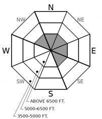
We have yet to hear about any more activity since the report came in on Friday about very large (D3) avalanches with crowns 3 to 5 feet deep. This problem most likely is lurking on cold slopes at upper elevations. Without substantial loading in the forecast this week, it is unlikely but not impossible to trigger a dangerously large avalanche with the current snowpack structure at high elevations. Collapsing or shooting cracks are immediate signs to seek lower angle terrain away from these alpine start zones.
As a small system grazed our region this weekend it produced moderate to strong southwesterly winds, and a trace to two inches of snow. This has created shallow wind slabs on leeward and cross loaded terrain facing north and east. Prior to this event we were able to gain observations from both FAC staff and public. We found a buffet of crusts and facets, as well as some newly developed surface hoar as shown in this observation.
As this next system approaches from the Northeast Tuesday evening, it delivers a heavy punch of winds and 1-3 inches of snow. Marias Pass appears to be favored with a possibility of 6 inches of snow. This new snow, accompanied by strong northeasterly winds, will leave pockets of hard wind slabs on south through west aspects. As you make your approach, take the time to see which direction snow is being blown around and where it is being deposited. If you find yourself moving across terrain that has fresh pillows, it may be time to step back.
Last week, a large precipitation event produced several very large (D3) avalanches in Glacier National Park, as shown here. We are returning to a quieter weather pattern now with light amounts of precipitation and winds expected to strip the new snow from suspect start zone. Under our current weather patterns, persistent slabs are becoming harder to trigger. However, we are in early season operations and still have limited observations from the field. Take the time to assess the snowpack structure if you are venturing into high, alpine terrain.
This forecast applies only to backcountry areas outside established ski area boundaries. The forecast describes general avalanche conditions and local variations always occur. This forecast expires at midnight on the posted day unless otherwise noted. The information in this forecast is provided by the USDA Forest Service who is solely responsible for its content.
Call
Contact
In Partnership With

In Partnership With


