| Monday | Monday Night | Tuesday | |
|---|---|---|---|
| Cloud Cover: | Mostly Cloudy | Mostly Cloudy | |
| Temperatures: | deg. F. | 27 to 31 deg. F. | 30 to 35 deg. F. |
| Wind Direction: | East | Northeast | |
| Wind Speed: | 0G21 | 19G39 | |
| Snowfall: | in. | 1" in. | 6" to 7" in. |
| Snow Line: | 5500' | 4500' |
Whitefish Range
Swan Range
Flathead Range and Glacier National Park
How to read the forecast
The risk of triggering an avalanche will rise during a winter-like storm Tuesday through Wednesday. The hazard will most likely be confined to higher elevation terrain with enough snow coverage to ski or ride. Track snow totals and watch for wind drifted slabs forming on leeward slopes. The early season snowpack is thin and runs out as you lose elevation. Avalanches can drag you over and into rocks, stumps, or other obstacles increasing the consequences of getting caught.

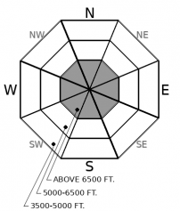
No Rating
?
Above 6500 ft.
No Rating
?
5000-6500 ft.
No Rating
?
3500-5000 ft.
-
Type ?
-
Aspect/Elevation ?

-
Size ?HistoricVery LargeLargeSmall

6 to 12+ inches of snow are expected between Tuesday and Wednesday. Winds could be strong enough to transport snow across favored, alpine terrain. Storm slabs and drifts can form in gullies, alpine bowls, and around ridgelines as snow piles up. On leeward terrain, watch for deeper, and more dangerous, slabs of drifted snow. Cracks shooting through the snow in front of you is a sure sign of instability.
Up to an inch of water fell Sunday, wetting down the snow to above 7,000’. Several inches of thick glop stuck above the rain line. Under the goo, the base of our snowpack consisted of a series of crusts and facets. New snow Tuesday will fall on crusts or moist surfaces. Gusty winds may deposit dense drifts over lower density snow into Wednesday. Watch for blowing snow. Shooting cracks in new snow, especially on steep leeward terrain, will be the biggest sign of instability. Storm and wind slabs are usually most sensitive during or immediately following a storm. High pressure, calmer weather, and colder temps build over our region Wednesday and Thursday. An active pattern looks to return by the end of the weekend with the chance for precipitation continuing through much of next week.
This is an early season snowpack update. The FAC will continue to monitor conditions through the fall and post updates as conditions warrant. We anticipate daily forecasts and full operations to begin in December.
The NWS is producing automated mountain weather forecasts during the fall season here. We will be producing weather forecasts to accompany daily avalanche forecasts during regular operations.
This forecast applies only to backcountry areas outside established ski area boundaries. The forecast describes general avalanche conditions and local variations always occur. This forecast expires at midnight on the posted day unless otherwise noted. The information in this forecast is provided by the USDA Forest Service who is solely responsible for its content.


