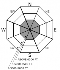
Whitefish Range
Swan Range
Flathead Range and Glacier National Park
How to read the forecast
If there's enough snow to ride, there's a enough snow to slide. Avalanche hazards so far this season are generally localized to high elevation terrain with smooth and continous snow coverage. With a thin early season snowpack, slabs breaking in new or windblown snow can produce harsh consequences if they drag you over rocks, cliffs, or stumps. Pay attention to new snow, windloading amounts, and underlying weak layers if you are traveling on steep, snow covered terrain.

No Rating
?
Above 6500 ft.
No Rating
?
5000-6500 ft.
No Rating
?
3500-5000 ft.
-
Type ?
-
Aspect/Elevation ?

-
Size ?HistoricVery LargeLargeSmall

Be wary of reactive slab avalanches that develop on high elevation terrain from new snow and wind. Early season storms have left a patchwork of weak snow on the ground that will not bond well to accumulating snow above it. You are most likely to find unstable slabs involving recent snow in windloaded terrain or in northerly facing alpine cirques or bowls - these are the terrain features that have the most continous and layered snow coverage right now. New snow accumulating on brush, talus, or vegetation is not much of a concern, but be cautious of any steep terrain where the snow coverage is smooth and collecting on older, weak layers or crusts. Shooting cracks or collapses in the snow are signs of instability warning you to choose lower angle terrain.
Several early season storms in September and early October have left a thin, rotting snowpack on some high elevation terrain (See this observation and this observation). Unless preceding rain destroys these old snow layers, the lingering crusts and faceted snow will not bond well with slabs that form above it. The easternmost portion of our forecast area has been favored by early season storms: it has the most continous snow coverage right now across all aspects and spans across more elevation bands. The westernmost mountain ranges (the Swan and Whitefish Ranges) have thin snow coverage lingering on some shaded alpine cirques, bowls, and gullies. As we return to an active, snowy pattern this weekend, terrain harboring old snow layers is most suspect for avalanche hazards. If you are venturing into avalanche terrain, monitor the amounts of new snow, windloading, and most importantly, what kind of surface it is accumulating on. Expect newly formed storm slabs or wind slabs to fail easily if they form on top of faceted snow layers. These instabilities will persist for some time. Snow that accumulates on bare ground or is well anchored by brush or talus is not much of a concern. If the snow surface is smooth and planar, treat it with suspicion. Even though most early season avalanches are relatively small, they often result in season ending injuries as they drag you over rocks, cliffs, or thin snow coverage. If you plan to travel on snow covered slopes, pay attention for obvious signs of instability (blowing snow, cracking snow, collapses, etc), bring avalanche rescue gear (beacon, probe, shovel), and wearing a helmet is a good idea too.
The FAC will monitor conditions through the fall and post updates as conditions warrant. We anticipate daily forecasts and full operations to begin in December.
Now is the time to get your gear dialed and brush up on your avalanche knowledge. The 2019 Northern Rockies Snow and Avalanche Workshop has a great lineup of presentations, vendor booths, raffles, and an all-around good time. The event is November 16th, 2019...all the details are here. Registration is open! Stay tuned for our upcoming avalanche class schedule later this fall.
The NWS is producing automated mountain weather forecasts during the fall season here. We will be producing weather forecasts to accompany daily avalanche forecasts during regular operations.
This forecast applies only to backcountry areas outside established ski area boundaries. The forecast describes general avalanche conditions and local variations always occur. This forecast expires at midnight on the posted day unless otherwise noted. The information in this forecast is provided by the USDA Forest Service who is solely responsible for its content.
Call
Contact
In Partnership With

In Partnership With


