| Monday | Monday Night | Tuesday | |
|---|---|---|---|
| Cloud Cover: | Decreasing clouds | Increasing clouds | Mostly Cloudy |
| Temperatures: | 40 to 45 deg. F. | 27 to 32 deg. F. | 36 to 41 deg. F. |
| Wind Direction: | South | South | Southwest |
| Wind Speed: | 0 to 5 | 0 to 10, G20 | 10 to 20, G35 |
| Snowfall: | 0" in. | 0" in. | 1" in. |
| Snow Line: | 5000' | 5000' | 4500' |
Whitefish Range
Swan Range
Flathead Range and Glacier National Park
How to read the forecast
We aren't out of the woods yet! An unintentionally triggered wet slab just north of our forecast area and several skier triggered wet loose avalanches yesterday highlight our ongoing frustrations with wet instabilities. High elevations are holding the coldest, safest snow. Move off of steep terrain once the snowpack turns mushy or you see rollerballs and pinwheels.

1. Low
?
Above 6500 ft.
2. Moderate
?
5000-6500 ft.
2. Moderate
?
3500-5000 ft.
- 1. Low
- 2. Moderate
- 3. Considerable
- 4. High
- 5. Extreme
-
Type ?
-
Aspect/Elevation ?
-
Likelihood ?CertainVery LikelyLikelyPossible
 Unlikely
 -
Size ?HistoricVery LargeLargeSmall

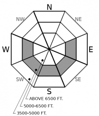
Although wet slab activity has diminished since Friday, the snowpack is still not refreezing at night under cloudy skies. Yesterday, a skier near Fernie unintentionally triggered a destructive wet slab that broke trees. The potential for human or natural triggered wet slabs lingers on the sunniest, hottest aspects, where water has been channeling through weak layers for several days. Wet slabs are difficult to assess and even more difficult to survive if you get caught in one. Choose routes that reduce your exposure on and below suspect aspects before the day gets too warm and the snowpack turns to mush. If you step off your skis or sled and sink to your waist, you have outstayed your welcome in steep terrain.
-
Type ?
-
Aspect/Elevation ?
-
Likelihood ?CertainVery LikelyLikelyPossible
 Unlikely
 -
Size ?HistoricVery LargeLargeSmall

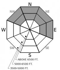
As the snow surface warms up, the threat of point release avalanches gouging through the snowpack will increase. Yesterday skiers triggered several wet loose avalanches that entrained the whole season's snowpack. The problem is expected to be most active on shaded, northerly aspects, where the snow is just now transitioning to wet. Loose wet sluffs give obvious surface clues: look for pinwheels, rollerballs, or shin-deep slush as a warning sign to stay away from terrain traps and gullies.
Wet snow, wet snow, wet snow. The forecast sounds like a broken record but conditions are changing. Rather than the blazing hot, sunny days of last week, we are seeing cloudier and cooler weather this week. This has important implications, so follow along. Sunny aspects got scorched last week, producing an impressive cycle of wet slabs and wet loose avalanches breaking on every imaginable layer in the snowpack, most commonly the ground. The snow surface on southerly and westerly aspects has been worked over, and is now enjoying a respite from the heat under cooler, cloudier weather. Surface instabilities are getting harder to trigger (but not impossible). However, cloudy skies are preventing a refreeze at night and meltwater continues to travel through the snowpack. The odds of a wet slab have significantly diminished since last week, but they haven't gone away just yet. Yesterday a skier near Fernie accidentally triggered a wet slab on an east aspect at 5,000'. The problem has been most active at mid-elevations on southeast through west-facing terrain: the slopes that got hottest and had existing poor structure.
Northerly terrain has remained mostly dry throughout last week, thanks to shade and clear skies. Wet slabs are not a concern on those aspects yet, but the snow surface is changing now. Clouds are now creating a greenhouse effect that is warming the snow surface on northerly aspects. Yesterday, our field teams noted due north facing terrain becoming active with wet loose activity. With another relatively warm, cloudy night last night, expect more of the same today. These wet loose slides could run naturally or will be easily triggered, and could gouge to the ground just like we saw last week on southerly aspects.
It is tricky conditions right now. Low likelihood/high consequence wet slab concerns on one half of the compass rose, increasingly active wet loose concerns on the other. Fortunately, high elevations are staying cooler now and your best chance of finding good snow and safe riding is going into the alpine. Weather forecasts are calling for clearing skies through the day and improved visibility - a good time to venture up high. So start early, climb high, and choose an egress route that manages warmer, sloppier snow on your way back to the car this afternoon.
EDUCATION: The Scoop on Spring Touring: Curious about spring snow and safe travel techniques? This is the talk for you. Join FAC Lead Forecaster Blase Reardon for a FREE one hour talk on spring conditions in the Flathead. The talk begins at 6:30 p.m. Thursday, April 11th at Rocky Mountain Outfitters in Kalispell. That evening is also a community night for the Friends of the Flathead Avalanche Center at Sweet Peaks in Kalispell. Stop by for a sweet treat and then head down the street to get the scoop on spring conditions.
Cloudy skies this morning will give way to clearing skies this afternoon under seasonal temperatures. Tomorrow's disturbance brings a few showers and increased winds.
This forecast applies only to backcountry areas outside established ski area boundaries. The forecast describes general avalanche conditions and local variations always occur. This forecast expires at midnight on the posted day unless otherwise noted. The information in this forecast is provided by the USDA Forest Service who is solely responsible for its content.


