| Sunday | Sunday Night | Monday | |
|---|---|---|---|
| Cloud Cover: | Mostly cloudy | Mostly Cloudy | Partly Cloudy |
| Temperatures: | 35 to 45 deg. F. | 25 to 30 deg. F. | 35 to 45 deg. F. |
| Wind Direction: | North | North | Southwest |
| Wind Speed: | 5 to 10, gusting to 25 | 5 to 10, gusting to 15 | 5 to 10, gusting to 20 |
| Snowfall: | 0" in. | 0" in. | 0 in. |
| Snow Line: | 5500' | 5000' | 5000' |
Whitefish Range
Swan Range
Flathead Range and Glacier National Park
How to read the forecast
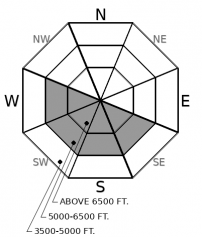
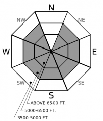
Seasonable weather and an adjusting snowpack will lead to another day of diminishing wet avalanche activity. Despite improving stability, the potential remains for a natural or human triggered slide. A poor refreeze overnight may create sloppy conditions requiring moving to a shadier aspect or low-angle terrain. Steer around steep sunny slopes as they warm. Due north aspects still hold quality safer snow.

2. Moderate
?
Above 6500 ft.
2. Moderate
?
5000-6500 ft.
1. Low
?
3500-5000 ft.
- 1. Low
- 2. Moderate
- 3. Considerable
- 4. High
- 5. Extreme
-
Type ?
-
Aspect/Elevation ?
-
Likelihood ?CertainVery LikelyLikelyPossible
 Unlikely
 -
Size ?HistoricVery LargeLargeSmall

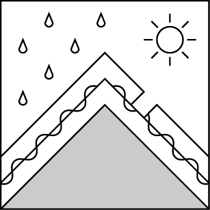
Cooler temperatures have returned to our area slowing down the production of meltwater. No observations of wet slabs were reported yesterday. Although stability is improving, weak layers deep in the snowpack have been lubricated by this week's warming and potential remains for a natural or human triggered wet slab. Resulting slides could be very large and destructive. This is a difficult problem to assess and avoiding suspect aspects is the best strategy. Steer around steep sunny slopes as they warm, especially if the sun appears more than forecast. Pay attention to overhead hazards while traveling on or below avalanche terrain.
-
Type ?
-
Aspect/Elevation ?
-
Likelihood ?CertainVery LikelyLikelyPossible
 Unlikely
 -
Size ?HistoricVery LargeLargeSmall

The recent heatwave produced an impressive loose wet avalanche cycle. The snow surface has mostly adjusted to the prolonged warming and melting with diminishing activity reported. A poor refreeze last night makes natural and triggered slides a possibility today. Slides have the potential to gouge into the snowpack and produce surprisingly large destructive debris. Terrain traps and long-running gullies magnify the consequences of these slides. Move to a shadier aspect when you find yourself or machine sinking into sloppy snow.
Seasonable weather is allowing our snowpack to adjust to last weeks heat wave heart punch. Wet avalanche activity peaked mid-week with diminishing reports of slides since Friday. Our observation page highlights an impressive cycle that produced extensive wet slab and wet loose avalanches that involved the entire season's snowpack in some areas. To find enjoyable and safe conditions on sunny aspects requires a solid overnight refreeze. Friday night produced the first refreeze in a week but warm temperatures last night did not. This morning, expect to find a softer snow surface at all elevations but especially under tree canopies. Alpine slopes receiving wind will stay frozen and safer longer. Today's mostly cloudy conditions will limit solar input but the strong March sun requires minimal time to soften slopes and increase the hazard. Reports continue to filter in of enjoyable faceted powder on true north aspects which offer a much more enjoyable and safer experience.
EDUCATION: The Scoop on Spring Touring: Curious about spring snow and safe travel techniques? This is the talk for you. Join FAC Lead Forecaster Blase Reardon for a FREE one hour talk on spring conditions in the Flathead. The talk begins at 6:30 p.m. Thursday, April 11th at Rocky Mountain Outfitters in Kalispell. That evening is also a community night for the Friends of the Flathead Avalanche Center at Sweet Peaks in Kalispell. Stop by for a sweet treat and then head down the street to get the scoop on spring conditions.
Cloudy cooler weather moves into our area with a chance of late afternoon showers. Tomorrow, expect a brief break in the clouds before unsettled weather moves in for the remainder of the work week.
This forecast applies only to backcountry areas outside established ski area boundaries. The forecast describes general avalanche conditions and local variations always occur. This forecast expires at midnight on the posted day unless otherwise noted. The information in this forecast is provided by the USDA Forest Service who is solely responsible for its content.


