| Tuesday | Tuesday Night | Wednesday | |
|---|---|---|---|
| Cloud Cover: | Mostly Clear | Mostly Clear | Mostly Clear |
| Temperatures: | 44 to 48 deg. F. | 25 to 30 deg. F. | 45 to 50 deg. F. |
| Wind Direction: | Southwest | West | West |
| Wind Speed: | 0 to 5 | 0 to 5 | 0 to 5 |
| Snowfall: | 0 in. | 0 in. | 0 in. |
| Snow Line: | 5000 | 5000 | 5000 |
Whitefish Range
Swan Range
Flathead Range and Glacier National Park
How to read the forecast
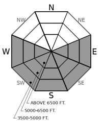
The intensifying heatwave will lead to another day of wet avalanche activity. Large, dangerous wet loose slides have occurred each of the past three days. While the snowpack is generally stable this morning, the avalanche danger will rise with prolonged sunshine. Unsupportable, mashed potato-like snow is a clear sign of instability. Safer and higher quality snow can be found on shaded slopes.

2. Moderate
?
Above 6500 ft.
2. Moderate
?
5000-6500 ft.
2. Moderate
?
3500-5000 ft.
- 1. Low
- 2. Moderate
- 3. Considerable
- 4. High
- 5. Extreme
-
Type ?
-
Aspect/Elevation ?

-
Likelihood ?CertainVery LikelyLikelyPossible
 Unlikely
 -
Size ?HistoricVery LargeLargeSmall

Ridgeline weather stations have reported at or above freezing temperatures since yesterday morning. Above normal temperatures and sunshine, will break down the thin surface crust leading to wet snow instabilities. Numerous large destructive wet avalanches have run full path the past 3 days. Avalanches have the potential to gouge into the snowpack and remove most, if not all, of the snow cover. They will be most dangerous above terrain traps and in long-running gullies on sunny aspects. Move to shaded terrain as the surface crust breaks down. Avoid traveling on or below steep sunny slopes as the day progresses.
-
Type ?
-
Aspect/Elevation ?

-
Likelihood ?CertainVery LikelyLikelyPossible
 Unlikely
 -
Size ?HistoricVery LargeLargeSmall

With warming temperatures comes the threat of larger more destructive slides. Saturday, I found a Persistent Slab avalanche in Skiumah Creek that happened earlier that week. The slide failed on the February 2 crust, was a whopping 60" deep, and may have been initiated by an icefall or meltwater from increasing temperatures. This avalanche initiated in steep rocky terrain which harbored a thin snowpack; the exact terrain that we have warned about all season. Terrain management is the easiest way to deal with this complex problem. Avoid steep convex slopes or rocky terrain harboring a thin variable snowpack with planar well-supported terrain a better choice.
We are in the midst of an impressive wet avalanche cycle with large slides reported each of the past 3 days. In the Flathead Range Sunday, I noted a widespread cycle in Rescue Creek with Blase noting similar results on Essex Mountain. Guy and Zach traveled to the northern Whitefish Range Monday where they observed large destructive avalanches which failed over the weekend. BNSF Snow Safety reported dozens of small to large wet slides in John F Stevens Canyon. Yesterday afternoon a slide covered the groomed Canyon Creek snowmobile trail with another covering the Hay Creek road in the northern Whitefish Range.
Areas which harbor a thinner weaker snowpack, such as the northern Whitefish Range and John F Stevens Canyon, are most susceptible to larger more dangerous slides. The cold February weather deteriorated the near-surface snow resulting in a weak faceted snowpack at mid and low elevations. Wet slides originating from above have been gouging down into this weak snow and removing most, if not all, of the season's snowpack. Many of these slides are running full path and depositing impressive debris piles in the valley floor.
Today will be the fourth day of warm sunny weather which is slowly weakening large cornices throughout our area. These behemoths take a lot of warming to weaken, but once warmed they retain heat and require an extended period to strengthen. Cornice fall has the potential to trigger deep weak layers in the pack such as the Feb 2 (Groundhog Crust) resulting in a very large destructive avalanche.
Managing the wet loose avalanche problem is straightforward and involves following the progression of the sun from east to west on sunny aspects. The snow on southerly slopes is currently poor quality and we recommend enjoying the old settled powder on shaded aspects to avoid the Loose Wet avalanche problem.
High pressure continues to build with mountain temperatures slightly above average today and Wednesday.
This forecast applies only to backcountry areas outside established ski area boundaries. The forecast describes general avalanche conditions and local variations always occur. This forecast expires at midnight on the posted day unless otherwise noted. The information in this forecast is provided by the USDA Forest Service who is solely responsible for its content.


