| Monday | Monday Night | Tuesday | |
|---|---|---|---|
| Cloud Cover: | Mostly Clear | Mostly Clear | Mostly Clear |
| Temperatures: | 33 to 37 deg. F. | 15 to 21 deg. F. | 38 to 43 deg. F. |
| Wind Direction: | Southwest | West | West |
| Wind Speed: | 0 to 5 | 0 to 5 | 0 to 5 |
| Snowfall: | 0 in. | 0 in. | 0 in. |
| Snow Line: | 4000 | 4000 | 4000 |
Whitefish Range
Swan Range
Flathead Range and Glacier National Park
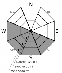
How to read the forecast
Another day of warm sunny conditions will increase the threat of wet avalanches. Large, dangerous wet loose slides occurred yesterday and will become more widespread today. While the snowpack is generally stable this morning, the avalanche danger will rise with prolonged sunshine. Unsupportable, mushy snow or rollerballs are signs to move to shaded or lower angled slopes. Safer and higher quality snow can be found on shaded slopes.

2. Moderate
?
Above 6500 ft.
3. Considerable
?
5000-6500 ft.
2. Moderate
?
3500-5000 ft.
- 1. Low
- 2. Moderate
- 3. Considerable
- 4. High
- 5. Extreme
-
Type ?
-
Aspect/Elevation ?

-
Likelihood ?CertainVery LikelyLikelyPossible
 Unlikely
 -
Size ?HistoricVery LargeLargeSmall

Don't let this morning's cool valley floor temperatures fool you. An inversion has left ridgeline weather stations reporting temperatures just below freezing. The thin surface crust on steep southerly slopes will break down quickly with periods of sun. Substantial wet avalanche activity was observed in steep rocky terrain yesterday in the Flathead Range. We expect this activity to increase in distribution with today's warmer sunnier weather. They will be most dangerous above terrain traps and in long-running gullies on sunny aspects. Sloppy snow that is not supporting the weight of you or your machine is telling you to move toward shady terrain. Rollerballs and pinwheels are a precursor to larger wet slides.
The heat wave and subsequent wet avalanche activity are progressing faster than anticipated. Yesterday's clear skies and warm temperatures initiated an impressive wet loose cycle in Rescue Creek. Blase noted similar activity on the steep southerly slopes of Essex Mountain. Unfortunately, no other observations were received despite the stellar bluebird weather. Today will be a repeat of yesterday with a frozen snow surface in the morning warming quickly on steep southerly slopes receiving direct sunshine. Wet loose activity has started around noon the past 2 days and may begin slightly earlier today due to warm overnight temperatures at 6000' and slightly warmer daytime conditions. Yesterday's wet activity was generally confined to steep rocky terrain whereas today's slides will become more widespread, especially at mid-elevations. Wet loose activity should be expected at all elevations but the mid-elevation band will be most problematic. Mountain temperatures are expected to exceed normal on Tuesday and Wednesday which will promote wet activity at upper elevations. Managing the wet loose avalanche problem is straightforward and involves following the progression of the sun from east to west on sunny aspects. The snow on southerly slopes is currently poor quality and we recommend enjoying the old settled powder on shaded aspects. to avoid the Loose Wet avalanche problem. While recreating in this cold, cohesionless snow, be aware that Loose Dry sluffs can still be initiated on steep (40 degrees or greater) slopes. Stay alert and manage these sluffs while avoiding slopes directly above terrain traps.
With warming temperatures comes the threat of larger more destructive slides. Saturday, I found a Persistent Slab avalanche in Skiumah Creek that happened earlier this week. This slide failed on the February 2 crust, was a whopping 60" deep, and may have been initiated by an icefall from increasing temperatures. Another avalanche problem which we have not given thought to lately is cornice failure. Increasing temperatures weaken cornices, which could cause them to fail. These "bombs of the backcountry" can trigger weak layers in the snowpack such as the February 2 crust. Cornices require extended periods of warming for failure to occur. So we are not expecting cornice failure today but put it on our radar for the remainder of the week.
High pressure continues to build with mountain temperatures approaching seasonal average today with above average temperatures Tuesday and Wednesday.
This forecast applies only to backcountry areas outside established ski area boundaries. The forecast describes general avalanche conditions and local variations always occur. This forecast expires at midnight on the posted day unless otherwise noted. The information in this forecast is provided by the USDA Forest Service who is solely responsible for its content.


