| Sunday | Sunday Night | Monday | |
|---|---|---|---|
| Cloud Cover: | Mostly Cloudy | Partly Cloudy | Mostly Clear |
| Temperatures: | 33 to 37 deg. F. | 15 to 21 deg. F. | 38 to 43 deg. F. |
| Wind Direction: | Southwest | West | West |
| Wind Speed: | 0 to 5 | 0 to 5 | 0 to 5 |
| Snowfall: | 0 in. | 0 in. | 0 in. |
| Snow Line: | 4000 | 4000 | 4000 |
Whitefish Range
Swan Range
Flathead Range and Glacier National Park
How to read the forecast
Spring-like temperatures and sunshine are increasing the danger of wet avalanches. While the snowpack is generally stable this morning, the avalanche danger will rise to MODERATE if the sun comes out for extended periods. Monitor the snow surface for signs of instabilities such as sticky, heavy snow or rollerballs. If you see these, avoid recreating on or below steep slopes, in gullies, and above terrain traps. Safer and higher quality snow can be found on shaded slopes.

2. Moderate
?
Above 6500 ft.
2. Moderate
?
5000-6500 ft.
2. Moderate
?
3500-5000 ft.
- 1. Low
- 2. Moderate
- 3. Considerable
- 4. High
- 5. Extreme
-
Type ?
-
Aspect/Elevation ?

-
Likelihood ?CertainVery LikelyLikelyPossible
 Unlikely
 -
Size ?HistoricVery LargeLargeSmall

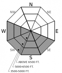
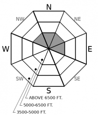
The air temperature is finally approaching average for the first time in what seems like months. With a strong mid-March sun, the wet avalanche danger is on the rise. Observations yesterday noted wet snow activity on steep southerly slopes in the Flathead Range. Warm overnight temperatures and today's potential for periods of solar input may lead to more wet avalanches. They will be most dangerous above terrain traps and in long-running gullies on sunny aspects. Wet heavy sticky snow tells you it is time to move toward shady terrain. Rollerballs and pinwheels are a precursor to larger wet slides.
-
Type ?
-
Aspect/Elevation ?

-
Likelihood ?CertainVery LikelyLikelyPossible
 Unlikely
 -
Size ?HistoricVery LargeLargeSmall

Southwesterly winds accompanied this week's snowfall and formed small, thin slabs of drifted snow on the lee (north and east) sides of ridges and saddles. Some of these slabs remain sensitive to the weight of a machine or rider. Look for these exceptions near the tops of chutes, below cornices, and on the downwind sides of passes and other terrain that funnel winds. The slabs will feel denser than snow on slopes sheltered from the wind, and cracks shooting from your board, skis or machine are a clear sign of danger.
This week is shaping up to be a transition week for our snowpack. Climbing temperatures and the strong, late-winter sun will warm the snow surface for the first time since February 2, the day the infamous Groundhog Day crust formed. Wet avalanche activity will increase daily as temperatures reach average by Tuesday and rise above normal mid-week. Wet loose slides are relatively easy to manage on sunny aspects by following the progression of the sun from east to west. We are a long ways from a corn snow surface, with the current state of snow on sunny aspects "lousy". Do yourself a favor; enjoy quality dry snow on shady aspects and avoid the Loose Wet avalanche problem. While recreating in this cold, cohesionless snow, be aware that Loose Dry sluffs can still be initiated on steep (40 degrees or greater) slopes. Stay alert and manage these sluffs while avoiding slopes directly above terrain traps.
With warming temperatures comes the threat of larger more destructive slides. Yesterday, I found a Persistent Slab avalanche in Skiumah Creek that happened earlier this week. This slide failed on the February 2 crust, was a whopping 60" deep, and may have been initiated by an icefall from increasing temperatures. Another avalanche problem which we have not given thought to lately is cornice failure. Increasing temperatures weaken cornices, which could cause them to fail. These "bombs of the backcountry" can trigger weak layers in the snowpack such as the February 2 crust. Cornices require extended periods of warming for failure to occur. So we are not expecting cornice failure today, or tomorrow, but put it on our radar for the remainder of the week.
Clouds moved into our area overnight limiting radiational cooling. They may also limit the amount of sunshine and warming today. The ridge will rebound over the region causing warm and dry conditions for the majority of the week.
This forecast applies only to backcountry areas outside established ski area boundaries. The forecast describes general avalanche conditions and local variations always occur. This forecast expires at midnight on the posted day unless otherwise noted. The information in this forecast is provided by the USDA Forest Service who is solely responsible for its content.


