| Thursday | Thursday Night | Friday | |
|---|---|---|---|
| Cloud Cover: | Partly Cloudy | Mostly Cloudy | Partly Cloudy |
| Temperatures: | 26 to 31 deg. F. | 13 to 18 deg. F. | 28 to 33 deg. F. |
| Wind Direction: | West | West | West |
| Wind Speed: | 7 to 12, gusting to 20 | 10 to 15, gusting to 25 | 10 to 15, gusting to 25 |
| Snowfall: | 0 in. | 0 in. | 0 in. |
| Snow Line: | 2000 | 1000 | 3500 |
Flathead Range and Glacier National Park
How to read the forecast
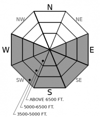
To avoid triggering loose wet avalanches today, trade steep, sunny aspects for shaded or lower-angled terrain. Watch for rollerballs and wet snow at the surface as signs that conditions are deteriorating.

2. Moderate
?
Above 6500 ft.
2. Moderate
?
5000-6500 ft.
2. Moderate
?
3500-5000 ft.
- 1. Low
- 2. Moderate
- 3. Considerable
- 4. High
- 5. Extreme
-
Type ?
-
Aspect/Elevation ?

-
Likelihood ?CertainVery LikelyLikelyPossible
 Unlikely
 -
Size ?HistoricVery LargeLargeSmall

As the snowpack warms today the risk of loose wet avalanches will increase. With 5” to 12" of new snow to thaw, slides could run further than expected. Rollerballs originating from rocky areas or vegetation are often the first signs of instability. Pay attention to loose snow becoming wet. Move to lower-angled, shady slopes early to avoid the problem.
The storm that swept across our area Tuesday/Wednesday left up to 14” of new snow in the Swan Range and 11” in the Whitefish Range. New snow totals diminished further east, with the Flattop weather station showing 5” of new snow and very little reported from John F. Stevens Canyon. Zach found 12” of new snow lower down in the Middle Fork, but storm totals actually decreased with elevation.
Avalanche activity from the new loading was confined to a few small storm slabs sliding naturally and from human triggers. Mark found lots of wind drifting above Noisy Basin where shooting cracks and cornice drops were common, but new slabs were unreactive to ski cutting. A handful of small loose wet avalanches ran in very steep and rocky areas where the surface snow warmed the most during the sunny period yesterday. Manageable sluffing, and good powder skiing, were common on sheltered and shady slopes.
Today is a transitional day, weather-wise. High pressure builds into the region and temperatures may climb above freezing. The sun should be able to affect the snow and loose wet avalanches will become the primary concern.
As the snow warms and becomes wet, move to shady aspects to avoid the hazard. Lower elevations, rocky areas, and steep, concave features like gullies will warm first and most. Look for rollerballs as the first sign that the snow is becoming unstable.
Where the recent new snow has drifted into a slab, and especially where it sits atop weak layers of surface hoar and near surface facets, triggering wind slabs may still be possible. These will be most dangerous where they are thicker than about 8”.
A ridge building off the west coast will move overhead the next few days, bringing partly cloudy skies and near-freezing temperatures to upper elevations.
This forecast applies only to backcountry areas outside established ski area boundaries. The forecast describes general avalanche conditions and local variations always occur. This forecast expires at midnight on the posted day unless otherwise noted. The information in this forecast is provided by the USDA Forest Service who is solely responsible for its content.


