| Tuesday | Tuesday Night | Wednesday | |
|---|---|---|---|
| Cloud Cover: | Cloudy | Cloudy | Mostly cloudy |
| Temperatures: | 25 to 30 deg. F. | 16 to 21 deg. F. | 25 to 30 deg. F. |
| Wind Direction: | Southwest | West | Northwest |
| Wind Speed: | 10 to 15 mph, gusting to 30 | 5 to 10 mph, gusting to 20 | 5 to 10 mph |
| Snowfall: | 3" to 6" in. | 4" to 8" in. | 0 to 2" in. |
| Snow Line: | 2500' | 2000' | 1500' |
Whitefish Range
Swan Range
Flathead Range and Glacier National Park
How to read the forecast
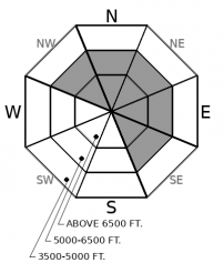
Southwest winds increased overnight forming thin slabs on leeward slopes. Today’s new snow and blustery winds will increase the size and distribution of slabs. Look for blowing snow as you gain elevation and evaluate terrain below corniced ridgelines, downwind of saddles, and in cross-loaded gullies. Generally stable and more enjoyable conditions are found in areas not affected by the wind.

2. Moderate
?
Above 6500 ft.
1. Low
?
5000-6500 ft.
1. Low
?
3500-5000 ft.
- 1. Low
- 2. Moderate
- 3. Considerable
- 4. High
- 5. Extreme
-
Type ?
-
Aspect/Elevation ?

-
Likelihood ?CertainVery LikelyLikelyPossible
 Unlikely
 -
Size ?HistoricVery LargeLargeSmall

Yesterday's breezy winds increased overnight drifting the remains of Thursday's snow onto leeward slopes. Today, new snow and southwest winds will form fresh slabs and thicken existing slabs. Expect slabs to increase in size and distribution throughout the day. Slabs may form on a variety of surfaces that will inhibit bonding. Shooting cracks are a sign to steer clear of steep slopes. Wind sheltered terrain will offer the safest and highest quality snow.
A quick shot of moisture returns to our area today with possibly a foot or more of new snow expected at upper elevations by tomorrow morning. Blustery southwest winds will drift this snow onto leeward aspects forming larger and more dangerous slabs throughout the day. Slabs will form on firm surfaces such as sun crusts and windboard along with weak layers such as facets or surface hoar (Example A, Example B, Example C). New slabs may have a difficult time adhering to these surfaces and the avalanche danger will increase as new snow accumulates. If the storm arrives sooner and/or stronger than forecast expect the avalanche danger to be more widespread. Monitor new snow totals and thickness of fresh slabs as you gain elevation. Cracking and shooting cracks are signs of instability. In areas where slabs form on facets, surface hoar and crusts expect the unexpected. Slabs may propagate further and run farther than anticipated. The snow that the FAC staff has enjoyed the most of late is in sheltered terrain where good riding conditions exist.
Snow returns to our area this morning lasting through the night. Expect breezy southwest winds, relatively mild temperatures and up to a foot of snow by tomorrow morning.
This forecast applies only to backcountry areas outside established ski area boundaries. The forecast describes general avalanche conditions and local variations always occur. This forecast expires at midnight on the posted day unless otherwise noted. The information in this forecast is provided by the USDA Forest Service who is solely responsible for its content.


