| Wednesday | Wednesday Night | Thursday | |
|---|---|---|---|
| Cloud Cover: | Overcast | Mostly Cloudy | Mostly Cloudy |
| Temperatures: | 17 to 22 deg. F. | 8 to 14 deg. F. | 23 to 28 deg. F. |
| Wind Direction: | Northeast | East | Southwest |
| Wind Speed: | 10 to 20, G30 | 5 to 15, G20 | 15 to 25, G40 |
| Snowfall: | 1 to 2" in. | 1 to 2" in. | 1 to 2" in. |
| Snow Line: | 500' | 500' | 1000' |
Whitefish Range
How to read the forecast
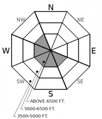
Instabilities are rare - but not impossible - to find. You are most likely to encounter the exception to an otherwise stable snowpack just below alpine ridgelines, where fresh or older drifts could still bite, especially in extreme terrain. Back off of steep objectives if you see cracks shooting from beneath your skis or machine.

1. Low
?
Above 6500 ft.
1. Low
?
5000-6500 ft.
1. Low
?
3500-5000 ft.
- 1. Low
- 2. Moderate
- 3. Considerable
- 4. High
- 5. Extreme
-
Type ?
-
Aspect/Elevation ?

-
Likelihood ?CertainVery LikelyLikelyPossible
 Unlikely
 -
Size ?HistoricVery LargeLargeSmall

In a few wind exposed areas, northeast winds last weekend formed drifts downwind of ridges, in gullies and behind trees in abnormal patterns. You are most likely to encounter lingering instabilities at high elevations near the crest of the Whitefish Range, while most areas are offering stable, wind-sheltered powder. Slabs are generally small and starting to bond, but they could still cause problems if they push you into trees or over rock bands. You can avoid this problem in wind affected terrain by choosing wind-scoured or well-supported terrain features away from lens-shaped drifts of thicker snow.
The daily string of human-triggered wind slabs continues. These have all been in the Flathead Range and Glacier Park: Tuesday above Dickey Lake, Monday on Sheep Mountain, Sunday on Mt. Brown, Sunday in Wahoo Creek. Although we have fewer field observations from the Swan Range, we have visual evidence that it got hit just as hard by the winds as the Flathead Range. In the Whitefish Range, we are finding that wind effects were less dramatic: wind slabs are smaller, more isolated, and quicker to heal. The danger in the Whitefish Range is LOW and triggering an avalanche is unlikely, not to be confused with impossible.
Yesterday in the Middle Fork, Mark found that wind slabs are still bonded poorly to underlying surfaces, which include low-density snow, near surface facets, and wind-hardened surfaces. Although warmer temperatures yesterday and today will finally help these wind slabs start to stabilize, avoiding them for another day or two is a prudent choice. Surface texture is your best weapon for avoiding wind slabs, but today's flat light will make it harder to distinguish the problematic areas in the alpine. It is a good day to enjoy the high-quality powder in wind-protected areas, where we are consistently finding stable riding conditions. Winds increased last night and may be forming a new generation of shallow wind drifts in a few wind-affected locations where there is still soft snow available for transport.
Light snowfall will spread across the region today. Look for a few inches to accumulate across the forecast area each day into the weekend. Warmer, windier southwest flow returns by tomorrow.
This forecast applies only to backcountry areas outside established ski area boundaries. The forecast describes general avalanche conditions and local variations always occur. This forecast expires at midnight on the posted day unless otherwise noted. The information in this forecast is provided by the USDA Forest Service who is solely responsible for its content.


