| Tuesday | Tuesday Night | Wednesday | |
|---|---|---|---|
| Cloud Cover: | Mostly Clear | Increasing clouds | Overcast |
| Temperatures: | 20 to 25 deg. F. | 1 to 6 deg. F. | 14 to 21 deg. F. |
| Wind Direction: | East | Northeast | Northeast |
| Wind Speed: | 0 to 10 | 5 to 15, G25 | 5 to 15, G25 |
| Snowfall: | 0" in. | 0" in. | 1 to 3" in. |
| Snow Line: | 0' | 0' | 0' |
Whitefish Range
Flathead Range and Glacier National Park
How to read the forecast
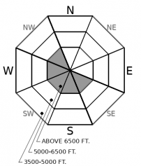
Another beautiful day to get in the mountains! Wind slabs that formed over the weekend are getting harder to trigger, but could still take you for an unpleasant ride in high consequence terrain. Take advantage of the good visibility to identify and steer around lenses of wind-thickened snow.

2. Moderate
?
Above 6500 ft.
1. Low
?
5000-6500 ft.
1. Low
?
3500-5000 ft.
- 1. Low
- 2. Moderate
- 3. Considerable
- 4. High
- 5. Extreme
-
Type ?
-
Aspect/Elevation ?

-
Likelihood ?CertainVery LikelyLikelyPossible
 Unlikely
 -
Size ?HistoricVery LargeLargeSmall

Northeast winds last weekend formed problematic drifts downwind of ridges, in gullies, and behind trees under abnormal loading patterns. Human-triggered wind slabs over the last few days were anywhere from a few inches to 18" thick (Example A, Example B, Example C). Wind slabs are larger and more widespread as you gain elevation, but they can be found at all elevations. Although slabs are becoming more stubborn with each passing day, some are dense enough to break above you. You'll find good stability and better snow quality if you stick to areas protected from the wind. If you are pushing higher into wind affected terrain, aim for wind scoured or well-supported terrain features and steer around lens-shaped drifts on steep, consequential terrain.
Tolerable temperatures, blue skies, and easy-to-manage avalanche problems are all coming together for another great day to ride powder in the mountains. There are still a few areas where you can get into trouble, but fortunately, these should be easy to identify. The northeast winds this weekend left an obvious scar on the snowy landscape where they did the most damage. Note the trees with snow blasted off their bows and sculpted snow features on the surface to warn you of the wind's unwanted treachery. Winds scoured Friday's low-density snow out of typical start zones and deposited it into slabs in an irregular pattern. Some slabs are hard, some soft, some shallow, some thick, some slow to heal over persistent weak layers, some quicker to heal. But they all have one thing in common: you can spot them if you pay attention to the thickness and texture of the snow surface. Look for smooth, dense, chalky, pillow-shaped snow on the leeward side of wind blasted terrain. Or retreat to a wind-protected basin to enjoy the high quality, stable powder right now.
We could see enough solar warming today for a few small wet loose slides in steep, rocky areas that get intense sunshine. This should be a minor issue, but it is worth keeping your eyes open for rollerballs or sluffing in southerly terrain below cliffs and steep gullies. The March sun is getting higher in the sky and temperatures are forecasted to rise 10 degrees warmer than yesterday.
Our last day of brilliant sunshine before we return to a slightly-more-active weather pattern for the rest of the week. The warming trend continues with temperatures expected to rise 10 degrees warmer than yesterday. Clouds will start to increase late this afternoon and we'll see light snowfall over the next few days as moisture overruns cold air entrenched in the region. This is the same type of "light snowfall" that has produced surprising snow totals in recent weeks. Stay tuned.
This forecast applies only to backcountry areas outside established ski area boundaries. The forecast describes general avalanche conditions and local variations always occur. This forecast expires at midnight on the posted day unless otherwise noted. The information in this forecast is provided by the USDA Forest Service who is solely responsible for its content.


