| Sunday | Sunday Night | Monday | |
|---|---|---|---|
| Cloud Cover: | Clear | Mostly clear | Clear |
| Temperatures: | 0 to 5 deg. F. | -20 to -10 deg. F. | 0 to 5 deg. F. |
| Wind Direction: | Northeast | Northeast | Northeast |
| Wind Speed: | 15 gusting to 25 | 10 gusting to 20 | 10 gusting to 15 |
| Snowfall: | 0" in. | 0" in. | 0" in. |
| Snow Line: | 0' | 0' | 0' |
Whitefish Range
Swan Range
Flathead Range and Glacier National Park
How to read the forecast
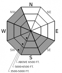
The Arctic winds are decreasing but fresh slabs should be expected on unusual slopes at all elevations with areas of a firm or textured snow surface a sign of wind effect. The safest and best riding conditions will be found in areas sheltered from the wind. Cold temperatures and dangerously cold wind chills will complicate rescue and we recommend keeping it simple today.

2. Moderate
?
Above 6500 ft.
2. Moderate
?
5000-6500 ft.
2. Moderate
?
3500-5000 ft.
- 1. Low
- 2. Moderate
- 3. Considerable
- 4. High
- 5. Extreme
-
Type ?
-
Aspect/Elevation ?

-
Likelihood ?CertainVery LikelyLikelyPossible
 Unlikely
 -
Size ?HistoricVery LargeLargeSmall

Over the past 48 hours, northeast winds have drifted up to a foot of low-density snow from Friday's storm. A natural wind slab avalanche was observed in the Middle Fork yesterday. Areas of loading are unusual and require vigilance as you travel on slopes not normally affected by wind. Fresh slabs will be soft and sensitive to your weight with shooting cracks an obvious red flag. Older slabs will be firmer, not as reactive, possibly hollow sounding and chalky in texture. Look for blowing snow as you gain elevation with scoured slopes offering a safer route. Higher quality snow and safer avalanche conditions are found in areas sheltered from the wind.
We are in the midst of yet another Arctic intrusion with extremely cold temperatures (-36 in Polebridge at 5 a.m.) and breezy northeast winds. Winds since Friday have been strong enough to transport the low-density surface snow and we expect to find slabs of varying thickness and hardness in unusual locations at all elevations. Due to the cold and wind chill, observations were limited yesterday with one party noting a fresh wind slab avalanche in the Middle Fork. My driving tour of the Middle Fork, John F. Stevens Canyon, and interior Glacier Park offered great insight into the unusual scouring and loading patterns that these northeast wind events offer.
The FAC staff is still getting a handle on the avalanche hazard related to northeast wind events. Winds from this direction are generally few and far between, except for this year, and we do not have a great historical record of what areas are affected/unaffected. Lack of observations during these events has contributed to uncertainty with our forecasts. On slopes not affected by winds, the danger will generally be LOW. There are pockets of terrain experiencing loading where the danger may be elevated. It is up to you to make slope specific assessments, more so with these unusual wind events.
We have removed the Persistent Slab problem from our list of current avalanche problems. We had been most recently concerned about the faceted 2/2 (Groundhog Day) crust responsible for a number of natural and human triggered avalanches earlier in February. We have removed this problem due to not seeing or hearing about signs of instability in over a week, this layer generally became reactive during loading events and we are currently in a benign weather pattern and the slab is starting to decay in the shallowest/most suspect areas due to the recent cold snap.
An arctic air mass has entrenched itself into our region. Cold temperatures with decreasing winds and clear skies are expected today and tomorrow.
This forecast applies only to backcountry areas outside established ski area boundaries. The forecast describes general avalanche conditions and local variations always occur. This forecast expires at midnight on the posted day unless otherwise noted. The information in this forecast is provided by the USDA Forest Service who is solely responsible for its content.


