| Thursday | Thursday Night | Friday | |
|---|---|---|---|
| Cloud Cover: | Mostly cloudy | Mostly cloudy | Mostly cloudy |
| Temperatures: | 18 to 23 deg. F. | 2 to 7 deg. F. | 8 to 13 deg. F. |
| Wind Direction: | Northeast->West | Southwest | Northeast |
| Wind Speed: | 5 to 10, gusting to 20 | 10 to 15, gusting to 25 | 15 to 20, gusting to 30 |
| Snowfall: | 2 to 5 in. | 2 to 7 in. | 2 to 5 in. |
| Snow Line: | 500 | 0 | 0 |
Whitefish Range
Swan Range
Flathead Range and Glacier National Park
How to read the forecast
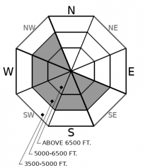
The hazard posed by wind slabs that formed earlier this weak is diminishing, though the avalanche danger will rise again late today as new snow and winds create a new generation of wind slabs. The safest, best riding is in wind-sheltered terrain, though you may have to hunt and peck for long lines of undisturbed snow. Avoid steep slopes with dense deposits of drifted snow or where blowing snow is forming soft, cohesive slabs.

2. Moderate
?
Above 6500 ft.
1. Low
?
5000-6500 ft.
1. Low
?
3500-5000 ft.
- 1. Low
- 2. Moderate
- 3. Considerable
- 4. High
- 5. Extreme
-
Type ?
-
Aspect/Elevation ?

-
Likelihood ?CertainVery LikelyLikelyPossible
 Unlikely
 -
Size ?HistoricVery LargeLargeSmall

Yesterday’s observations confirmed that Monday night’s wind-blast left slabs of drifted snow at middle and upper elevations. While evidence of the wind-damaged surface snow is widespread, slabs that could pose a danger seem confined to ridges at mid elevations but are more widespread on open slopes at upper elevations. The harder versions are likely to produce the largest slides and can be the trickiest to manage because they can break above you. Best to just avoid provoking these temperamental creatures by avoiding steep slopes where the snow feels or sounds hollow or doesn’t allow you or your snowmobile to sink in more than a few inches.
-
Type ?
-
Aspect/Elevation ?

-
Likelihood ?CertainVery LikelyLikelyPossible
 Unlikely
 -
Size ?HistoricVery LargeLargeSmall

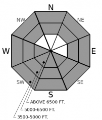
Weak layers that formed before the start of February's Siberian weather have grown dormant. The slabs above them are starting to facet in some spots. However, they're still propagating in a few tests, so steer clear of the terrain that may harbor potential trigger points: convex, unsupported slopes with variable snow depths. A near-miss occurred in the Whitefish Range last week when a lone rider crossed one of these shallow spots on a steep slope with variable snow depths. If you feel whumpfing collapses, you've found one of the isolated slopes where this structure remains a danger.
Model forecasts are showing accumulating snow and increasing winds this afternoon and tonight. By nightfall, I expect slabs of new and drifted snow to still be thin, small, and isolated. Be on the lookout for the exceptions, especially above terrain traps. Plan on increased avalanche danger for tomorrow if model forecasts verify.
The wind slab problem that is today’s primary concern is actually two problems. The first is freshly-formed slabs of drifted snow noted above. These young’uns will be thin and confined to terrain where winds can gather up the few inches of new snow and pack it into cohesive slabs, like steep slopes on the lee sides of ridges, gullies, and saddles. An older generation of slabs – mostly formed Monday night – is, like many older generations, more stubborn yet more unpredictable. Look for these cranky old timers near ridges and in open, crossloaded slopes at upper elevations.
Snow showers arrive mid-day, accompanied by a shift to west and southwesterly winds. These may be gusty at times. Snowfall and wind speeds intensify overnight. This system will favor the Swan and Whiteish Ranges.
This forecast applies only to backcountry areas outside established ski area boundaries. The forecast describes general avalanche conditions and local variations always occur. This forecast expires at midnight on the posted day unless otherwise noted. The information in this forecast is provided by the USDA Forest Service who is solely responsible for its content.


