| Wednesday | Wednesday Night | Thursday | |
|---|---|---|---|
| Cloud Cover: | Mostly cloudy | Mostly cloudy | Mostly cloudy |
| Temperatures: | 18 to 23 deg. F. | 7 to 12 deg. F. | 20 to 25 deg. F. |
| Wind Direction: | Northeast | Northeast | Northeast |
| Wind Speed: | 8 to 13, gusting to 20 | 5 to 10, gusting to 15 | 5 to 10, gusting to 15 |
| Snowfall: | 1 to 4 in. | 0-1 in. | 2 to 5 in. |
| Snow Line: | 500 | 500 | 500 |
Whitefish Range
Swan Range
Flathead Range and Glacier National Park
How to read the forecast
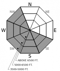
You can find trouble today, but you’ll have to look for it. The safest, best riding is in terrain sheltered from the wind. If you stray from this terrain, you might find the exceptions: steep slopes where recent winds have drifted snow into slabs sensitive to a person’s weight. Return to the better alternatives if you encounter small drifts behind trees, branches empty of snow, and dense, harder snow underfoot or under your sled.

2. Moderate
?
Above 6500 ft.
2. Moderate
?
5000-6500 ft.
1. Low
?
3500-5000 ft.
- 1. Low
- 2. Moderate
- 3. Considerable
- 4. High
- 5. Extreme
-
Type ?
-
Aspect/Elevation ?

-
Likelihood ?CertainVery LikelyLikelyPossible
 Unlikely
 -
Size ?HistoricVery LargeLargeSmall

The idiosyncratic wind patterns of the past few days have scattered slabs of drifted snow onto steep slopes near ridges and downwind of saddles and passes. A few inches of new snow today may provide the raw materials for pockets of fresh soft slabs. Both generations of wind slab will be most widespread on the southerly and westerly faces of the Swan and Whitefish Ranges, which are subjected to the strongest winds during these arctic events. You may also find them on cross-loaded southerly slopes in the Flathead Range and Glacier National Park. Since most terrain seems to be unaffected by the winds, stay heads up for the exceptions, which should give themselves away: cracking, small drifts, tree branches free of snow, and snow that's dense enough to keep your boards or sled from sinking into the snow.
-
Type ?
-
Aspect/Elevation ?

-
Likelihood ?CertainVery LikelyLikelyPossible
 Unlikely
 -
Size ?HistoricVery LargeLargeSmall

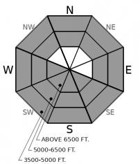
Triggering a slide on the February 2nd faceted crust remains a concern in areas harboring a shallow snowpack or variable depths. This weak layer is buried 2-5' below the surface and found on most slopes at low and mid elevations and south through west at upper elevations. It is generally found closer to the surface in the Whitefish Range, where it has resulted in recent collapsing and human-triggered avalanches (Example 1, Example 2). Utilizing terrain management is the preferred solution for dealing with this complex problem. Steering around convexities and cross-loaded slopes are recommended. Collapsing and shooting cracks are obvious signs to head for lower angle terrain.
Today’s biggest uncertainty is the distribution of wind slabs. The clearest takeaway from the past few days is that slabs of drifted snow aren’t widespread. Observations from yesterday do, however, suggest the prevailing northeasterly winds have reached into higher terrain, bumping the danger in the Flathead Range back up to Moderate. At upper elevations, the winds have built cornices above southerly slopes in the Whitefish Range and affected the snow surface on some northerly and easterly slopes in the Flathead Range and Stevens Canyon, possibly cross-loading some of these slopes as well. A few inches of snow today may camouflage this older generation of slabs and provide enough snow for a new batch of small but sensitive slabs. Resolve this uncertainty by staying heads-up for signs of drifted snow at all elevations and aspects. Small test slopes can give you a great sense of whether these pockets of drifted snow are reactive to your weight or that of your snowmobile.
A southwesterly flow will push warmer air overhead, producing light snow today and Thursday. Upper elevations will see slightly warmer temperatures today, while winds continue to blow from the northeast at most locations.
This forecast applies only to backcountry areas outside established ski area boundaries. The forecast describes general avalanche conditions and local variations always occur. This forecast expires at midnight on the posted day unless otherwise noted. The information in this forecast is provided by the USDA Forest Service who is solely responsible for its content.


