| Tuesday | Tuesday Night | Wednesday | |
|---|---|---|---|
| Cloud Cover: | Mostly cloudy | Mostly cloudy | Mostly cloudy |
| Temperatures: | 5 to 10 deg. F. | -10 to -5 deg. F. | 15 to 20 deg. F. |
| Wind Direction: | Northeast | Northeast | Northeast |
| Wind Speed: | 15 to 20, gusting to 30 | 5 to 10, gusting to 20 | 5 to 10, gusting to 20 |
| Snowfall: | 0 in. | 0 in. | 0 to 2 in. |
| Snow Line: | 0 | 0 | 0 |
Flathead Range and Glacier National Park
How to read the forecast
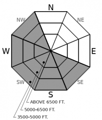
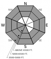
The onslaught of northeast winds and bitterly cold wind chill continues. The snowpack is generally stable in the Flathead Range and Glacier Park, but watch for isolated areas where the wind has been transporting snow. Areas sheltered from the wind will hold safer and higher quality snow. Buried weak layers remain a concern in areas with a thin snowpack. Steer around convexities in favor of planar well-supported slopes.

1. Low
?
Above 6500 ft.
1. Low
?
5000-6500 ft.
1. Low
?
3500-5000 ft.
- 1. Low
- 2. Moderate
- 3. Considerable
- 4. High
- 5. Extreme
-
Type ?
-
Aspect/Elevation ?

-
Likelihood ?CertainVery LikelyLikelyPossible
 Unlikely
 -
Size ?HistoricVery LargeLargeSmall

By this afternoon, our area will have been subjected to 72 hours of continuous north-east winds, though local terrain features can funnel winds into different directions. Winds from the northeast seem to affect more terrain in the Swan and the Whitefish Range than the Flathead Range and Glacier Park. Expect unusual loading patterns. Recent examples of unusual loading include Sunday's skier-triggered wind slab avalanche on a southerly aspect in the Whitefish Range, a party which avoided a low elevation gully receiving significant wind loading in the Swan Range, and thick supportable wind slab development in the Apgars. Look for blowing snow at all elevations, with cracking, collapsing and hollow sounding snow a sign that you are on a slab. Areas sheltered from the winds will hold safer and higher quality snow.
-
Type ?
-
Aspect/Elevation ?

-
Likelihood ?CertainVery LikelyLikelyPossible
 Unlikely
 -
Size ?HistoricVery LargeLargeSmall

Triggering a slide on the February 2nd faceted crust remains a concern in areas harboring a shallow snowpack or variable snow depths. This weak layer is buried 2-5' below the surface and found on most slopes at low and mid elevations and south through west aspects at upper elevations. It is generally found closer to the surface in the Whitefish Range, where it has resulted in recent collapsing and human-triggered avalanches (Example 1, Example 2). Utilizing terrain management is the preferred solution for dealing with this complex problem. Steering around convexities and cross-loaded slopes are recommended. Collapsing and shooting cracks are obvious signs to head for lower angle terrain.
The latest in a series of Arctic intrusions have been affecting our area with moderate to strong northeast winds since Saturday afternoon (2/23). Observations Sunday highlighted wind transport in the Whitefish Range and the Swan Range, with reports of cohesionless snow in the Flathead Range (Observation 1, Observation 2). The sole observation received Monday was Clancy's from the Swan Range, where he noted wind slab development on top of low-density snow. The Swan Range and the Whitefish Range received the lion's share of Saturday's rogue snowfall event, and these areas also seem to be the most affected by northeast winds, a combination resulting in elevated avalanche danger. The avalanche danger is LOW in Glacier Park and the Flathead Range due to less snowfall Saturday and less terrain affected by the northeast winds. If you are recreating in Glacier or the Flathead Range, there is wind slab formation occurring, but we have yet to receive a report of where. Keep a watchful eye out for unusual loading patterns in all locations of our advisory area as our uncertainty is high due to limited observations involving this wind event.
IFrame
Cold windy conditions are on tap through today and tonight. Slightly warmer temperatures with light snowfall and less windy conditions are expected tomorrow.
This forecast applies only to backcountry areas outside established ski area boundaries. The forecast describes general avalanche conditions and local variations always occur. This forecast expires at midnight on the posted day unless otherwise noted. The information in this forecast is provided by the USDA Forest Service who is solely responsible for its content.


