| Monday | Monday Night | Tuesday | |
|---|---|---|---|
| Cloud Cover: | Mostly cloudy | Mostly cloudy | Partly cloudy |
| Temperatures: | -1 to 11 deg. F. | -10 to -5 deg. F. | 2 to 12 deg. F. |
| Wind Direction: | Northeast | Northeast | Northeast |
| Wind Speed: | 15 to 20, gusting to 35 | around 25, gusting to 45 | around 15, gusting to 30 |
| Snowfall: | 0 to 3 in. | 3 to 6 in. | 0 in. |
| Snow Line: | 0 | 0 | 0 |
Flathead Range and Glacier National Park
How to read the forecast
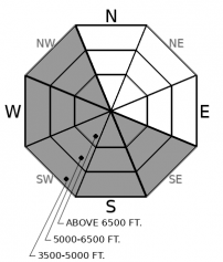
Continued northeast winds will drift snow in unique loading patterns at all elevations. Look for blowing snow with cracking and collapsing signs of instability. Areas sheltered from the wind will hold safer and higher quality snow. Triggering a Persistent Slab avalanche is a low-likelihood, high-consequence problem that is best managed through terrain selection. Avoid convexities while seeking out planar well-supported slopes with a uniform snow cover.

1. Low
?
Above 6500 ft.
1. Low
?
5000-6500 ft.
1. Low
?
3500-5000 ft.
- 1. Low
- 2. Moderate
- 3. Considerable
- 4. High
- 5. Extreme
-
Type ?
-
Aspect/Elevation ?

-
Likelihood ?CertainVery LikelyLikelyPossible
 Unlikely
 -
Size ?HistoricVery LargeLargeSmall

Atypical north-east winds overnight and through today will continue their unique loading pattern. Unlike our typical southwest winds, the northeast winds seem to "miss" large swaths of our area, such as the Middle Fork, but wreak havoc in isolated locations at all elevations. A skier triggered a wind slab avalanche yesterday on a southerly aspect in the Whitefish Range and another party avoided a low elevation gulley that was getting significant wind loading and looked downright scary in the Swan Range. Look for blowing snow at all elevations with cracking, collapsing and hollow sounding snow a sign that you are on a slab. Areas sheltered from the winds will hold safer and higher quality snow.
-
Type ?
-
Aspect/Elevation ?

-
Likelihood ?CertainVery LikelyLikelyPossible
 Unlikely
 -
Size ?HistoricVery LargeLargeSmall

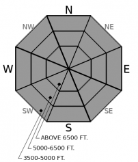
Feedback from the February 2nd faceted crust is waning but this layer buried 2-5' below the surface remains a concern. In locations with a deep snowpack collapses, triggered avalanches, and propagation in snowpit tests is becoming limited. However, areas harboring a shallower snowpack continue to exhibit propagation in snowpit tests, collapsing, and human-triggered avalanches occurring during the past 10 days. Defaulting to terrain management is the best solution for dealing with this complex problem. Avoiding convexities and areas with a variable snowpack such as a cross-loaded slope is best. Collapsing and shooting cracks are obvious signs to abort and head for lower angle terrain.
Saturday's storm favored the Whitefish Range and the Swan Range with a foot or more of low-density cold smoke with the Flathead Range and Glacier Park receiving about half this amount. Cold temperatures are limiting settlement of this snow resulting in delightful and stable cohesionless snow found in areas unaffected by the wind. Atypical northeast winds entered our area Saturday morning and will continue through Tuesday. Winds from this direction are somewhat rare and determining drifting patterns is a bit perplexing. Large swaths of the Middle Fork seem to be unaffected by these winds while other areas, such as the front side of the WMR ski area get raked over. These winds seem to affect low elevation terrain as much, or more so than the upper elevations as evidenced by yesterday's observation from the Swan Range. It appears that the Swan Range and the Whitefish Range receive the most damage from northeast winds and therefore we have kept the danger elevated in these areas. Reports from the Flathead Range yesterday and GNP Saturday were of stable snow and cohesionless billowing powder and we have dropped the danger to LOW in the Flathead Range and Glacier National Park. (Observation 1, Observation 2, Observation 3). If recreating in the Park or the Flathead Range keep a watchful eye out for signs of windblown snow in areas you may least expect it. Fresh wind slab development is occurring in these areas but we have yet to receive a report of where.
Light snowfall is expected to end tonight. However, east/northeast winds will remain gusty through Tuesday and beyond. Cold temperatures and very cold windchill remain the theme.
This forecast applies only to backcountry areas outside established ski area boundaries. The forecast describes general avalanche conditions and local variations always occur. This forecast expires at midnight on the posted day unless otherwise noted. The information in this forecast is provided by the USDA Forest Service who is solely responsible for its content.


