| Sunday | Sunday Night | Monday | |
|---|---|---|---|
| Cloud Cover: | Mostly cloudy | Mostly cloudy | Mostly cloudy |
| Temperatures: | 5 to 15 deg. F. | -12 to -2 deg. F. | 2 to 12 deg. F. |
| Wind Direction: | Northeast | Northeast | Northeast |
| Wind Speed: | 15 to 20, gusting to 30 | around 15, gusting to 25 | 10 to 15, gusting to 20 |
| Snowfall: | 0 in. | 0 in. | 0 to 2 in. |
| Snow Line: | 0 | 0 | 0 |
Whitefish Range
Swan Range
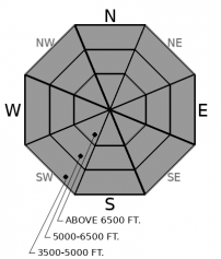
How to read the forecast
Human triggered storm slabs are possible where the surface snow has settled into a cohesive slab. Long running sluffs are possible in very steep terrain. Watch for cracking in denser snow and be wary of steep slopes above terrain traps. Very large persistent slab avalanches remain a concern. Seek out well supported, concave slopes with a deep, uniform snow cover to best avoid that larger problem.

2. Moderate
?
Above 6500 ft.
2. Moderate
?
5000-6500 ft.
2. Moderate
?
3500-5000 ft.
- 1. Low
- 2. Moderate
- 3. Considerable
- 4. High
- 5. Extreme
-
Type ?
-
Aspect/Elevation ?

-
Likelihood ?CertainVery LikelyLikelyPossible
 Unlikely
 -
Size ?HistoricVery LargeLargeSmall

The new snow will be denser today thanks to rapid settlement and northeast winds. Soft slabs can break over a foot deep where the most snow has accumulated. Watch especially for drifted snow on atypical leeward aspects. On open slopes near and above treeline, watch for shooting cracks or collapses as warning signs that you could trigger long running slides in the new snow. In very steep, sheltered terrain, sluffs can carry you into terrain traps like gullies and tree wells and bury you with deep debris piles. Monitor new snow depths. The southern Whitefish Range and the Swan Range received the highest snow amounts.
-
Type ?
-
Aspect/Elevation ?

-
Likelihood ?CertainVery LikelyLikelyPossible
 Unlikely
 -
Size ?HistoricVery LargeLargeSmall

In the past 10 days, collapses, propagating test results, and human triggered avalanches reflect our lingering concern over persistent weak layers buried between 2 and 5’ deep. The primary worry is the February 2 faceted crust. The instability is not widespread, does not give consistent feedback and can be difficult to assess with snow pit tests. Choosing simple terrain with a uniform snow cover is a better way manage the problem. Avoid convexities and areas where the snowpack is shallowest. Whumpfs and shooting cracks should point you toward lower-angled, lower consequence terrain.
Readouts from remote weather stations this morning are confirming the few observations we received from yesterday: winds were on the lighter side and wind slab formation has been limited. Zach did find drifts capable of propagating a crack yesterday near Whitefish Mountain Resort. We have a report from Mt. Brown that despite moss and twigs blowing down from the trees, snow drifts were mostly small and stubborn. Northeast winds will continue today and may be capable of further stiffening slabs on atypical, westerly, aspects.
We were lucky to get more snow than expected in the southern Whitefish Range where reported storm totals were between 12 and 16”. The Noisy Basin SNOTEL is showing a storm total of 8”. Stations near the Divide are showing 3-5” of new snow. While the initial density was low – Snow Liquid Ratios were between 17:1 and 22:1 – the new snow settled rapidly over the past 24 hours. A quick, back-of-the-envelope, calculation shows settlement rates of up to ~40%. That means snow surfaces will be a bit denser than they were yesterday morning.
To better reflect the primary avalanche problem in the forecast we’ve swapped from wind slab and loose snow problems to storm slabs. Watch for cracking in denser surface snow on steep slopes. Once surface snow gets moving it has the potential to entrain a lot more as it runs down hill. Sluffing is still possible in very steep terrain. Vegetation should be on your list of terrain traps. Getting pushed into a tree well is a serious concern where the most snow has accumulated.
We saw many persistent slab avalanches have over the past 10 days, especially in the Whitefish Range. Most recently, a skier narrowly escaped being caught in a very dangerous avalanche near Red Meadow on the 20th. These slides seem to be the result of failures around the crust buried early in the month. We saw propagating failures around the “Groundhog Day” crust Friday in snowpack tests near Werner Peak. The crust is now buried between 2.5 and 5' of snow. Triggering it may be difficult, but the resulting avalanches would be large. Reports of persistent slab activity elsewhere are limited. If you play in the mountains, please send us your observations! Mark documented some impressive persistent slab avalanches that ran during the last week’s avalanche cycle in the Flathead Range, which shows that the weak snowpack structure still exists – it may just be harder to trigger. Little feedback from deeply buried weak layers can add uncertainty to your hazard analysis. Snowpack tests can help you identify the instability, but the problem varies by aspect, elevation, and snow cover. Choosing well supported, concave slopes is a safer bet when managing this tricky problem. Look for areas with uniform snow cover; shallow spots are likely trigger points.
Northwest Montana will mainly experience east/northeast winds today and little snow accumulation. Temperatures continue to be bitterly cold. Another round of light snow is possible tomorrow.
This forecast applies only to backcountry areas outside established ski area boundaries. The forecast describes general avalanche conditions and local variations always occur. This forecast expires at midnight on the posted day unless otherwise noted. The information in this forecast is provided by the USDA Forest Service who is solely responsible for its content.


