| Friday | Friday Night | Saturday | |
|---|---|---|---|
| Cloud Cover: | Increasing clouds | Overcast | Overcast |
| Temperatures: | 15 to 20 deg. F. | 9 to 14 deg. F. | 14 to 19 deg. F. |
| Wind Direction: | Southwest | Southwest | Southwest to Northwest |
| Wind Speed: | 10 to 20, gusting to 30 | 10 to 20, gusting to 35 | 5 to 15, gusting to 30 |
| Snowfall: | 0 to 1 in. | 4 to 8 in. | 2 to 5 in. |
| Snow Line: | 0 | 0 | 0 |
Whitefish Range
How to read the forecast
Pay attention to signs of fresh wind drifting as you gain elevation today: winds have increased out of the south. Weak layers buried 2 to 4 feet deep continue to hint at lingering instabilities, particularly in the Whitefish Range, where a skier escaped a very large persistent slab on Wednesday.

2. Moderate
?
Above 6500 ft.
2. Moderate
?
5000-6500 ft.
2. Moderate
?
3500-5000 ft.
- 1. Low
- 2. Moderate
- 3. Considerable
- 4. High
- 5. Extreme
-
Type ?
-
Aspect/Elevation ?

-
Likelihood ?CertainVery LikelyLikelyPossible
 Unlikely
 -
Size ?HistoricVery LargeLargeSmall

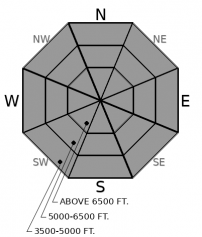
Thick persistent slabs 2 to 4 feet deep continue to hint at lingering instabilities on some slopes, particularly in the Whitefish Range. Several observations of audible collapses (Example A, Example B), clean propagating test results, and triggered slides this week highlight the continued potential to trigger a dangerously large avalanche. The most recent was a skier who narrowly avoided getting swept downhill by a D3 avalanche near Red Meadow. The weak layers are mostly facet/ crust combinations that formed early this month. These instabilities are not widespread, nor do they give frequent and clear feedback under your feet or sled. Guard yourself and your partners from this serious hazard by avoiding steep slopes where your weight affects deeply buried weak layers. These include convex rollovers, slopes with variable snow depths and thin spots, and forest openings at lower elevations where the snowpack is shallowest. Hightail it to lower-angled, less consequential terrain if you feel any whumpfing collapses or see shooting cracks.
-
Type ?
-
Aspect/Elevation ?

-
Likelihood ?CertainVery LikelyLikelyPossible
 Unlikely
 -
Size ?HistoricVery LargeLargeSmall

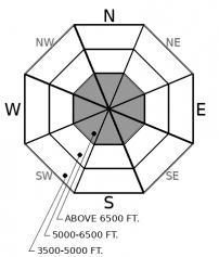
Variable northerly and now southerly winds have formed small pockets of slab near ridgelines and in wind exposed cirques and gullies. A skier yesterday intentionally triggered a 1' soft slab from a ridgeline on Mt. Brown, and another observer noted cracking in harder, wind-stiffened snow. Look for blowing snow as a sign of instability today as winds shift to the southwest. Steer around denser drifts and lenses of stiff snow in consequential terrain, especially if you notice cracking beneath your skis or machine.
Observers yesterday reported that Wednesday night's northeast wind event was relatively benign, leaving isolated pockets of wind slab, some of which were reactive and cracking. Winds switched to the south last night ahead of the next Pacific system, and mountain stations are showing wind speeds in the teens, gusting into the 20s. These aren't alarming wind speeds, but enough to continue drifting soft surface snow in a few choice locations. If your travels take you to high elevations or wind exposed mid elevations, keep an eye out for blowing snow, fresh drifts, or lingering pockets of stiffer snow left over from previous northerly winds.
Yesterday, FAC staff visited the site of a near miss in the Northern Whitefish Range (see observation). On Wednesday, a skier was caught in a 4-foot slab avalanche that broke on facets above the Groundhog Day crust. He was ascending the slope without any obvious signs of instability like shooting cracks or collapses, but the avalanche broke above him as he rounded a convex rollover. Photos from our site visit paint a scary picture of the type of avalanche that we are warning about with persistent slabs. Mark also snapped some excellent photos of natural persistent slab activity from the Middle Fork that ran last week during the avalanche cycle. Unfortunately, persistent slabs are not giving us clear feedback. Many slopes have found equilibrium now, but some slopes may still teeter and are hard to identify. These lingering instabilities appear to be more common in the Whitefish Range, which saw less of a gut punch from snow loading during the last storm. Snowpack tests are a useful tool right now for identifying instabilities, although spatial variability should be anticipated with subtle changes in aspect, slope angle, elevation, or wind effect. The most reliable tool to handle uncertainty is terrain selection. After assessing the snowpack, hedge your bets by choosing well anchored, concave slopes without variable snow depths.
Today we transition back to a more active pattern. Cloud cover will thicken through the day and winds have switched to the southwest ahead of the next Pacific system. Snowfall will begin around sunset, and we could see up to a foot by tomorrow night in favored locations (the Swan).
This forecast applies only to backcountry areas outside established ski area boundaries. The forecast describes general avalanche conditions and local variations always occur. This forecast expires at midnight on the posted day unless otherwise noted. The information in this forecast is provided by the USDA Forest Service who is solely responsible for its content.


