| Thursday | Thursday Night | Friday | |
|---|---|---|---|
| Cloud Cover: | Partly cloudy | Mostly clear | Increasing clouds |
| Temperatures: | 14 to 19 deg. F. | -1 to 4 deg. F. | 16 to 21 deg. F. |
| Wind Direction: | Northeast | Southwest | Northeast |
| Wind Speed: | 8 to 18, gusting to 25 | 5 to 15, gusting to 20 | 10 to 20, gusting to 35 |
| Snowfall: | 0 in. | 0 in. | 0 in. |
| Snow Line: | 0 | 0 | 0 to 1 |
Swan Range
Flathead Range and Glacier National Park
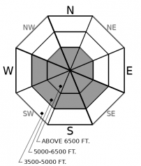
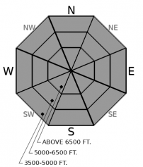
How to read the forecast
We have had more near misses and accidentally-triggered large slides in the past week than the rest of the winter combined. Many of these have involved solo travel. While the danger posed by buried weak layers and wind slabs is not widespread, it continues to catch people by surprise. To hedge your bets against drawing a joker, grab a partner, carefully assess the snowpack and choose simpler, concave terrain that is out of the wind.

2. Moderate
?
Above 6500 ft.
2. Moderate
?
5000-6500 ft.
1. Low
?
3500-5000 ft.
- 1. Low
- 2. Moderate
- 3. Considerable
- 4. High
- 5. Extreme
-
Type ?
-
Aspect/Elevation ?

-
Likelihood ?CertainVery LikelyLikelyPossible
 Unlikely
 -
Size ?HistoricVery LargeLargeSmall

Northerly winds increased overnight, and will be drifting recent snow into small but sensitive slabs in wind-exposed areas. An older generation of larger, more stubborn wind slabs formed earlier in the week. Avoid steep, consequential slopes with signs of recent wind loading. These will be most common near ridgelines, below cornices, or on sides of gullies. Pillow-shaped drifts or thicker snow, shooting cracks, and stiffer snow are all signs of wind slab formation.
-
Type ?
-
Aspect/Elevation ?

-
Likelihood ?CertainVery LikelyLikelyPossible
 Unlikely
 -
Size ?HistoricVery LargeLargeSmall

Unstable snowpack tests and signs of instability for buried weak layers 2 to 4 feet deep have waned in the past week in the Flathead and Swan Ranges. However, persistent slabs have resulted in several triggered slides and near misses in the Whitefish Range (Example A, Example B). The weak layers are mostly facet/ crust combinations that formed early this month. These instabilities are not widespread, nor do they give frequent and clear feedback under your feet and sled. Guard yourself and your partners from this serious hazard by avoiding steep slopes where your weight is most likely to affect deeply buried weak layers. These include convex rollovers, slopes with variable snow depths and thin spots, and forest openings at lower elevations where the snowpack is shallowest. Hightail it to lower-angled, less consequential terrain if you feel any whumpfing collapses or see shooting cracks, such as this skier found on Wednesday.
A string of near misses or accidental avalanches has ensued since a widespread natural avalanche cycle ended a little over a week ago. These include a skier caught in a large slide in Wahoo Creek last week. A remotely triggered slide on Half Moon, near WMR, last Friday. A number of slides triggered near Grave Creek on Sunday by snowmobiles. A two-foot slab triggered by a snowboarder yesterday near WMR. And a skier caught and carried in a 3 foot slide yesterday near Red Meadow. Most of these slides appear to be failing on facets surrounding the Groundhog's Day crust. This weak layer is fickle. Reports of stable riding and stable pit results have been more common than these close calls. The Groundhog Day crust is buried anywhere from 18" in the Northern Whitefish Range to 4' or 5' deep in parts of the Flathead and Swan Range. A pattern seems to be emerging now; we are finding more frequent reactive pits and more triggered slides occurring in the Whitefish Range. Perhaps this is because the slabs are thinner and the weak layers haven't strengthened as much the further north you go. Regardless, the continued stream of near misses involving persistent slabs should put you on guard. Our snowpack isn't speaking to us clearly right now, but in a more cryptic fashion. If the snowpack isn't talking, listen to your gut. The skier who took a scary ride yesterday said it best: "Please listen to that little voice in your head when it’s screaming at you". This is a quality lesson learned: take a minute to read the observation, and thank you for sharing.
Arctic air is spilling into the Flathead Valley, bringing a brisk wind chill to the region. Winds are currently blowing in the teens and gusting into the 20's out of the north and northeast at some mountain stations. Another round of light Pacific moisture is on tap for the weekend as flow shifts back to the southwest.
This forecast applies only to backcountry areas outside established ski area boundaries. The forecast describes general avalanche conditions and local variations always occur. This forecast expires at midnight on the posted day unless otherwise noted. The information in this forecast is provided by the USDA Forest Service who is solely responsible for its content.


