| Wednesday | Wednesday Night | Thursday | |
|---|---|---|---|
| Cloud Cover: | Overcast | Decreasing clouds | Partly cloudy |
| Temperatures: | 17 to 22 deg. F. | -2 to 3 deg. F. | 13 to 18 deg. F. |
| Wind Direction: | North | Northeast | Northeast |
| Wind Speed: | 3 to 13, gusting to 25 | 15 to 25, gusting to 40 | 12 to 22, gusting to 40 |
| Snowfall: | 1 to 2 in. | 0 in. | 0 in. |
| Snow Line: | 0 | 0 | 0 |
Whitefish Range
Swan Range
Flathead Range and Glacier National Park
How to read the forecast
You can trigger dangerous slabs of drifted or wind-stiffened snow a foot or more deep on steep mid- and upper-elevation slopes. It’s also possible to trigger slides that break much deeper, on weak layers around buried crusts. The safest slopes are those free from drifted snow, convexities, and terrain traps. The danger may rise later today and tonight as increasing wind speeds drift more snow and form larger, more widespread slabs.

3. Considerable
?
Above 6500 ft.
2. Moderate
?
5000-6500 ft.
2. Moderate
?
3500-5000 ft.
- 1. Low
- 2. Moderate
- 3. Considerable
- 4. High
- 5. Extreme
-
Type ?
-
Aspect/Elevation ?

-
Likelihood ?CertainVery LikelyLikelyPossible
 Unlikely
 -
Size ?HistoricVery LargeLargeSmall

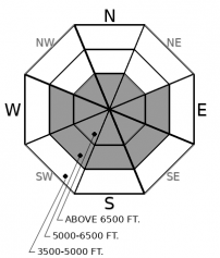
The quadrants on the aspect/ elevation rose are expanding as winds veer northerly and increase. Look for fresh slabs of drifted snow on slopes leeward to northerly winds – east through south to west. These will be larger and more dangerous at upper elevations. On some slopes, it may not take much drifted snow to stiffen underlying slabs and make them more reactive, so pay attention to subtle changes in the texture of the surface snow. Look for snow that's notably denser, chalkier, or hollow-sounding than the cohesionless snow elsewhere. Avoid riding below start zones where the wind is clearly blowing snow around.
-
Type ?
-
Aspect/Elevation ?

-
Likelihood ?CertainVery LikelyLikelyPossible
 Unlikely
 -
Size ?HistoricVery LargeLargeSmall

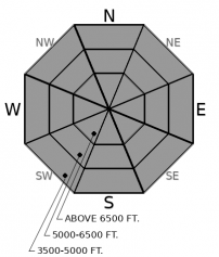
Triggered slides and snowpack tests continue to fail on weak layers buried 18 to 36 inches below the snow surface. The weak layers are mostly facet/ crust combinations that formed early this month. Guard yourself and your partners from this serious hazard by avoiding slopes where your weight is most likely to affect deeply buried weak layers. These include convex rollovers and slopes with variable snow depths where slabs may have thin spots. Stop only at points where debris from steep slopes above you won't wash over you. And hightail it to lower-angled, less consequential terrain if you feel any whumpfing collapses.
Tuesday’s observations demonstrate that slabs formed by recent storms remain sensitive to a person's weight. Or, are becoming sensitive. A party near Marion Lake reported triggering several soft slabs with slope cuts on both southerly and northerly aspects. They described conditions as requiring “heads up terrain management” and surprisingly different than two days prior. In John F. Stevens Canyon, BNSF forecasters reported Extended Column Tests propagating on three different crust/ facet combination on a mid-elevation, southerly slope. In the northern Whitefish Range, Mark and Guy found snowpack tests produced propagation on southerly and northerly slopes at mid elevations, with slabs failing on the Groundhog Day crust/ facets or on deeply buried surface hoar.
So how are conditions reactive several days after the last storm? Several possible reasons, perhaps working together. Cold temperatures have limited sintering at the storm snow interface. On slopes exposed to cross-loading or top-loading by the wind, a few inches of drifted snow is stiffening the soft, near-surface snow enough that it’s acting like a slab. On sheltered slopes, the low-density snow of the past two weeks is settling and consolidating into slabs. In any case, the avalanche system is complete: slabs over existing weak layers can collapse, propagate, and release as avalanches.
The bottom line? Adjusting your travel practices to the changing conditions will be key to riding safely today.
Expect snow showers and increasing northerly winds today. Another blast of arctic air is poised to sweep across the region tonight, bringing stronger winds and more cold temperatures.
This forecast applies only to backcountry areas outside established ski area boundaries. The forecast describes general avalanche conditions and local variations always occur. This forecast expires at midnight on the posted day unless otherwise noted. The information in this forecast is provided by the USDA Forest Service who is solely responsible for its content.


