| Tuesday | Tuesday Night | Wednesday | |
|---|---|---|---|
| Cloud Cover: | Mostly cloudy | Mostly Cloudy | Overcast |
| Temperatures: | 12 to 17 deg. F. | 5 to 10 deg. F. | 18 to 23 deg. F. |
| Wind Direction: | Southwest | Southwest | North |
| Wind Speed: | 8 to 13, gusting to 20 | 10 to 15, gusting to 25 | 7 to 12, gusting to 20 |
| Snowfall: | 0-3 in. | 2-6 in. | 0-1 in. |
| Snow Line: | 0 | 0 | 500 |
Whitefish Range
Swan Range
Flathead Range and Glacier National Park
How to read the forecast
Today you can trigger fresh slabs of drifted snow that break a foot or so deep at upper elevations. At all elevations, the most serious hazard is triggering avalanches that break on old snow buried two or more feet below the snow surface. Your chances of triggering one of these beasts increase as slope angles increase. You can leave a wider buffer against surprises by sticking to slopes less than about 35 degrees.

2. Moderate
?
Above 6500 ft.
2. Moderate
?
5000-6500 ft.
1. Low
?
3500-5000 ft.
- 1. Low
- 2. Moderate
- 3. Considerable
- 4. High
- 5. Extreme
-
Type ?
-
Aspect/Elevation ?

-
Likelihood ?CertainVery LikelyLikelyPossible
 Unlikely
 -
Size ?HistoricVery LargeLargeSmall

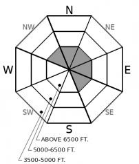
Yep, compared to yesterday, the colors on this morning's aspect/ elevation rose are reversed. That's because of a shift from northerly to southwesterly winds. The northerly winds don't seem to have left behind many cohesive slabs. Today's southwesterly winds may drift some snow into fresh slabs on easterly slopes at upper elevations. These slabs should be easy to identify just by feel - snow that's notably denser, chalkier, or hollow-sounding than the cohesionless snow elsewhere. They'll be thickest and largest downwind of saddles and passes, and on the lee sides of ridges. On steep slopes, steer around these pests, and avoid riding below start zones where the wind is clearly blowing snow around.
-
Type ?
-
Aspect/Elevation ?

-
Likelihood ?CertainVery LikelyLikelyPossible
 Unlikely
 -
Size ?HistoricVery LargeLargeSmall

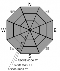
This hazard is isolated but serious. Last week's natural avalanche cycle included a few large and very large avalanches that broke on old snow 2.5 to 4 feet or more below the snow surface. And a snowmobiler triggered a slide with a deep crown in the northern Whitefish Range this weekend that looks to have released on old snow. Protect yourself and your partners from this nasty hazard by avoiding slopes where your weight is most likely to affect deeply buried weak layers. These include convex rollovers and slopes with variable snow depths where slabs are likely to have thin spots. Stop in spots where debris from steep slopes above you won't wash over you. And hightail it to lower-angled, less consequential terrain if you feel any whumpfing collapses.
Since Saturday, when the most recent storm ended, people have braved what now feels like cool – not cold – temperatures to ride throughout the forecast region. We’ve received reports of one natural avalanche and one triggered avalanche. Riders have observed few, if any, collapses or shooting cracks, and limited propagation or sudden failures in snowpit tests. Tests near or adjacent to crowns are also not producing propagation or sudden failures. The winds that accompanied the arctic air look to have been confined to the valleys; people are reporting some wind-affected snow surfaces but few slabs.
That’s a lot of “only,” “few,” “one,” “not,” and “confined.” The conclusion? February’s two weeks of snow and cold have left us avalanche problems that look to be isolated and hard to trigger. What to do with that conclusion? Guard against the exceptions while edging out into steeper, more consequential terrain.
Now the caveats: we’ve had few reports from alpine terrain – open bowls and chutes near ridgelines and above about 7,000 feet - because cold weather has kept people closer to warm cars and buildings. So recently-formed slabs could be touchier in that terrain. Likewise, nearly all the reported avalanches have been large enough to bury or injure a person, with some slides much larger. And the propagation produced in snowpack tests has occurred on deeply buried weak layers. Specifically, layers more than 2.5 feet below the surface. So any triggered slides will be large and dangerous.
You can shield yourself from the exceptions and their ugly consequences by picking lines that aren’t above terrain traps, riding one at a time, and stopping in spots that aren’t exposed to slides from above. That can take some attention and creativity in more consequential terrain.
A low tracking our way from the Pacific will bring snow showers today and more continuous snowfall tonight. Total accumulations will be light except in the Swan Range, which could pick up 6-8 inches by tomorrow morning. Wind speeds will tick up and skies will be mostly cloudy. A weak arctic airmass is sitting on the back porch, and may into the Flathead Valley late Wednesday.
This forecast applies only to backcountry areas outside established ski area boundaries. The forecast describes general avalanche conditions and local variations always occur. This forecast expires at midnight on the posted day unless otherwise noted. The information in this forecast is provided by the USDA Forest Service who is solely responsible for its content.


