| Monday | Monday Night | Tuesday | |
|---|---|---|---|
| Cloud Cover: | Partly Cloudy | Partly Cloudy | Mostly cloudy |
| Temperatures: | 6 to 16 deg. F. | -5 to 0 deg. F. | 12 to 17 deg. F. |
| Wind Direction: | South | Southwest | Southwest |
| Wind Speed: | 5 to 10 | 5 to 10, gusting to 15 | 10 to 15, gusting to 20 |
| Snowfall: | 0 in. | 0 in. | 0 in. |
| Snow Line: | 0 | 0 | 0 |
Whitefish Range
Swan Range
Flathead Range and Glacier National Park
How to read the forecast
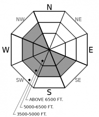
The stormy weather has ended, and our snowpack is adjusting to the last loading event. Recently-formed slabs may still be reactive to the weight of a rider and will be thickest below ridgelines and more widespread in the northern Whitefish Range and the Swan Range. Don't let today's bluebird conditions lull you into complacency as natural and triggered avalanches have been reported daily this past week. Look for cohesive surface snow while utilizing terrain management to minimize your hazard.

2. Moderate
?
Above 6500 ft.
2. Moderate
?
5000-6500 ft.
1. Low
?
3500-5000 ft.
- 1. Low
- 2. Moderate
- 3. Considerable
- 4. High
- 5. Extreme
-
Type ?
-
Aspect/Elevation ?

-
Likelihood ?CertainVery LikelyLikelyPossible
 Unlikely
 -
Size ?HistoricVery LargeLargeSmall

Winds associated with the Arctic intrusion decreased overnight, shutting down wind transport in most locations. Recently-formed slabs are gaining strength, but triggering a slide in wind-drifted snow is possible. Expect loading in unusual locations from north-east winds, with slabs being thickest on the leeward sides of ridgelines and in cross-loaded gullies. Slabs may resemble smooth pillows of snow found downwind of trees or rock outcrops. Hollow sounding snow is a sign that you are on a slab overlying less dense snow. Ascending scoured slopes and descending areas sheltered from the wind will offer the safest options.
-
Type ?
-
Aspect/Elevation ?

-
Likelihood ?CertainVery LikelyLikelyPossible
 Unlikely
 -
Size ?HistoricVery LargeLargeSmall

Our most recent loading event ended Saturday, allowing slabs 36+ hours of strengthening. Natural activity has ended, but the combination of cold temperatures and slabs forming on low-density snow is inhibiting the strengthening process. Slabs will be most widespread in the Swan Range and the northern Whitefish Range, where 1-2' of snow fell Thursday night into Saturday. Storm slabs are a surface problem identifiable by cracking or collapsing and thicken as you gain elevation. Steer around areas where you find denser cohesive snow in favor of cohesionless surfaces.
-
Type ?
-
Aspect/Elevation ?

-
Likelihood ?CertainVery LikelyLikelyPossible
 Unlikely
 -
Size ?HistoricVery LargeLargeSmall

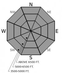
Recent loading allowed riders to trigger slides on the Groundhog Day crust Friday and Saturday. As our snowpack adjusts to last week's stormy weather, triggering a slide on weak layers buried 2-5' deep is becoming a low-likelihood, high-consequence problem, with resulting slides large and destructive. This is a difficult problem to assess; terrain management is the safest and easiest way to reduce your exposure. When in doubt, avoid convexities, large unsupported slopes, and steep slopes above terrain traps in favor of well supported lower angle terrain.
After the storm...following a week of deep snowfall and an Arctic blast, today will be a chilly but welcome respite. Observations from the weekend were limited and we don’t know how reactive recently formed slabs remain. Easing into larger more consequential terrain is advised while keeping your bluebird powder fever in check. Two of our three avalanche problems involve surface snow with hand pits, test slopes, and snow pit stability tests offering immediate feedback. The Persistent Slab problem is a difficult problem to assess with utilizing the terrain the preferred method of choice. Utilize well supported planar slopes rather than convexities while avoiding traveling on steep slopes directly above terrain traps.
The Thursday night through Saturday storm deposited 1-2’ of snow across our region with the northern Whitefish Range and the Swan Range favored. A widespread natural avalanche cycle occurred in the Swan Range Saturday morning but we have not received any observations from the northern Whitefish Range. Observations Monday confirmed natural avalanche activity in the Flathead Range and skier triggered slides in the southern Whitefish Range. Clearing skies will allow for a great day recreating in the mountains and viewing recent avalanche activity. If you are out today please send us observations and photos of recent avalanche activity.
Dry, cold air remains camped over the region, allowing partly sunny skies and light winds today and strong radiational cooling tonight. Clouds and winds increase tomorrow in advance of a weak storm Wednesday. Winds today will be southerly except in the Whitefish Range, where you can expect northerly winds.
This forecast applies only to backcountry areas outside established ski area boundaries. The forecast describes general avalanche conditions and local variations always occur. This forecast expires at midnight on the posted day unless otherwise noted. The information in this forecast is provided by the USDA Forest Service who is solely responsible for its content.


