| Sunday | Sunday Night | Monday | |
|---|---|---|---|
| Cloud Cover: | Mostly cloudy | Mostly cloudy | Partly cloudy |
| Temperatures: | 4 to 14 deg. F. | -20 to -5 deg. F. | 6 to 16 deg. F. |
| Wind Direction: | Northeast | Northeast | Northeast |
| Wind Speed: | 15 to 20, gusting to 36 | around 15, gusting to 30 | around 5, gusting to 20 |
| Snowfall: | 0 to 1 in. | 0 in. | 0 in. |
| Snow Line: | 0 | 0 | 0 |
Whitefish Range
Swan Range
Flathead Range and Glacier National Park
How to read the forecast
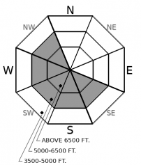
Today's northeast winds will drift low-density surface snow onto atypical aspects thickening slabs below ridgelines and in cross-loaded gullies. Recent storm snow may still produce avalanches. Natural and triggered avalanches in the surface snow and on buried weak layers occurred in our region yesterday. Watch for blowing snow and shooting cracks. Cold temperatures and dangerously cold wind chills will complicate a rescue.

3. Considerable
?
Above 6500 ft.
3. Considerable
?
5000-6500 ft.
2. Moderate
?
3500-5000 ft.
- 1. Low
- 2. Moderate
- 3. Considerable
- 4. High
- 5. Extreme
-
Type ?
-
Aspect/Elevation ?

-
Likelihood ?CertainVery LikelyLikelyPossible
 Unlikely
 -
Size ?HistoricVery LargeLargeSmall

Blustery north through east winds entered our area yesterday drifting copious low-density surface snow onto atypical aspects. Slabs will thicken through the day and be thickest below ridgelines and in cross-loaded features. Look for blowing snow and shooting cracks to direct you away from wind-loaded terrain. Scoured slopes on the windward sides of ridgelines and areas sheltered from the wind will offer the safest options.
-
Type ?
-
Aspect/Elevation ?

-
Likelihood ?CertainVery LikelyLikelyPossible
 Unlikely
 -
Size ?HistoricVery LargeLargeSmall

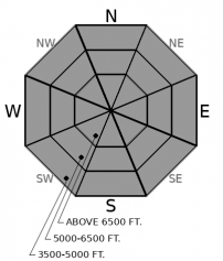
1-2 feet of snow has fallen across our region since Thursday evening initiating a widespread storm slab avalanche cycle in Noisy Basin yesterday. A cold air mass entered our area yesterday and will slow the strengthening of slabs. Slabs are widespread in the Swan Range, and portions of the Whitefish Range and the Flathead Range favored by recent snowfall. They can be identified by cracking or collapsing and thicken as you gain elevation. Steer around areas where you find denser cohesive snow in favor of cohesionless surfaces.
-
Type ?
-
Aspect/Elevation ?

-
Likelihood ?CertainVery LikelyLikelyPossible
 Unlikely
 -
Size ?HistoricVery LargeLargeSmall

Triggered slides on the Groundhog Day crust occurred yesterday in Noisy Basin and from an area just outside the WMR ski area Friday. Propagation was observed in surface hoar on the 1/17 crust in snowpit tests yesterday in the Apgars. Loading from today's winds, or a rider could reactivate these weak layers that are buried 2-5' below the surface. The safest and easiest way to deal with this problem is with terrain management. Avoid convexities and steep slopes above terrain traps in favor of well supported lower angle terrain.
A strong Arctic intrusion entered our area yesterday afternoon/evening bringing blustery northeast winds and cold temperatures. This week 2-4 feet of new snow fell which is available for transport onto atypical aspects. Wind slab development is expected to occur throughout the day onto low-density snow adding to its instability. Storm slabs from earlier in the week have healed but avalanching in the new snow since Thursday night is rated as Possible. Buried weak layers produced natural and triggered avalanches this week and remain a concern during today's loading event.
This week our region experienced a series of Pacific storms which resulted in substantial low-density snowfall and below normal temperatures. Avalanche activity was widespread with natural and human triggered avalanches failing in the storm snow and several larger avalanches stepping down 2-4 feet deep into buried weak layers. We have a secondhand report of a rider caught and carried by a large avalanche in the Middle Fork that likely failed on a weak layer that developed on Groundhog Day. Blase investigated Friday's skier triggered slide on the Groundhog Day crust just outside of the WMR ski area boundary. This slide was remotely triggered and is proof that these buried weak layers remain a concern. This weeks snow has further buried weak layers which, if fail, will result in a larger more destructive avalanche. The Persistent Slab problem deserves respect and avoidance through terrain management is the best solution.
A moisture starved modified arctic cold front has progressed well into Montana overnight with localized snow accumulations in Swan and Flathead Ranges. However the gusty east winds have also materialized in full force throughout these areas, leading to widespread blowing and drifting of snow along with limited visibility that will continue well into today. Expect even lower temperatures and very cold windchill today and tonight.
This forecast applies only to backcountry areas outside established ski area boundaries. The forecast describes general avalanche conditions and local variations always occur. This forecast expires at midnight on the posted day unless otherwise noted. The information in this forecast is provided by the USDA Forest Service who is solely responsible for its content.


