| Saturday | Saturday Night | Sunday | |
|---|---|---|---|
| Cloud Cover: | Overcast | Overcast | Overcast |
| Temperatures: | 17 to 23 deg. F. | -5 to 0 deg. F. | 5 to 10 deg. F. |
| Wind Direction: | West | Northeast | Northeast |
| Wind Speed: | 5 to 10, gusting to 20 | 10 to 20, gusting to 30 | 10 to 20, gusting to 30 |
| Snowfall: | 2 to 4 in. | 1 to 2 in. | 0 in. |
| Snow Line: | 1000 | 0 | 0 |
Whitefish Range
Flathead Range and Glacier National Park
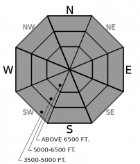
How to read the forecast
Light snow and wind continues to add weight to the snowpack. Storm slabs and loose snow avalanches are possible in steep terrain. Watch for loose sluffs and denser slabs up to 6” or more thick in steep terrain. Tricky weak layers buried 2-5 feet deep are still possible to trigger. Whumpfing and shooting cracks are red flags directing you to lower angled slopes.

2. Moderate
?
Above 6500 ft.
2. Moderate
?
5000-6500 ft.
2. Moderate
?
3500-5000 ft.
- 1. Low
- 2. Moderate
- 3. Considerable
- 4. High
- 5. Extreme
-
Type ?
-
Aspect/Elevation ?

-
Likelihood ?CertainVery LikelyLikelyPossible
 Unlikely
 -
Size ?HistoricVery LargeLargeSmall

0.5” of snow water equivalent has loaded the snowpack since yesterday. The new load sits atop a variety of old surfaces. Crusts, low density powder, and surface hoar may take a while to bond with the new snow. Watch for loose sluffs and storm slabs cracking on slopes steeper than about 35 degrees. Slabs will be more likely where wind and warmer temperatures have thickened the surface snow.
-
Type ?
-
Aspect/Elevation ?

-
Likelihood ?CertainVery LikelyLikelyPossible
 Unlikely
 -
Size ?HistoricVery LargeLargeSmall

Triggering buried weak layers of facets, crusts, and surface hoar remains possible. We have several reports of avalanches and collapses failing on the Groundhog Day crust from the recent storm. Collapses on that layer continued through Thursday in the Middle Fork and on Mt. Brown where it was found between 2 and 4 feet deep. A deeply buried layer of surface hoar from mid-January remains alive and well in the northern Whitefish Range. New avalanches failing on these layers are hard to predict. Whumpfing and deep shooting cracks are direct signs of instability underneath of you. Play it safe by choosing low-angled slopes away from convexities and terrain traps.
With continued loading from new snow and about 0.5” of new water weight, storm slabs and loose avalanches remain possible throughout the forecast area. In the Swan range, where 1.5” of snow water equivalent fell since yesterday morning, storm slabs continue to be likely.
The most recent major storm system to hit our area began Tuesday and left a widespread avalanche cycle in its wake. We have well-documented reports of natural and human triggered avalanches failing in the storm snow and several larger avalanches stepping down 2-4 feet deep into buried weak layers. We have a secondhand report of a rider caught and carried by a large avalanche in the Middle Fork that likely failed on a weak layer that developed on Groundhog Day.
The storm snow settled out quickly. The only recent instability we have seen was an isolated incident of whumpfing on Mt. Brown on Valentine’s Day and some very small wind drifts that developed yesterday in John F. Stevens Canyon. Observers in the northern Whitefish Range on Thursday found reactive surface hoar that was buried in mid-January 4’ deep. Several snowpack tests in southern Glacier Park still show the potential for propagation near the Groundhog crust. These buried weak layers worry us because identifying them and managing them can be tricky. The best management strategy is to avoid steep terrain features where the snowpack is already stressed. Convex slopes or the margins of slopes where the slab thins out are more likely trigger points. Whumpfs are red flags that these layers are present and weak beneath you.
Wrap around moisture will bring low-density snow to our area through today with cool temperatures and westerly winds. Tonight an arctic cold front will glide across the Continental Divide bringing light snowfall, reduced visibility due to gusty northeast winds and a return to bitterly cold temperatures.
This forecast applies only to backcountry areas outside established ski area boundaries. The forecast describes general avalanche conditions and local variations always occur. This forecast expires at midnight on the posted day unless otherwise noted. The information in this forecast is provided by the USDA Forest Service who is solely responsible for its content.


