| Wednesday | Wednesday Night | Thursday | |
|---|---|---|---|
| Cloud Cover: | Overcast | Decreasing clouds | Partly cloudy |
| Temperatures: | 20 to 25 deg. F. | 2 to 7 deg. F. | 20 to 25 deg. F. |
| Wind Direction: | Southwest to Northwest | North | East |
| Wind Speed: | 5 to 15, Gusting to 25 | 5 to 10 mph, gusting to 20 | 5 to 15 mph, gusting to 25 |
| Snowfall: | 6 to 9 in. | 0 to 1 in. | 0 in. |
| Snow Line: | 2000 | 0 | 0 |
Whitefish Range
How to read the forecast
Today's equation is simple: A lot of new snow + wind = human triggered avalanches. Observers yesterday reported widespread avalanche activity in the new snow and some slides breaking into older layers. The storm is shifting south of the Whitefish Range but left around a foot or more of new snow. Today is a great day to ride powder inbounds or on low angle terrain. Careful routefinding and conservative decision making are essential today.

3. Considerable
?
Above 6500 ft.
3. Considerable
?
5000-6500 ft.
3. Considerable
?
3500-5000 ft.
- 1. Low
- 2. Moderate
- 3. Considerable
- 4. High
- 5. Extreme
-
Type ?
-
Aspect/Elevation ?

-
Likelihood ?CertainVery LikelyLikelyPossible
 Unlikely
 -
Size ?HistoricVery LargeLargeSmall

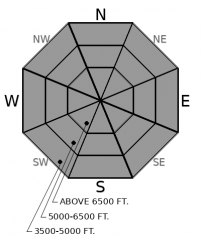
Southwest winds and around a foot of top-heavy snow has created widespread storm slab instabilities. Observers reported extensive storm slab avalanche activity breaking in the new snow yesterday. Slabs thickened overnight. Carefully assess the bonding of storm snow before traveling into steeper terrain.
-
Type ?
-
Aspect/Elevation ?

-
Likelihood ?CertainVery LikelyLikelyPossible
 Unlikely
 -
Size ?HistoricVery LargeLargeSmall

The past ten days of snow and wind have formed thick slabs over faceted layers that formed in early February. Observers yesterday noted collapses, cracking, and avalanches breaking into old layers several feet thick. Continued loading overnight will make this problem more widespread and larger. Storm snow avalanches are likely to step down and produce wider, deeper, and more destructive persistent slab avalanches. These slides can surprise you by propagating unusually wide distances and can be triggered from flat terrain below a steep slope. Defaulting to lower angle terrain is the easiest way to avoid this problem.
An avalanche cycle kicked off yesterday and likely peaked overnight. The storm is shifting south, and the bullseye for widespread natural avalanche activity and HIGH danger today will be pointed at areas that continue to receive heavy snowfall today. Regardless of natural activity, large avalanches will be easy to trigger in steep terrain and our travel advice today is to keep it simple and stay on low angle slopes today.
The Flathead Range and Whitefish Ranges were favored in the past 24 hours, with almost 2" of SWE (That's over 2 feet) at Flattop, and 1.2" at Stahl. Reports this morning from Essex are that last night's snow is top heavy and slabby. The Whitefish Range is shifting out of the storm track today, so we are lowering the danger to CONSIDERABLE there. The storm is now pointed at the Swan and Flattop Range, where we could see continued heavy snowfall rates this morning starting to taper this afternoon. Rapid loading, top-heavy snowfall is creating widespread storm instabilities and stressing the February 2nd interface, which consists of a faceted crust at low and mid elevations, and facets at upper elevations. We saw plenty of clear evidence yesterday of dangerous avalanche conditions. Today, the avalanches will be larger.
.
The moisture plume that brought heavy snowfall yesterday and last night is shifting south. Snowfall will taper off in the north to south through the day, with heavy snowfall rates still in store for the Flathead and Swan Range through late morning, at least. Winds are trending down. Dry weather arrives tonight.
This forecast applies only to backcountry areas outside established ski area boundaries. The forecast describes general avalanche conditions and local variations always occur. This forecast expires at midnight on the posted day unless otherwise noted. The information in this forecast is provided by the USDA Forest Service who is solely responsible for its content.


