| Tuesday | Tuesday Night | Wednesday | |
|---|---|---|---|
| Cloud Cover: | Mostly cloudy | Mostly cloudy | Mostly cloudy |
| Temperatures: | 22 to 27 deg. F. | 12 to 17 deg. F. | 20 to 25 deg. F. |
| Wind Direction: | Southwest | South | South |
| Wind Speed: | 5 to 10 mph, gusting to 20 | 5 to 10 mph, gusting to 20 | 10 to 15 mph, gusting to 30 |
| Snowfall: | 6 to 10 in. | 6 to 10 in. | 4 to 6 in. |
| Snow Line: | 2000 | 2000 | 2000 |
Whitefish Range
Swan Range
Flathead Range and Glacier National Park
How to read the forecast
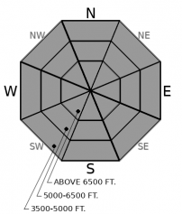
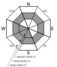
The avalanche danger is expected to rise from CONSIDERABLE today to HIGH overnight. An AVALANCHE WARNING is in effect from 5 pm today until midnight Wednesday. 1 to 2' of snow and wind will form thickening slabs on weak surface snow and buried weak layers. Surface slides have the ability to travel long distances and trigger a deeper more destructive avalanche. Monitor snow totals and look for signs of instability such as blowing snow, shooting cracks, collapsing and natural avalanches.

3. Considerable
?
Above 6500 ft.
3. Considerable
?
5000-6500 ft.
2. Moderate
?
3500-5000 ft.
- 1. Low
- 2. Moderate
- 3. Considerable
- 4. High
- 5. Extreme
-
Type ?
-
Aspect/Elevation ?

-
Likelihood ?CertainVery LikelyLikelyPossible
 Unlikely
 -
Size ?HistoricVery LargeLargeSmall

1 to 2 feet of snow in the next 24 hours will form thickening slabs on recent low-density snow. A shallow storm slab cycle occurred during yesterday's low-density snowfall, hinting at instabilities to come. With today's warmer, denser snowfall, expect storm slab instabilities to develop as new snow totals increase. Slabs will be thickest on the leeward sides of ridgelines and in cross-loaded gullies from southwest winds. If you notice cracking and collapsing it is best to steer clear of convexities and steep open slopes in favor of lower angle terrain. Expect loose dry sluffing to occur in steep terrain with sluffs having the ability to entrain a lot of snow and travel long distances.
-
Type ?
-
Aspect/Elevation ?

-
Likelihood ?CertainVery LikelyLikelyPossible
 Unlikely
 -
Size ?HistoricVery LargeLargeSmall

The past ten days of snow and wind have buried the faceted 2/2 crust 2 to 4 feet below the surface. Limited avalanche activity has been observed on this layer due to the lack of a cohesive slab but today's snow and warming temperatures may activate this persistent slab structure. Over the weekend, wind loading and new snow produced collapses, shooting cracks and an avalanche on these buried weak layers. Today's snow and wind may overload this layer or a surface slide may step down to this layer producing a large dangerous avalanche. The 2/2 crust is found on all aspects at mid-elevations and may extend into upper elevations on sunny aspects. Slides will be largest in areas favored by recent snowfall and wind loading. Make conservative decisions near steep terrain if you find a thick, cohesive slab over these buried weak layers, see shooting cracks, or feel the snowpack collapse.
A warm potent Pacific weather system entered our area overnight and will last through Wednesday evening. Over 1" of water and up to 2' of snow is expected by midnight tonight with upwards of an additional 0.5" of water on Wednesday. We anticipate the avalanche danger rising throughout the day and reaching HIGH overnight. We have issued an AVALANCHE WARNING from 5 pm today to midnight Wednesday to account for this strong storm forming slabs on weak surface snow and buried weak layers.
The new snow will be denser than the recent Arctic fluff that fell Sunday and Monday. This will form an inverted snow surface and we are anticipating natural and human triggered storm slabs to occur as the storm develops. As new snow totals increase, buried weak layers may fail resulting in large destructive slides. Small surface slides will also have the ability to affect these buried weak layers.
In the Flathead Range and southern Glacier Park, there is still a layer of weak snow at the bottom of the snowpack. During large loading events, this weak layer has failed resulting in large destructive avalanches. We do not feel that today's storm is enough to list Deep Persistent Slabs as an avalanche problem for today, but with continued snow and wind overnight, the likelihood of a very destructive avalanche failing from high, alpine terrain is increasing.
.
A warm potent Pacific storm entered our area last night and will last through Wednesday. Warmer temperatures, breezy southwest winds and copious snowfall is expected.
This forecast applies only to backcountry areas outside established ski area boundaries. The forecast describes general avalanche conditions and local variations always occur. This forecast expires at midnight on the posted day unless otherwise noted. The information in this forecast is provided by the USDA Forest Service who is solely responsible for its content.


