| Monday | Monday Night | Tuesday | |
|---|---|---|---|
| Cloud Cover: | Mostly cloudy | Mostly cloudy | Mostly cloudy |
| Temperatures: | 10 to 15 deg. F. | 0 to 5 deg. F. | 20 to 25 deg. F. |
| Wind Direction: | Southwest | South | South |
| Wind Speed: | 5 to 10 mph, gusting to 20 | 5 to 10 mph, gusting to 20 | 10 to 15 mph, gusting to 30 |
| Snowfall: | 1 to 2 in. | 2 to 4 in. | 6 to 8 in. |
| Snow Line: | 0 | 0 | 2000 |
Flathead Range and Glacier National Park
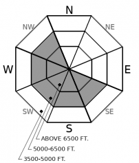
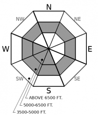
How to read the forecast
Moderating temperatures, minimal new snow, and decreasing winds are allowing our snowpack to slowly gain strength. Observations over the weekend included shooting cracks, collapses, and avalanches breaking in surface wind slabs and into buried weak layers 1 to 4 feet deep. Higher quality snow and safer conditions are found in areas sheltered from the wind.

2. Moderate
?
Above 6500 ft.
1. Low
?
5000-6500 ft.
1. Low
?
3500-5000 ft.
- 1. Low
- 2. Moderate
- 3. Considerable
- 4. High
- 5. Extreme
-
Type ?
-
Aspect/Elevation ?

-
Likelihood ?CertainVery LikelyLikelyPossible
 Unlikely
 -
Size ?HistoricVery LargeLargeSmall

Strong northeast winds redistributed Friday’s low-density snow into slabs at mid and upper elevations. Weekend observations noted unique wind drifting, shooting cracks, collapses and avalanches with fresh slabs up to a 1' thick. Look for signs of recent wind transport including textured snow, lens-shaped pillows, and hollow sounding snow found on atypical sides of ridgelines and gullies. For a safer, more enjoyable experience in steep terrain look for snow sheltered from the effects of wind.
-
Type ?
-
Aspect/Elevation ?

-
Likelihood ?CertainVery LikelyLikelyPossible
 Unlikely
 -
Size ?HistoricVery LargeLargeSmall

Observations from the weekend confirm buried persistent weak layers became reactive from recent wind loading and new snow. Collapses, shooting cracks and an avalanche in the Flathead Range failed 2 to 4 feet deep on either the 2/2 faceted Groundhog's Day crust or the 1/17 surface hoar layer in wind loaded terrain. The 2/2 crust is found on all aspects at mid-elevations and may extend into upper elevations on sunny aspects. Use caution in steep terrain if you find a thick, cohesive slab over these buried weak layers. A safer option with higher quality snow is in areas sheltered from the wind.
Yesterday's cold but benign weather was a welcome change from the Friday night/Saturday Arctic intrusion which delivered strong north and east winds to our region. Yesterday's observations noted a quiet snowpack in the southern Whitefish Range where shooting cracks and widespread wind slab development were reported Saturday. In Canyon Creek, we found wind affected snow at all elevations and on all aspects but instabilities were confined to cracking in the surface wind slab. A Persistent Slab snow structure exists with the Groundhog's Day (2/2/19) crust buried about 2 feet below the surface at mid and upper elevations. Saturday, Zach was in Noisy Basin where his group triggered dozens of shooting cracks and numerous whumpfs on low angle terrain, with failures occurring both in recent wind slabs and down on the Groundhog's Day crust. We received no observations from the Swan Range yesterday but assume that conditions are improving with the quiet weather.
The Swan Range and the southern Whitefish Range received 12-20" of snow Friday with the Flathead Range, northern Whitefish Range, and Glacier Park picking up only a few inches of snow. Avalanche problems in areas with little new snow were confined to wind drifted snow with a small wind slab avalanche cycle occurring Friday from southwest winds in Rescue Creek along with a Persistent Slab avalanche several feet deep failing on a leeward aspect.
The Arctic air mass began its retreat to the east side of the Continental Divide yesterday as southwest winds entered our area slightly moderating temperatures. Temperatures will continue to warm with increasing snow tonight through tomorrow. We expect the avalanche danger to rise tomorrow with relatively warm dense snow falling on top of low-density surface snow creating upside down (inverted) surface conditions. Increasing southwest winds will form thicker slabs on leeward aspects as the day progresses.
Winds have switched back to a more typical southwest flow ushering in moderating temperatures and light snowfall. Snowfall picks up tonight into tomorrow with increasing temperatures and wind speeds.
This forecast applies only to backcountry areas outside established ski area boundaries. The forecast describes general avalanche conditions and local variations always occur. This forecast expires at midnight on the posted day unless otherwise noted. The information in this forecast is provided by the USDA Forest Service who is solely responsible for its content.


