| Sunday | Sunday Night | Monday | |
|---|---|---|---|
| Cloud Cover: | Increasing clouds | Mostly cloudy | Partly cloudy |
| Temperatures: | 6 to 11 deg. F. | 2 to -3 deg. F. | 9 to 14 deg. F. |
| Wind Direction: | Northeast | Southwest | Southwest |
| Wind Speed: | 7 to 17, gusting to 25 mph | 2 to 12 mph | 2 to 12 mph |
| Snowfall: | 1 to 2 in. | 1 to 3 in. | 0 to 1 in. |
| Snow Line: | 0 | 0 | 0 |
Flathead Range and Glacier National Park
How to read the forecast
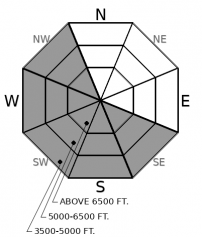
A few inches of new snow and northeast winds have formed sensitive wind slabs in some leeward terrain features. Observers yesterday triggered slabs up to 8" thick. Be cautious of lens and pillow shaped drifts below ridges and in gullies.

2. Moderate
?
Above 6500 ft.
2. Moderate
?
5000-6500 ft.
1. Low
?
3500-5000 ft.
- 1. Low
- 2. Moderate
- 3. Considerable
- 4. High
- 5. Extreme
-
Type ?
-
Aspect/Elevation ?

-
Likelihood ?CertainVery LikelyLikelyPossible
 Unlikely
 -
Size ?HistoricVery LargeLargeSmall

A few inches of low-density snow has drifted into sensitive slabs by northeast winds. Observers found cracking, collapsing, and triggered small wind slabs below leeward ridgelines yesterday. Thicker feeling snow is your warning sign: avoid lens shaped pillows of harder snow downwind of ridges, rollovers, and in gullies. Seek out wind sheltered, soft snow in steep terrain and steer around wind drifts in consequential terrain.
-
Type ?
-
Aspect/Elevation ?

-
Likelihood ?CertainVery LikelyLikelyPossible
 Unlikely
 -
Size ?HistoricVery LargeLargeSmall

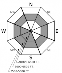
Recent wind loading has added weight to buried weak layers one to three feet deep. These layers include the faceted Groundhog's Day crust, found extensively on all aspects to 6,000' and higher on sunny aspects, or the 1/17 surface hoar layer, at mid-elevation, shadier aspects. The ingredients for these problems to become reactive do not appear to be in place yet for the Flathead Range, which saw smaller loading from the most recent storm. Be wary of exceptions in steep, windloaded terrain, such as this avalanche last week, which we suspect failed on a buried persistent weak layer.
Following Friday's bounty of low-density snowfall, Friday night's wind damage appears to be more extensive than we expected, and we've bumped the danger rating back up for the Swan and Whitefish Ranges. We still have limited observations, thanks to a nasty windchill that makes for challenging backcountry travel. It appears that the most dangerous terrain today will be the Southern Whitefish Range and Swan Ranges. These areas saw 12 to 20" of low-density snow on Friday, which was subsequently ravished by extensive Northeast winds across terrain at all elevations on Friday night and Saturday. On the Switchback Trail up to Noisy Basin, my group triggered dozens of shooting cracks and numerous whumpfs on low angle terrain, with failures occurring both in recent wind slabs and down on the Ground Hog's day crust. We got similar observations from the Southern Whitefish Range. We have been waiting for a cohesive slab to form over the Groundhog's Day crust (see this observation from a few days ago), and Friday night's wind event appears to have done the trick. Both avalanche problems, the fresh wind slabs and deeper weak layers, will be most problematic on leeward terrain favored by northeast winds. They may be a bit less reactive than yesterday, but cold temperatures slow the healing process in the snowpack.
The Northern Whitefish Range and Flathead Range scraped out only a few inches of snow from Friday's storm. An observation from the Essex Area yesterday suggests wind transport wasn't as extensive, either, but they found easily triggered, shallow wind slabs below leeward ridgelines. In the Flathead Range and Northern Whitefish Range expect to find smaller avalanche problems that are less widespread and mostly confined to the recent wind drifted snow. You may also encounter sluffing in steep, wind sheltered terrain, the type that could be powerful enough to stuff you into a gulley or tree. In these areas, buried weak layers are mostly still waiting for a more dramatic load like what was just delivered to the Swan and Southern Whitefish Range.
Keep in mind that this week's arctic weather pattern will make it difficult to do normally easy things like stopping to check out conditions or communicate observations. And waiting for a rescue would be downright brutal. Make simple and clear travel plans with your partners before you leave the house, bring extra layers, and build an extra layer of conservative decision making into your routes.
Cold, arctic air is entrenched across the Flathead, with mountain temps a not-so-balmy -10F to -20F and downtrending winds. Light moisture will overrun the cold airmass through the week producing light snowfall accumulations.
This forecast applies only to backcountry areas outside established ski area boundaries. The forecast describes general avalanche conditions and local variations always occur. This forecast expires at midnight on the posted day unless otherwise noted. The information in this forecast is provided by the USDA Forest Service who is solely responsible for its content.


