| Sunday | Sunday Night | Monday | |
|---|---|---|---|
| Cloud Cover: | Overcast | Overcast | Overcast |
| Temperatures: | -12 to 12 deg. F. | -20 to -5 deg. F. | -5 to 5 deg. F. |
| Wind Direction: | East | East | Northeast |
| Wind Speed: | 15 to 20 mph, gusting to 45 | 10 to 20 mph, gusting to 35 | 10 to 15 mph, gusting to 30 |
| Snowfall: | 2 to 5 in. | 0 to 2 in. | 1 to 3 in. |
| Snow Line: | 0 ft | 0 ft | 0 ft |
Whitefish Range
Swan Range
How to read the forecast
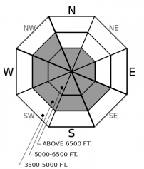
An Arctic intrusion entered our area overnight and strong easterly winds and light snow will continue through the day. Dangerous avalanche conditions are developing on atypical leeward aspects with fresh slab formation below ridgelines and in cross-loaded gullies. Wind-deposited snow, or small wind slab avalanches, may cause buried weak layers to become reactive. Look for signs of instability such as shooting cracks and whumpfing. Areas sheltered from the wind offer a safer alternative.

3. Considerable
?
Above 6500 ft.
2. Moderate
?
5000-6500 ft.
1. Low
?
3500-5000 ft.
- 1. Low
- 2. Moderate
- 3. Considerable
- 4. High
- 5. Extreme
-
Type ?
-
Aspect/Elevation ?

-
Likelihood ?CertainVery LikelyLikelyPossible
 Unlikely
 -
Size ?HistoricVery LargeLargeSmall

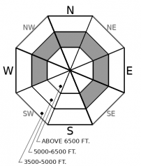
Over the past few days, southwest winds formed several generations of wind slabs on typical (easterly) leeward aspects. Strong easterly winds and snow overnight and through the day are developing fresh slabs on atypical (westerly) aspects. Slabs will be found beneath ridgelines and saddles and on cross-loaded features such as gullies. Due to the strong wind speeds, slabs may form lower in the starting zone than normal. Slabs will form on a variety of surfaces including crusts, loose snow, surface hoar and facets which may inhibit bonding. Look for blowing snow as you gain elevation and signs of instability such as cracking, hollow sounding snow and collapsing. Safer conditions and higher quality snow will be found in areas sheltered from the wind.
-
Type ?
-
Aspect/Elevation ?

-
Likelihood ?CertainVery LikelyLikelyPossible
 Unlikely
 -
Size ?HistoricVery LargeLargeSmall

Observations yesterday confirm that weak layers buried 1-2' below the surface remain reactive in stability tests. Today's windblown snow will stress these layers and a small wind slab avalanche has the potential to initiate a Persistent Slab avalanche. Areas of greatest concern are steep, mid-elevation slopes open to the sky where surface hoar and facets likely developed. Signs of instability include shooting cracks and collapsing. Keep your guard up while traveling above terrain traps.
A drastic change in the weather occurred overnight as an Arctic air mass invaded our region. Yesterday's warm and soggy weather was replaced by bitterly cold temperatures, strong northeasterly winds, and light snow. In our area, the epicenter for these intrusions is the Highway 2 corridor between Essex and Marias Pass. As of 2 a.m., the Snowslip weather station in John F Stevens Canyon is reporting -14º F with average wind speeds in the 30s and gusts into the 40s. Little precipitation has fallen overnight but snow is forecast to increase throughout the day. Strong winds are developing dangerous avalanche conditions on upper elevation atypical aspects. Observations yesterday in Noisy Basin noted plenty of snow on upper elevation easterly aspects available for transport. Snow up to 6000' may be too dense for substantial transport due to yesterday's warming. Unusual weather produces unusual avalanche activity and today might be one of those days... Slabs on atypical aspects, wind-deposited snow further down the slope than anticipated, new low-density snow not adhering to surface crusts. A good day to enjoy riding lower consequential terrain out of the wind.
New snow and wind will stress buried weak layers in our snowpack at mid-elevations. Surface hoar and facets are buried 1-2' deep and were reactive in snowpit stability tests and in hand shear tests yesterday in Noisy Basin and Canyon Creek. The only good thing from yesterday's warming was that the snowpack surface is now locked up at the lower end of the middle elevation band which will inhibit Persistent Slab avalanche activity. However, a wind slab avalanche, or a rider hitting the "sweet" spot, has the potential to trigger a Persistent Slab avalanche throughout the middle elevation band.
We have returned Deep Persistent Slabs to the problem list today for Glacier Park and the Flathead Range. We dropped it for one day yesterday to accommodate the more immediate danger of loose wet avalanches. Weak facets at the bottom of the snowpack are still present in the upper elevations with new loading or a wind slab avalanche having the potential to initiate one of these beasts.
EDUCATION: Sign up for one of our upcoming classes: Companion Rescue Clinic 02/09/2019 and Introduction to Avalanches (non-motorized) 02/28/2019 to 03/02/2019.
An arctic air mass continues to spill across the Divide and push south and west today. Expect much colder temperatures, strong easterly winds, and dangerously cold wind chill.
This forecast applies only to backcountry areas outside established ski area boundaries. The forecast describes general avalanche conditions and local variations always occur. This forecast expires at midnight on the posted day unless otherwise noted. The information in this forecast is provided by the USDA Forest Service who is solely responsible for its content.


