| Saturday | Saturday Night | Sunday | |
|---|---|---|---|
| Cloud Cover: | Overcast | Overcast | Overcast |
| Temperatures: | 32 to 37 deg. F. | -15 to -5 deg. F. | -10 to 5 deg. F. |
| Wind Direction: | Southwest | Southeast | East-northeast |
| Wind Speed: | 10 to 20 mph, gusting to 45 | 5 to 15 mph, gusting to 35 | 10 to 20 mph, gusting to 35 |
| Snowfall: | 2 to 5 in. | 2 to 4 in. | 3 to 4 in. |
| Snow Line: | 5000 ft | 2000 ft | 0 ft |
Whitefish Range
Swan Range
Flathead Range and Glacier National Park
How to read the forecast
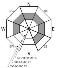
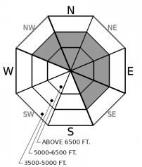
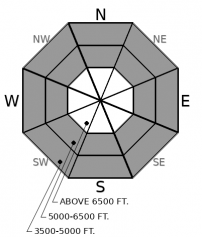
Complex avalanche conditions are developing today. Dense snow and strong southwest winds are forming slabs on the lee sides of ridges, gullies, and saddles. The new load is adding weight to fragile layers of surface hoar and facets buried between 1-2 feet deep at middle elevations. Prolonged warming is increasing the chances for loose wet avalanches. Watch for blowing snow, shooting cracks, and wet surface snow as red flags. The danger may rise as more snow accumulates tomorrow.

3. Considerable
?
Above 6500 ft.
3. Considerable
?
5000-6500 ft.
2. Moderate
?
3500-5000 ft.
- 1. Low
- 2. Moderate
- 3. Considerable
- 4. High
- 5. Extreme
-
Type ?
-
Aspect/Elevation ?

-
Likelihood ?CertainVery LikelyLikelyPossible
 Unlikely
 -
Size ?HistoricVery LargeLargeSmall

Dense new snow is adding to the slabs above weak layers of surface hoar and facets buried in mid-January. These slabs are between 1-2 feet thick and have been most reactive on steep, mid-elevation slopes open to the sky. We have the most reports of persistent slab avalanches from the Swan and Whitefish ranges. Shooting cracks and whumpfing noises are red flags that you can trigger these slabs. Be suspicious of small, steep slopes above terrain traps.
-
Type ?
-
Aspect/Elevation ?

-
Likelihood ?CertainVery LikelyLikelyPossible
 Unlikely
 -
Size ?HistoricVery LargeLargeSmall

Southwest winds have been drifting snow onto leeward slopes for the past few days, and this loading will continue today. Dense new snow will form hard slabs that may break in surprising ways. Some older slabs may still be reactive. To avoid getting caught off guard, watch for blowing snow near ridgelines and across gully walls. Shooting cracks from under your machine or your feet are a direct sign of instability. Step back from steep leeward slopes with new cornices growing overhead.
-
Type ?
-
Aspect/Elevation ?

-
Likelihood ?CertainVery LikelyLikelyPossible
 Unlikely
 -
Size ?HistoricVery LargeLargeSmall

Prolonged warm air coupled with wet snow or rain at lower elevations is increasing the risk of loose wet avalanches. Some remote weather stations have not reported below freezing temperatures since early Thursday night. Friday, wet snow was widespread below about 6000’ feet. Moving wet debris can be very hard to escape. Avoid steep slopes where you or your sled are sinking into wet snow or releasing rollerballs from your track.
Rise and shine campers! And don’t forget your booties because it’s wet and nasty out there today! A warm and wet pacific air mass has entered Montana. The majority of the moisture has tracked south of our area, but the gusty winds that ushered in this system will only increase. Prolonged warming, snow and rain, gusty winds and buried weak layers make for a complicated situation today. We’ve condensed down to one forecast and highlighted the most likely problems to try to simplify your decision making.
In general, the most worrisome elevation band remains between 4500 and 6500 feet. Buried weak layers are still visible up to 2 feet below the surface on northwest to northeast to southeast slopes. New wind slabs may develop near treeline, and loose wet avalanches may entrain large amounts of snow that could step-down into the mid-January surface hoar. Cautious route finding and conservative decision making will be your best bet for navigating the complexities on your way to upper elevations.
On leeward slopes where drifting continues, the avalanche problem may be more predictable, but also more sensitive as new wind slabs build. They will continue to grow as dense snow gets redistributed throughout the day. Blowing snow will indicate the most dangerous slopes.
We have removed deep persistent slabs from the problem list today to accommodate the more immediate danger of loose wet avalanches. But weak facets at the bottom of the snowpack are still present in the upper elevations of Glaceir Park and and the Flathead Range. Be wary of steep convexities with shallow or variable coverage in that area. Shooting cracks and collapsing are signs that you may have already wandered into harm’s way. Be disciplined with your route selection today. Avoid terrain traps and slopes steeper than about 30 degrees as a starting point. Prepping for your Superbowl party tomorrow from the comfort of your kitchen is probably your safest bet if the forecast looks too overwhelming.
EDUCATION: Sign up for one of our upcoming classes: Companion Rescue Clinic 02/09/2019 and Introduction to Avalanches (non-motorized) 02/28/2019 to 03/02/2019.
Freezing rain and a few inches of dense snow are expected today with gusty southwest winds. Temperatures hover around freezing before an arctic air mass spills across the Divide tonight, when temperatures plummet.
This forecast applies only to backcountry areas outside established ski area boundaries. The forecast describes general avalanche conditions and local variations always occur. This forecast expires at midnight on the posted day unless otherwise noted. The information in this forecast is provided by the USDA Forest Service who is solely responsible for its content.


