| Friday | Friday Night | Saturday | |
|---|---|---|---|
| Cloud Cover: | Mostly cloudy | Mostly cloudy | Mostly cloudy |
| Temperatures: | 30 to 35 deg. F. | 25 to 30 deg. F. | 30 to 35 deg. F. |
| Wind Direction: | Southwest | Southwest | Southwest |
| Wind Speed: | 15 to 20 mph, gusting to 35 | 20 to 25 mph, gusting to 45 | 20 to 25 mph, gusting to 45 |
| Snowfall: | 0 in. | 3 to 6 in. | 2 to 7 in. |
| Snow Line: | 4000 ft | 5000 ft | 4500 ft |
Whitefish Range
Swan Range
How to read the forecast
It’s not quite Groundhog Day, but today seems a lot like the last few days. Primary danger? Mid-elevations, where you can still trigger slabs that break one to two feet deep on buried surface hoar. At upper elevations, gusty winds have been forming firm but small slabs sensitive to the weight of a snowmobile or person. The avalanche danger will rise with new snow and gusty winds overnight and this weekend.

1. Low
?
Above 6500 ft.
2. Moderate
?
5000-6500 ft.
1. Low
?
3500-5000 ft.
- 1. Low
- 2. Moderate
- 3. Considerable
- 4. High
- 5. Extreme
-
Type ?
-
Aspect/Elevation ?

-
Likelihood ?CertainVery LikelyLikelyPossible
 Unlikely
 -
Size ?HistoricVery LargeLargeSmall

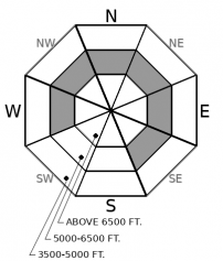
The most widespread concern in the snowpack? Still the surface hoar and facets that were buried after the mid-January dry spell. These often show as a distinct gray stripe visible 10 to 24 inches below the snow surface. Triggering slabs on these layers is becoming more difficult. The spots most likely to harbor this danger are steep, mid-elevation slopes open to the sky. Keep your guard up as you pass through terrain like this on your way down from, or up to, ridges. Be suspicious of typically innoucuous slopes like road cuts and gully walls, where small slides can have big consequences. Shooting cracks and whumpfing collapses are red flag signs that this hazard is alive and well.
-
Type ?
-
Aspect/Elevation ?

-
Likelihood ?CertainVery LikelyLikelyPossible
 Unlikely
 -
Size ?HistoricVery LargeLargeSmall

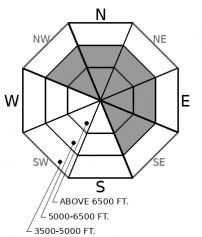
Since Sunday, upper elevations have seen gusty southwesterly winds that have formed thin but hard slabs that can be surprisingly dangerous. These are scattered through mid- and upper elevation terrain. Where they exist, they can be sensitive to a person's weight; a rider was caught and carried on Wednesday in a newly-formed slab. Beware of fresh, firm drifts on steep slopes, especially those where the winds are actively blowing snow around. With more gusty winds today, this problem will become more widely distributed.
Bill Murray’s character in the classic Groundhog Day movie eventually freed himself from an endless cycle of repetition. He lightheartedly practiced to be his best every day, despite the apparent pointlessness of it. Be Bill Murray. The incoming storm will change conditions, but in the meantime, diligently look for the mid-elevation terrain likely to harbor the surface hoar buried Jan. 17 and take the small steps that can minimize your chances of being surprised by this lingering danger.
As a general guide, it remains a concern where it’s visible as a distinct grey stripe in the snowpack. That’s mostly slopes between 4500 and 6500 feet that face northwest through north to southeast, as seen in this graphic. As you climb up or ride down through this terrain, keep an eye on your partners and avoid short, steep slopes above terrain traps, like gullies.
Upper elevation terrain has seen some gusty winds the past few days, with stronger winds forecast for today. These winds have formed some thin but firm slabs that can easily be triggered by a person or snowmobile. The problem is more widespread in the Flathead Range and Marias Pass area, where the winds had four to ten inches of fresh snow to play with. It’s an isolated problem elsewhere.
We continue to list Deep Persistent Slab (DPS) as an avalanche problem for the Flathead Range and Glacier National Park. It has only been a week since the last reported deep slabs in this area (Skiumah Lake, Essex Creek). That’s not long enough to shelve this concern, because the cold snowpack and rocky terrain of this zone generally harbors deep slab problems longer than the Whitefish or the Swan Ranges. Keep avoiding steep, convex slopes where the snow cover is likely to be variable due to bouts of wind loading and scouring.
Weather-wise, it’s Superbowl weekend. The Pacific Warmers face off against the Arctic Blast, in what looks to be a fairly even match. The Warmers are expected to score early, but it’s not clear they can hold off the Blast late in the game. Betting is all over the map, with some forecasts calling for a high-scoring game (a foot or more of new snow by Sunday afternoon and rising avalanche danger). Others see a grinding, low scoring battle that only brings frigid, sub-zero temperatures. Might be best watched from inside. Get your snacks and pull up the lazy boy.
EDUCATION: It's a great time to hone your avalanche knowledge or start learning the basics. Ladies Avalanche Awareness Talk - Kalispell Brewing Company -01/30/2019 6:30 PM.
Sign up for one of our upcoming classes: Companion Rescue Clinic 02/09/2019 and Introduction to Avalanches (non-motorized) 02/28/2019 to 03/02/2019.
Warmer, windier, wetter. The general trends are pretty clear. The exact numbers tougher to pin down. Expect near-freezing temperatures up high today, with increasing winds and strong, maybe extreme gusts this afternoon. Snow tonight shuts off tomorrow morning, though another round is forecast for late Saturday.
This forecast applies only to backcountry areas outside established ski area boundaries. The forecast describes general avalanche conditions and local variations always occur. This forecast expires at midnight on the posted day unless otherwise noted. The information in this forecast is provided by the USDA Forest Service who is solely responsible for its content.


