| Tuesday | Tuesday Night | Wednesday | |
|---|---|---|---|
| Cloud Cover: | Mostly clear | Partly cloudy | Mostly cloudy |
| Temperatures: | 23 to 28 deg. F. | 6 to 11 deg. F. | 22 to 27 deg. F. |
| Wind Direction: | Southwest | Southwest | Southwest |
| Wind Speed: | 5 to 10 mph, gusting to 20 | 5 to 10 mph, gusting to 15 | 5 to 10 mph, gusting to 25 |
| Snowfall: | 0 in. | 0 in. | 0 in. |
| Snow Line: | 500 ft | 500 ft | 1000 ft |
Whitefish Range
Swan Range
How to read the forecast
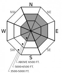
Benign weather is allowing our snowpack to gain strength. Recent winds formed thin slabs on all aspects; these may be sensitive to the weight of a rider. Slabs will be thickest between Essex and Marias Pass, an area favored by snowfall Sunday night. Weak layers buried 1-2' below the surface remain a concern at low and mid-elevations. Look for signs of wind scouring and deposition as you gain elevation. Areas sheltered from the wind will offer softer snow.

2. Moderate
?
Above 6500 ft.
2. Moderate
?
5000-6500 ft.
1. Low
?
3500-5000 ft.
- 1. Low
- 2. Moderate
- 3. Considerable
- 4. High
- 5. Extreme
-
Type ?
-
Aspect/Elevation ?

-
Likelihood ?CertainVery LikelyLikelyPossible
 Unlikely
 -
Size ?HistoricVery LargeLargeSmall

An impressive wind event Sunday brought strong southwest winds with extreme gusts. Fresh slabs on easterly aspects were easy to intentionally trigger at mid-elevations yesterday in southern Glacier Park. On Sunday we received a report of wind loading and fresh slabs that were easy to trigger in the Flathead Range. Light east winds developed Sunday night forming thin soft slabs on westerly aspects. Slabs will be thickest between Essex and Marias Pass, an area favored by snowfall Sunday night. Areas of scoured snow will have a sandblasted or scoured look with opposing terrain looking smooth and rounded and lens or pillow shaped.
-
Type ?
-
Aspect/Elevation ?

-
Likelihood ?CertainVery LikelyLikelyPossible
 Unlikely
 -
Size ?HistoricVery LargeLargeSmall

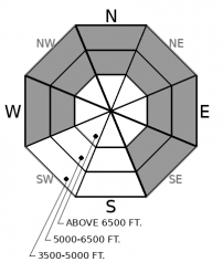
A layer of surface hoar or facets buried 1-3' deep remains a concern between 4500' and 6500'. While avalanche activity involving this layer has diminished, observations - audible failures and propagation in tests - confirm this layer has not healed. Buried surface hoar and facets are most reactive within clearings on aspects where the January sun was not able to destroy these layers. Generally, these are all aspects except due south and southwest. The danger is magnified on small slopes above terrain traps which allow even a shallow slide to pile up deep debris.
Yesterday’s roller coaster of wild weather necessitated a bump to CONSIDERABLE avalanche danger in the Flathead Range and Glacier Park. Up to 1” of water, a foot of snow, extreme southwest wind gusts and moderate east winds raised the danger in a very small corner of this forecast region between John F Stevens Canyon and Marias Pass. Clancy visited this area yesterday and found fresh easily triggered wind slabs, audible failure confirming our Persistent Slab problem along with stability tests confirming the propagation potential of our Deep Persistent Slab. Following 24 hours of benign weather, we have dropped the avalanche danger back to MODERATE.
We continue to list Deep Persistent Slab (DPS) as an avalanche problem for the Flathead Range and Glacier National Park. It has only been 1 week since the last reported deep slab in this area (Skiumah Lake, Essex Creek). This terrain generally harbors deep slab problems longer than the Whitefish or Swan Range due to the relatively thin cold snowpack and steep rocky alpine terrain. A Deep Persistent Slab snow structure can still be found but a substantial loading event is required to trigger a slide. This loading may arrive in the form of heavy snow, rain, cornice fall or an extended period of warm air temperatures which allows melt water to percolate through the snowpack.
Persistent Slab snow structure. Observations from the weekend included impressive shooting cracks, collapsing and cracking on buried weak layers in the Apgars, Canyon Creek, and the Flathead Range. FAC staff easily triggered persistent slabs 1-2’ deep on Friday in the northern Whitefish Range.
Sadly, 3 people died in avalanches in the western US on Friday. That brings the month's tally to 10, with 3 more in BC. Many of these accidents involved large or very large Persistent Slab Avalanches. These accidents are grim reminders that it's critical to keep your guard up and rely on safe travel practices to reduce your exposure. Our hearts go out to the families and friends of those involved.
EDUCATION: It's a great time to hone your avalanche knowledge or start learning the basics. Ladies Avalanche Awareness Talk - Kalispell Brewing Company -01/30/2019 6:30 PM.
Sign up for one of our upcoming classes: Motorized Introduction to Avalanches 01/31/2019 to 02/02/2019, Companion Rescue Clinic 02/09/2019 and Introduction to Avalanches (non-motorized) 02/28/2019 to 03/02/2019.
A ridge of high pressure is building over the region and will cause mostly clear skies and cool nights for the next few days.
This forecast applies only to backcountry areas outside established ski area boundaries. The forecast describes general avalanche conditions and local variations always occur. This forecast expires at midnight on the posted day unless otherwise noted. The information in this forecast is provided by the USDA Forest Service who is solely responsible for its content.


