| Thursday | Thursday Night | Friday | |
|---|---|---|---|
| Cloud Cover: | Partly Cloudy | Partly Cloudy | Mostly Cloudy |
| Temperatures: | 22 to 27 deg. F. | 17 to 22 deg. F. | 27 to 32 deg. F. |
| Wind Direction: | West | West | West |
| Wind Speed: | 10 to 15 gusting to 25 | 10 to 15 gusting to 25 | 10 to 15 gusting to 25 |
| Snowfall: | 0 to 1 in. | 0 to 2 in. | 2 to 6 in. |
| Snow Line: | 1000 | 1500 | 2000 |
Swan Range
How to read the forecast
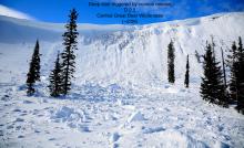
The storm has ended, but conditions are ripe for human-triggered avalanches. These can break in the new snow, or 2 feet deep on weak layers buried in mid-January. Conservative decision making is essential today, especially at mid-elevations, where a buried surface hoar layer has been producing avalanches all week.

3. Considerable
?
Above 6500 ft.
3. Considerable
?
5000-6500 ft.
2. Moderate
?
3500-5000 ft.
- 1. Low
- 2. Moderate
- 3. Considerable
- 4. High
- 5. Extreme
-
Type ?
-
Aspect/Elevation ?
-
Likelihood ?CertainVery LikelyLikelyPossible
 Unlikely
 -
Size ?HistoricVery LargeLargeSmall

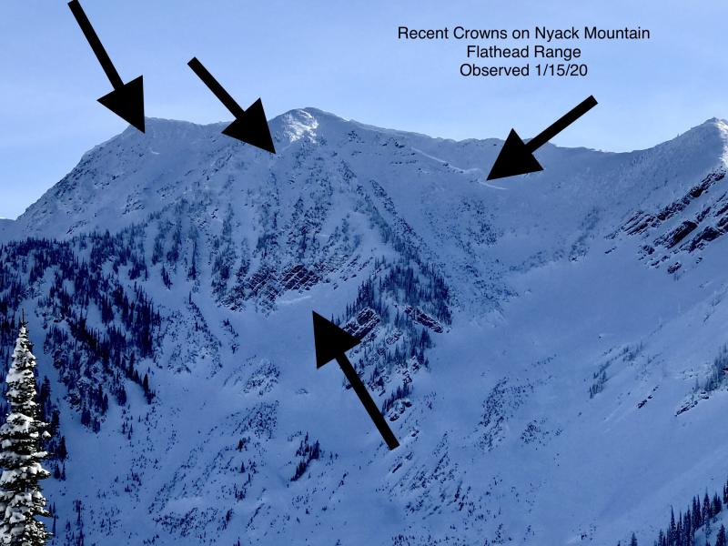
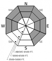
Yesterday's storm has increased the potential size of avalanches breaking on weak layers buried in mid-January. Buried surface hoar has consistently produced avalanches, shooting cracks, and collapses every day this week. These slides will break 18" to 24" deep and can propagate long distances into terrain adjacent to or above you. The most reactive slabs will be at unusually low elevations - 4500 to 6000 feet, and are more prevalent on colder aspects and open slopes with a clear view of the sky. Slides on small slopes can produce alarming amounts of debris into creek beds and gullies, the type of terrain that could get you in trouble as you descend in elevation. The easiest and most reliable way to avoid this problem is staying on terrain that is consistently less than 30 degrees in steepness where weak layers are present. Crusts and near surface facets at this same interface also exist at upper elevations, but have produced fewer instabilities in the past week.
-
Type ?
-
Aspect/Elevation ?

-
Likelihood ?CertainVery LikelyLikelyPossible
 Unlikely
 -
Size ?HistoricVery LargeLargeSmall

Numerous storm slabs and loose dry avalanches ran yesterday around our forecast area. In the Swan Range, these instabilities will be about a foot deep. Slides breaking in the new snow remain a concern, especially in areas that saw more snowfall, recent wind loading, or above terrain traps such as trees or gullies. Ease into steeper terrain by testing small slopes and looking for shooting cracks.
-
Type ?
-
Aspect/Elevation ?
-
Likelihood ?CertainVery LikelyLikelyPossible
 Unlikely
 -
Size ?HistoricVery LargeLargeSmall

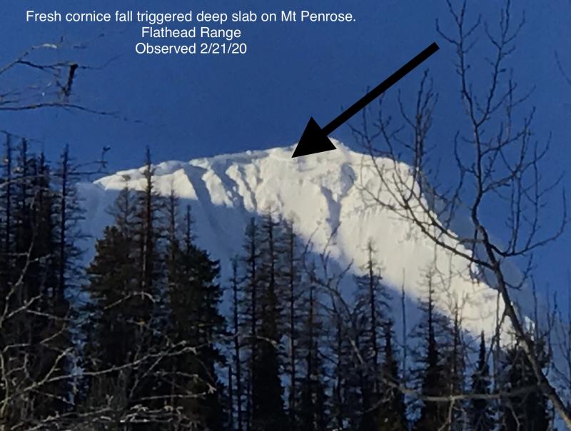
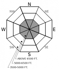
Deep persistent slabs remain a low likelihood, high consequence concern in alpine locations. They are becoming increasingly difficult to trigger, and all of the avalanche activity in the past few weeks has been associated with loading events or step-down avalanches. You might find the sour spot, however, on steep, unsupported and/ or convex slopes. Debris from cornice falls or small slides in the upper snowpack could trigger these deeply buried weak layers. Reduce your risk by avoiding steep, rocky, convex upper elevation slopes with variable snow cover.
Yesterday's storm finished with 12+" in the Swan Range, 4" to 7" in the Whitefish Range, and 6" to 10" in the Flathead Range and Glacier Park. Limited observations suggest widespread loose dry and thin storm slab avalanche activity involving the new snow. These instabilities will be less reactive today as the low-density snow settles and bonds to itself. However, the instabilities that won't be quick to adjust are buried a foot or so below this new snow. Since our mid-January weak layers were buried, Noisy SNOTEL in the Swan Range has a picked up 3" of Snow Water Equivalent. Flattop in Glacier Park is at 2.2" of SWE, and Stahl Peak in the Whitefish Range is at 1.5" of SWE. Multiply by 10 to get a rough estimate of slab size, in inches, of the persistent slab problem.
Our job is to forecast for the likelihood of avalanches, but I've also been around the game long enough to forecast for human-involved accidents. And over the next few days, the danger will slowly subside, but the ingredients for an accident are still primed. Here's why: The snow quality is the best of this season and it is a great time to be riding the backcountry right now. Our January surface hoar layer is buried about 2 feet deep - the perfect depth for human triggering. In some areas, this layer is incredibly weak, while other slopes, non-existent or not-so-bad. You may not get feedback while ascending through trees, or dropping a cornice, or digging a pit at the top of your run. That isn't where the danger has been most active. It is waiting for you halfway down the run, after you've let your guard down.
There have been 11 avalanche fatalities in the Western US and Canada since the start of the year. Many of these have involved experienced groups, such as a Level 2 avalanche class that caught 5 students and an instructor by surprise. We aren't dealing with run-of-the-mill avalanche conditions and weak layers right now. Take a step back and look at the big picture. We have received reports of human-triggered or natural avalanches on these layers EVERY day since they were buried last weekend. What might have been a small and relatively manageable instability last weekend is now a thicker slab that will behave more erratically. Yesterday, I was jumping around on a small test slope with no results, but my partner made one turn on the slope and it avalanched. The gators are getting hungry in the moat. Bring your full arsenal of armor if you're heading for the castle. Keep close visual and verbal contact with your partners. Choose slopes where if you get caught, you won't get battered by trees or buried in a gulley. Don't get complacent halfway down the slope: keep with tight protocols of traveling one at a time until you are in safe terrain.
EDUCATION: It's a great time to hone your avalanche knowledge or start learning the basics. Name That Tune, Name That Avalanche - Montana Tap House- 01/24/2019 7:00 PM and Ladies Avalanche Awareness Talk - Kalispell Brewing Company -01/30/2019 6:30 PM.
Sign up for one of our upcoming classes: Motorized Introduction to Avalanches 01/31/2019 to 02/02/2019, Companion Rescue Clinic 02/09/2019 and Introduction to Avalanches (non-motorized) 02/28/2019 to 03/02/2019.
A relatively benign day is on tap for the mountains. Winds will increase out of the west into the teens with temperatures rising into the low to mid 20's. We could see a few flurries under patchy cloud cover. Sneaky cold smoke powder watch for tomorrow morning: Northwest flow will produce showery weather that could hit up to 8" in localized areas.
This forecast applies only to backcountry areas outside established ski area boundaries. The forecast describes general avalanche conditions and local variations always occur. This forecast expires at midnight on the posted day unless otherwise noted. The information in this forecast is provided by the USDA Forest Service who is solely responsible for its content.


