| Wednesday | Wednesday Night | Thursday | |
|---|---|---|---|
| Cloud Cover: | Partly cloudy | Mostly cloudy | Overcast |
| Temperatures: | 28 to 33 deg. F. | 15 to 20 deg. F. | 21 to 26 deg. F. |
| Wind Direction: | South | Southeast | East |
| Wind Speed: | 5 to 15 mph | 5 to 15 mph | 10 to 20, gusting to 30 |
| Snowfall: | 0 in. | 0 in. | 2 to 3 in. |
| Snow Line: | 2500 | 2500 | 2000 |
Whitefish Range
Swan Range
How to read the forecast
Avalanche activity has dwindled since last week and the snowpack is generally stable. Be cautious of high elevation slopes with thin or variable snow coverage, especially below cornices.

1. Low
?
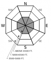
Above 6500 ft.
1. Low
?
5000-6500 ft.
1. Low
?
3500-5000 ft.
- 1. Low
- 2. Moderate
- 3. Considerable
- 4. High
- 5. Extreme
-
Type ?
-
Aspect/Elevation ?

-
Likelihood ?CertainVery LikelyLikelyPossible
 Unlikely
 -
Size ?HistoricVery LargeLargeSmall

We have observed slides breaking up to 5 feet deep from upper elevations of Flathead Range and Glacier Park as recently as last Thursday. We have seen fewer avalanches and signs of instability in the Swan and Whitefish Ranges in the past month. These instabilities are becoming increasingly stubborn and isolated under the past week of mild weather, but the consequences of an avalanche breaking on old layers will be severe. If you are traveling in high elevation, alpine terrain, be selective about your ascent and descent routes. Stick to concave terrain features where snow depths are more consistent and you cross fewer potential trigger points, like shallowly-buried rocks or margins of cross-loaded slabs.
Time heals everything, but some wounds are slow to heal. After a week of mild weather, the weak layers that formed during our dry weather this fall are slowly adjusting to the 3 to 5+ foot slabs above them. Some slopes, however, are slower to adjust. Triggering a thick and dangerous persistent slab has trended to unlikely in our forecast area because these stubborn problems are becoming increasingly isolated. As a backcountry traveler with only a shovel and snow saw at your disposal, it is very challenging to assess which slopes still hang in the balance. Thus, our travel advice is to remain cautious and choosy when venturing into the high alpine. This morning's forecast highlighted a report of a fresh natural D3 slab that broke on old weak layers near Castle Mountain Resort in Alberta, north of Glacier Park. It was from a steep, unsupported slope below a cliff feature. However, an update at 9:00 a.m. today relayed that the slide was a week old; sorry for the confusion. Regardless, this is the type of terrain we are most worried about, and this terrain is more widespread in Glacier Park and the Flathead Range. The Essex area has been the epicenter of persistent slab activity in our region. Reports of whumpfing collapses and propagating test results over the weekend highlight the problem. The bulk of natural persistent slab activity last week was reported from Lake McDonald and in the Middle Fork, with slides failing as recently as last Thursday. Persistent slabs have been breaking on steep, convex slopes sprinkled with rocks or variable snow depths. You are better off choosing well supported, deep, uniform slopes to fend off this low likelihood but high consequence problem.
EDUCATION: It's a great time to hone your avalanche knowledge or start learning the basics. Sign up for one of our upcoming classes: Ladies Introduction to Avalanches Class 01/17/2019 to 01/19/2019, Ladies Avalanche Awareness Talk - Kalispell Brewing Company -01/30/2019 6:30 PM, Motorized Introduction to Avalanches 01/31/2019 to 02/02/2019, Companion Rescue Clinic 02/09/2019 and Introduction to Avalanches (non-motorized) 02/28/2019 to 03/02/2019.
Another mild day in the mountains is in store for today while cloud cover is slow to break down. A pattern change arrives tomorrow - snowfall will spread across the mountains and increase in intensity by Friday.
This forecast applies only to backcountry areas outside established ski area boundaries. The forecast describes general avalanche conditions and local variations always occur. This forecast expires at midnight on the posted day unless otherwise noted. The information in this forecast is provided by the USDA Forest Service who is solely responsible for its content.


