| Tuesday | Tuesday Night | Wednesday | |
|---|---|---|---|
| Cloud Cover: | Partly cloudy | Mostly cloudy | Mostly cloudy |
| Temperatures: | 25 to 30 deg. F. | 10 to 15 deg. F. | 25 to 30 deg. F. |
| Wind Direction: | E | S | S |
| Wind Speed: | 5 to 10 | 5 to 10 | 5 to 15 |
| Snowfall: | 0 in. | 0 in. | 0 in. |
| Snow Line: | 2500 | 2000 | 1500 |
Whitefish Range
Swan Range
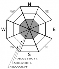
How to read the forecast
Mild weather has allowed the snowpack to slowly strengthen. It's also provided a window of great travel and riding conditions up high. That window is closing faster than the danger is diminishing, so continue to pick your routes up to alpine terrain and down exposed slopes carefully. Minimize the consequences of triggered slides by exposing one rider at a time and picking lines that aren't above terrain traps like cliffs, gullies and trees.

1. Low
?
Above 6500 ft.
1. Low
?
5000-6500 ft.
1. Low
?
3500-5000 ft.
- 1. Low
- 2. Moderate
- 3. Considerable
- 4. High
- 5. Extreme
-
Type ?
-
Aspect/Elevation ?

-
Likelihood ?CertainVery LikelyLikelyPossible
 Unlikely
 -
Size ?HistoricVery LargeLargeSmall

Alpine terrain is home to the best riding conditions right now. But some steep, upper-elevation slopes still harbor weak snow. On isolated slopes, there may be slabs that are still sensitive to person’s weight. So if you venture into this terrain, be very picky about your ascent and descent routes. Stick to concave terrain features where snow depths are more consistent and you cross fewer potential trigger points, like shallowly-buried rocks.
Winds shifted easterly or northerly overnight and increased. They're forecast to continue at light to moderate speeds today. That means that downwind of saddles, passes, and other features that funnel winds, you may see some drifting snow. It’s not likely to be enough to form more than a few pockets of shallow wind slabs, if that. Look for these as you explore higher terrain, and reconsider steep, consequential slopes below thin slabs, especially those that crack around your boards or sled.
In the Whitefish and Swan Ranges, conditions are generally stable. We haven’t had reports of triggered Persistent Slab avalanches in either zone in a week. The last report of a triggered Persistent Slab avalanche involved a large trigger (cornice) in very steep terrain in the southern part of the Swan Range. That was over a week ago, and our only other reported sign of instability related to persistent slabs was shooting cracks in the northern part of the Swan Range. Snow profiles at mid-elevation sites in the Whitefish Range show a well-consolidated slab over an unreactive layer of basal facets. There are undoubtedly slopes where the slab is thinner, midpack weak layers exist, or the basal facets are still weak and sensitive to the weight of a person. These booby traps are likely confined to the highest, most exposed slopes, ones where early season snow lingered and winds have scoured and drifted snow.
However, different conditions exist in the eastern reaches of the forecast region, in the Flathead Range and Glacier Park. Storms last week produced a natural cycle of Persistent Slab avalanches around McDonald Creek and the northern and central drainages of the Flathead Range. People have also reported whumpfing collapses, propagating test results, and a remotely-triggered avalanche in the John F. Stevens Canyon area. It's clear that that the Persistent Slab avalanche problem is lingering in alpine terrain, and the danger is higher in this zone. The mild weather since Thursday is giving the snowpack time to adjust, and slabs are becoming more stubborn with each passing day. However, the size the natural avalanches last week shows that triggered slides would be large, hard to escape, and involve deep debris.
EDUCATION: It's a great time to hone your avalanche knowledge or start learning the basics. Sign up for one of our upcoming classes: Ladies Introduction to Avalanches Class 01/17/2019 to 01/19/2019, Ladies Avalanche Awareness Talk - Kalispell Brewing Company -01/30/2019 6:30 PM, Motorized Introduction to Avalanches 01/31/2019 to 02/02/2019, Companion Rescue Clinic 02/09/2019 and Introduction to Avalanches (non-motorized) 02/28/2019 to 03/02/2019.
Cold air from the east and a little moisture from the southwest will nibble at the high pressure that's driven conditions since late last week. Snow flurries possible in the valleys, with cooling temperatures and light to moderate winds at high elevations.
This forecast applies only to backcountry areas outside established ski area boundaries. The forecast describes general avalanche conditions and local variations always occur. This forecast expires at midnight on the posted day unless otherwise noted. The information in this forecast is provided by the USDA Forest Service who is solely responsible for its content.


