| Saturday | Saturday Night | Sunday | |
|---|---|---|---|
| Cloud Cover: | 45% | 30% | 45% |
| Temperatures: | 30 to 35 deg. F. | 18 to 24 deg. F. | 29 to 34 deg. F. |
| Wind Direction: | SE | E | E |
| Wind Speed: | 5 to 10 | 5 to 10 | 5 to 10 |
| Snowfall: | 0 in. | 0 in. | 0 in. |
| Snow Line: | 3000 | 3000 | 3000 |
Whitefish Range
Swan Range
Flathead Range and Glacier National Park
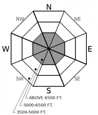
How to read the forecast
A strengthening inversion will offer sunshine and mild temperatures above the valley cloud deck. The snow surface is generally stable but we are still concerned about deeply buried weak layers. Choosing terrain with planar slopes and deep uniform snow cover is the best way to manage this problem. Areas with a rocky variable snowpack should be viewed with suspicion.

2. Moderate
?
Above 6500 ft.
1. Low
?
5000-6500 ft.
1. Low
?
3500-5000 ft.
- 1. Low
- 2. Moderate
- 3. Considerable
- 4. High
- 5. Extreme
-
Type ?
-
Aspect/Elevation ?

-
Likelihood ?CertainVery LikelyLikelyPossible
 Unlikely
 -
Size ?HistoricVery LargeLargeSmall

Persistent slab avalanches occurred during Monday's storm with thick slabs failing on buried weak layers. These remain a concern for both natural triggering and human triggering by a rider who finds a thin spot in the slab with resulting slides large and destructive. Terrain management remains the easiest way to manage this problem with planar slopes harboring a thick uniform snowpack preferable to rocky convex terrain with variable snow depth. Collapses or whumpfs are obvious signs to avoid steep terrain.
Observations yesterday revealed a strong snow surface in the Flathead Range and interior Glacier Park. Recent warm storms left a rain crust from the valley floor to mid and upper elevations with a dense storm slab above this. We are in the midst of a multi-day inversion with sunshine and mild temperatures above the valley cloud deck. Despite the abundant solar input the snow surface remains frozen with minimal wet snow instabilities. We removed Loose Wet from today's problem list but small isolated wet snow instabilities may be found on steep sunny slopes. These slides will be generally harmless but If you find yourself sinking into the snow use caution in long-running gullies and while traveling above terrain traps.
We continue to be concerned with deeply buried weak layers that have resulted in large persistent slab avalanches during the past 2 storm cycles. Weak layers are gaining strength and becoming increasingly difficult to trigger. Unfortunately, this is a low-probability high consequence problem with resulting avalanches large, dangerous, and destructive. Terrain management remains the best way to avoid this problem with areas containing a thin snowpack, convexities, or steep rocky slopes the likely trigger points. Planar terrain with a deep uniform snow cover is a better choice until we can remove Persistent slabs from our problem list.
This forecast applies only to backcountry areas outside established ski area boundaries. The forecast describes general avalanche conditions and local variations always occur. This forecast expires at midnight on the posted day unless otherwise noted. The information in this forecast is provided by the USDA Forest Service who is solely responsible for its content.


