| Friday | Friday Night | Saturday | |
|---|---|---|---|
| Cloud Cover: | Partly Cloudy | Partly Cloudy | Partly Cloudy |
| Temperatures: | 30 to 35 deg. F. | 5 to 15 deg. F. | 33 to 38 deg. F. |
| Wind Direction: | Southwest | Southwest | South |
| Wind Speed: | 5 to 10 | 5 to 10 | 5 to 10, gusting to 15 |
| Snowfall: | 0 in. | 0 in. | 0 in. |
| Snow Line: | 4000 ft | 3000 ft | 4500 ft |
Flathead Range and Glacier National Park
How to read the forecast
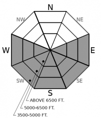
Happy June-uary! As the sun comes out in the mountains today, look for wet surface instabilities like rollerballs and small sluffs. The snow in steep, rocky terrain will warm the most. Watch out for cornices falling from overhead. We are still concerned about weak layers buried under thick slabs. Use caution on steep slopes, convexities, and in rocky terrain.

2. Moderate
?
Above 6500 ft.
2. Moderate
?
5000-6500 ft.
1. Low
?
3500-5000 ft.
- 1. Low
- 2. Moderate
- 3. Considerable
- 4. High
- 5. Extreme
-
Type ?
-
Aspect/Elevation ?

-
Likelihood ?CertainVery LikelyLikelyPossible
 Unlikely
 -
Size ?HistoricVery LargeLargeSmall

Monday's storm produced numerous persistent slab avalanches that broke several feet deep in the Flathead Range at middle and upper elevations. Don’t let your guard down in the sunshine. Thick slabs over buried weak layers in the middle and lower snowpack continue to be a concern. Steep, rocky, convex terrain, should give you second thoughts. Shooting cracks and audible whumpfs are shout-outs from the snowpack telling you to seek out lower angled, planar slopes with deep, uniform snow cover. Cornices can fall in warm weather and trigger large slides on the slopes below.
-
Type ?
-
Aspect/Elevation ?

-
Likelihood ?CertainVery LikelyLikelyPossible
 Unlikely
 -
Size ?HistoricVery LargeLargeSmall

Sunshine and warm temperatures means wet snow instabilities. Steep, rocky, southerly slopes will harbor the biggest risk. Even small sluffs can be dangerous above terrain traps like cliffs, gullies, or trees. Warm temperatures can also cause cornices to pop off of ridgelines triggering slides below. You can manage the problem easily enough: move to shadier slopes before the snow becomes wet and saturated.
The storm snow from Monday continues to gain strength. Observers in the Whitefish Range yesterday saw only small sluffing, and localized cracking in very steep terrain. As a quiet period of high pressure settles into the area, daily warming and frequent sunshine will drive surface melting. Rollerballs and small sluffs in wet snow will continue to be the concern in steep terrain that warms the most. Rocky gullies will hold the most heat. Sinking into wet surface snow means it’s time to move to shady slopes.
Large persistent slab avalanches failed at middle and upper elevations in the Flathead Range during Monday’s storm. Up to 1.7” of snow water equivalent in some areas has loaded the snowpack since then. The increased weight will keep persistent slabs possible where dense slabs overlay weak sugary snow. Cornice falls, or a smaller slide could trigger deeper persistent layers buried at the bottom or middle of the snowpack. A snowmobiler in the Swan Range yesterday reported long cracks shooting across a slope, which is a classic sign that these layers can fail under your weight. Shallower snow cover, convexities, and steep rocky slopes are the likely trigger points. Cracking or whumpfing should direct you away from avalanche terrain and onto low angled slopes with deep, uniform snow cover.
EDUCATION: We are offering the following upcoming classes: Motorized Level 1- Avalanche Fundamentals course on January 11-13, and a Ladies Introduction to Avalanches January 17 and 19
The double-edged sword of high pressure will dominate our weather the next few days. Up high, expect partly cloudy skies, light winds, and mild temperatures. Inversions will leave the valleys in fog.
This forecast applies only to backcountry areas outside established ski area boundaries. The forecast describes general avalanche conditions and local variations always occur. This forecast expires at midnight on the posted day unless otherwise noted. The information in this forecast is provided by the USDA Forest Service who is solely responsible for its content.


