| Thursday | Thursday Night | Friday | |
|---|---|---|---|
| Cloud Cover: | Mostly Cloudy | Mostly Cloudy | Partly Cloudy |
| Temperatures: | 29 to 39 deg. F. | 17 to 22 deg. F. | 27 to 37 deg. F. |
| Wind Direction: | Southwest | Southwest | South |
| Wind Speed: | 5 to 15 mph, gusting to 30 | 5 to 15 mph, gusting to 20 | 3 to 13 mph, gusting to 20 |
| Snowfall: | 1-5 in. | 0 to 1 in. | 0 in. |
| Snow Line: | 5000 ft | 5000 ft | 4500 ft |
Whitefish Range
Swan Range
How to read the forecast
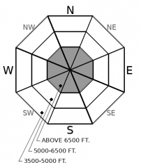
Aww crud! After a poor refreeze overnight, the mountains will get another few inches of dense, heavy snow today. It will be possible to trigger small moist sluffs in steep terrain as the day warms. Look for rollerballs and small sluffs as the primary signs of surface instability. Be wary of cornices teetering overhead. Deep weak layers are still a concern, especially in complex, rocky, alpine terrain in the Northern Whitefish Range, the Flathead Range, and Glacier Park.

2. Moderate
?
Above 6500 ft.
1. Low
?
5000-6500 ft.
1. Low
?
3500-5000 ft.
- 1. Low
- 2. Moderate
- 3. Considerable
- 4. High
- 5. Extreme
-
Type ?
-
Aspect/Elevation ?

-
Likelihood ?CertainVery LikelyLikelyPossible
 Unlikely
 -
Size ?HistoricVery LargeLargeSmall

Warm dense snowfall continues to add weight to old, thick slabs over buried weak layers in the middle and lower snowpack. Cornice falls can trigger buried weak layers causing a large and destructive avalanche. Even a single rider on the wrong slope could trigger a dangerous slide. Steep, rocky, convex terrain, and alpine slopes under cornices should give you the most concern, especially in areas with complex layers of weak snow under denser slabs. Collapses or whumpfs are clear signs to avoid avalanche terrain and stick to planar, sheltered slopes with deep, uniform snow cover.
-
Type ?
-
Aspect/Elevation ?

-
Likelihood ?CertainVery LikelyLikelyPossible
 Unlikely
 -
Size ?HistoricVery LargeLargeSmall

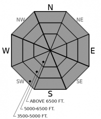
Warm wet conditions yesterday were followed by a poor refreeze overnight. A few more inches of dense, moist snow may fall today and make small wet sluffs possible. Steep rocky slopes, especially those with a more southerly aspect, will harbor the biggest risk. Even small sluffs can be dangerous above terrain traps like cliffs, gullies, or trees. Warm temperatures can also cause cornices to pop off of ridgelines triggering slides below. Rollerballs and small sluffs are signs that stability is deteriorating.
We have seen few remaining instabilities in the storm snow from Monday. Our limited observations for the past few days show only localized cracking in small wind drifted snow. Warm weather and a few inches of dense snow have been driving surface instabilities. Rollerballs and small sluffs in moist snow (example 1, example 2) will continue to be the concern in steep terrain that warms them most.
Keep in mind the possibility of shallow storm slabs and small fresh wind drifts in alpine terrain where the snow is dry and wintry.
The recent warming and continued loading has added a lot of weight to already thick hard slabs of snow that overly buried weak layers. We have heard the most about deeper facet layers in the Flathead Range. But a layer of surface hoar developed just after Christmas at upper elevations in the Swan and northern Whitefish Ranges. Observers at Red Meadow on January 3rd reported this layer already buried by 8-14” of newer snow. That area has received an additional 1.5” of snow water equivalent since that time which makes us nervous, and so we’ve changed the likelihood of persistent slabs from unlikly to possible. A cornice popping off its perch, or a smaller shallower slide could trigger weak layers buried at the bottom or middle of the snowpack. These problems are more reactive during loading events. A single rider who is unlucky enough be on the wrong slope could trigger these layers as well. Shallower snow cover, convexities, and steep rocky slopes are the likeliest trigger points on slopes harboring buried facets or surface hoar. Cracking or whumpfing should direct you away from avalanche terrain and onto low angled slopes with deep, uniform snow cover.
EDUCATION: We are offering the following upcoming classes: An Avalanche Awareness talk on Thursday, January 10 at The Stonefly Lounge at 7:00 p.m., a Motorized Level 1- Avalanche Fundamentals course on January 11-13, and a Ladies Introduction to Avalanches January 17 and 19
Light showers of snow and mixed precipitation today will diminishing by tonight before strong high pressure builds quickly into the region tomorrow.
This forecast applies only to backcountry areas outside established ski area boundaries. The forecast describes general avalanche conditions and local variations always occur. This forecast expires at midnight on the posted day unless otherwise noted. The information in this forecast is provided by the USDA Forest Service who is solely responsible for its content.


